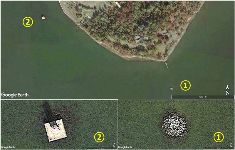
A circular pile of rocks southeast of North Point (Site 1 on Image 1) at the mouth of the Patapsco River had been a mystery. Charted as an obstruction, I supposed it could be a ballast pile but the rocks are much larger than what could be manhandled. The National Oceanographic and Atmospheric Administration’s online historical map and chart collection is a superb resource that sometimes helps shed light on lost Bay history. Working back through the historic charts, the 1923 approach chart showed an old tower where the obstruction is located. An 1857 approach chart showed and named two lighthouses. That reveal enabled unraveling the rest of the story about what is now fishing structure.
“Mrs. E. Riley, keeper, assistant, deaf and dumb son, who performed the duty of keeper to both lights: has kept for 23 years.” So goes an 1851 lighthouse report about North Point Upper and Lower Lighthouses marking the North Point Shoal and the north side entrance to the Patapsco River and their keeper, Elizabeth Riley. She apparently succeeded her husband as keeper in 1834, and wasn’t the only woman who served as keeper under the U.S. Lighthouse Service, later incorporated into the U.S. Coast Guard. As a buoy tender sailor, I was intrigued and wanted to learn more — and also assess the fishing potential.
Two range lights for North Point were appropriated by Congress in 1819, 1822, and 1823. There are no pictures. But the lights were contemporary with the Bodkin Point Light, which was a masonry structure. We find from an 1838 inspection report at lighthousefriends.com that “These lights are built on piers about 150 yards from the shore, and are brought in a range in steering for the harbor of Baltimore. They are very important lights, but, in consequence of the humidity of the atmosphere in the lanterns, they cannot be seen at a proper distance.” The report went on: “Tower rubble-stone, badly built; pointing good; stucco bad.” So, there we have it, masonry structures consisting of rubble stone and mortar.
A concise history of the North Point Ranges lights posted by cheslights.org is more complete: “The two whitewashed masonry towers were constructed and completed in 1822. The eastern tower (lower light) stood in three feet of water and was connected to the shore by a 200-foot walkway. The western tower (upper light) stood in five feet of water approximately 700 yards from the eastern tower, 100 yards from the shoreline.” Based on these brief descriptions and existing conditions, remnants are still there.
According to the 1874 Lighthouse Service inspection report “These lights were discontinued (1873) when the Craighill Channel range had been established and mariners had become accustomed to them, as their use was no longer necessary. The lens and supplies were removed and sent to the general depot. The old towers on North Point will be retained as day-marks.”
Historical records from the Coast Guard Historian’s Office document show that Congress appropriated funds for construction of range lights for the new Craighill Cut-Off Channel in 1885 and construction on them and a keeper’s house ashore began in that year. An assessment for including the front range, marked Site 2 on Image 1, on the National Historic Register reports: “It was first proposed to use the rear tower of the old North Point Range as the front beacon for the new Cut-off Channel Range Light Station, but careful examination showed it was unsuitable for that purpose. Plans were, therefore, draw up for a new brick tower, octagonal in shape, to be built on the old stone foundation of the North Point Lighthouse.”
The Historian’s Office reports that the former tower was dismantled. A small bridge connected the light to the keeper’s house ashore. The bridge was destroyed by a storm in 1893. “Rather than rebuild the bridge, it was decided that the keeper would move into the less than 12-foot-square lighthouse and use a skiff to get to shore.” Based on these historical records, I believe that the rocks on the north and east side of the front range shown by Google Earth (lower left insert of Image 1) and Coast Guard historic photos are where the rubble rocks from the 1822 lighthouse were disposed of onsite.
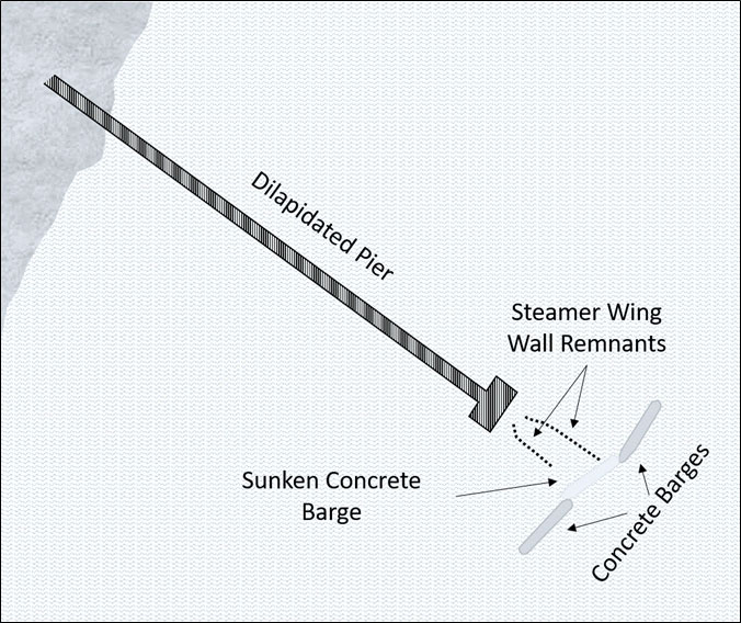
Water depths around the lighthouse rock ruins are shallow. The north and east sides of the range light are foul because of the disposed rocks. There potentially may also still be broken off, deteriorated piles from the old small bridge that was carried away. These features, located as they are at the harbor entrance, have better water quality than inside the harbor. They also provided foraging opportunities for striped bass and white perch. Other nearby features to cast to on the north side include the riprap around the end of the fishing pier causeway at Bay Shore Park and the three sunken scows off the end of the abandoned Ferry Grove Pier steamer landing, shown in Image 2, at North Point State Park. The pier is highly deteriorated and parts are beginning to collapse. Depths are very shallow around the pier, but the scows can be approached from the Bay side.
- By Wayne Young. As well as being a regular contributor to FishTalk, Wayne Young is the author of multiple books detailing wrecks and fishing reefs in the Chesapeake Bay, Delaware Bay, and beyond. All are available at Amazon.com, and you can find his Facebook page at Chesapeake Bay Fishing Reefs.