If you want to catch the most and biggest flounder you’ve ever seen during a single day of fishing in the spring, one of the best places to offer this kind of opportunity lies on the Eastern Shore of Virginia in the waters of Wachapreague. Some have called this town the “Flounder Capital of the World,” and we wouldn’t begrudge Wachapreague the title. In fact, we find it quite fitting that this dazzling metropolis, with its 240 or so year-round residents and massive two-story sky-scrapers, gets credit when credit is due. And when it comes to springtime fluke fishing, these waters are utterly fantastic.
Actually, they’re fantastic year-round for a number of species. The inlet commonly sees a drum run shortly after the flounder peak, the channels and cuts get jam-packed with everything from croaker to weakfish during the summer months, and excellent offshore fishing awaits anyone departing from this port. Yet it’s that initial flounder run, starting as early as late March some years and often continuing well into the spring, which draws crowds of anglers from all around the Mid-Atlantic region. With that in mind, let’s take a close-up look at what makes this hotspot so special.
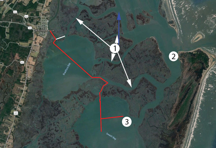
Chart #1
Looking at chart number one, note the red line cutting through Bradford and then Swash Bay. We added this onto the satellite image to give those who may not be familiar with these waters some concept of where the channel runs, to get to Hotspot number three. (NOAA chart 12210 shows the channels and markings but can also be a bit misleading as mudflats which are usually under water appear as dry land, so we chose to use Google Earth in this case). More on this spot later – we’ll look at it in detail – but for the moment the important concept to grasp is that this channel runs through a combination of mud flats, open bays, and cuts through the marsh. This is a unique waterway, with an amazing mix of 40-foot depths and oops-I-ran-aground moments. In fact, we’re going to go out on a limb here and say that if you’ve ever been to Wachapreague, you’ve also run aground in Wachapreague. Most of us (excluding that handful of locals, of course) are likely to rub bottom multiple times on every Wachapreague trip. Don’t worry about it, folks; it’s all part of the adventure.
Assuming you manage to tilt the engine up, push the boat out of the mud, and make it to any one of the marsh cuts identified by the arrows indicating Hotspot #1 on this image, congratulations. You’ve made it to fishable waters. While these creeks and cuts are not normally considered prime for early spring flounder, they do commonly hold fish, mostly along the edges of the drop-offs which can be targeted during falling and low tides. These drops are extremely sheer in many places, and you can easily be in four feet one second and 40 feet the next. When fishing these edges for flounder make sure you stay on the drops and don’t waste a lot of time drifting through the middle of the channel, where you’ll catch far fewer fish. When the bite is red-hot and the other hot-spots are cramped with a flotilla of boats, these creeks and cuts sometimes offer still-decent fishing, with a lot less competition. Otherwise, they’re better filed away for summertime trips when you might be going after that myriad of “other” species. Because if spring flatties are in your sights and the water isn’t simply riddled with fish, Hotspots #2 and #3 are going to be much more important.
One important exception: The blue arrow running north, which points to the beginning of the Hummocks. There’s a channel here which runs north/south, close to the marsh islands (on the west side) with mud flats off to the north and east. Some years this is an excellent area, particularly for fluke trollers who can parallel the edge of the channel (which is fairly straight in a north-south orientation) during a falling tide, when there may be good numbers of fish returning to the deeper water of the channel.
Hotspot #2, inside the mouth of the inlet, identifies the area of water you’ll commonly hear referred to as “off the Coast Guard Station.” That’s how most people describe this area where flounder pour into the bay from the ocean. At times this is a prime spot to intercept the fish. But it’s usually an on-again, off-again kind of spot. Flounder don’t seem to congregate here and stick around or any long period of time so much as move through as they enter the bay from the ocean. Intercept a slug of fish moving through, and the bite can be epic. Get here on the wrong day, and it can be deserted. So many anglers will check here but move on if there doesn’t seem to be a strong bite, as opposed to investing a lot of time in the area.
Shoals here come well out from land, and the sharpest drops with the deepest water are usually found a bit farther west than one might expect (close to the outer edge of the white circle marking the hotspot). There are also good depths and drops on the northern side, though it can be a bit rough here at times. But we have to keep using words like “usually” and “at times,” because many of the shoals this close to the inlet shift and change on a regular basis. Remember what we said earlier, about running aground? If you come here once a year, you may discover completely different depths in exactly the same GPS location from one trip to the next.
Again, a key to success here is staying on the drop-offs. Flounder hunt where the depths change in this environment and rarely feed in the static depth of the channels. The biggest mistake most anglers make is to spend a few minutes drifting down a ledge or drop, and then continue drifting for 10 or 15 minutes through the deep waters of the channel. Once the depth levels out, your chances of hooking a fish drop significantly and though it takes a lot more effort, serious anglers will focus on constantly maneuvering and/or repositioning the boat to stay along the drops. (Hint: this is why trolling can be so effective here sometimes, as it allows you to constantly stick with a productive depth range).
Spring Shallow-Water Flounder Tactics
In deep water the results are debatable, but in the shallows casting bucktails and jigs (often sweetened, as mentioned earlier) usually out-fishes baits. This is something of a finesse fishery; you’ll need to maintain intermittent contact with the bottom in a mere one to three feet of water without snagging. Choosing a relatively light head (a quarter to an eighth of an ounce) tied with lots of thick hair or a buoyant plastic helps both slow the sink rate and maintain a large profile. Let the lure hit bottom after it’s cast, then raise the tip high while jerking it off bottom. Slowly drop the rod tip as you retrieve until you feel the lure touch bottom. When you do, give it a vigorous jerk to bring the lure back up high. Ideally, the rod will be parallel with the water when it’s time to jerk the lure back up again. This will allow you plenty of swing for hook-sets, which should also be vigorous, and should take place the instant you feel a hit.
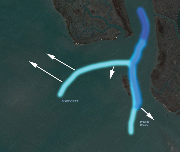
Chart #2
Chart #2 is all about Hotspot #3, which is without question the most well-known reliable spring flounder fishing spot in Wachapreague, and possibly is the most famous along the entire Eastern Shore: Green and Drawing Channels. Sometimes you’ll also hear this general area referred to as “Swash Bay,” which is the larger body of water these channels lead into. This is a prime area to fish for shallow water flatties on a flood tide, casting jigs or bucktails sweetened with a minnow, squid strip, or GULP. The north side of Green is particularly good for this tactic, especially when you find an oyster bar with just a couple of feet of water around it and fish the edges.
The best way to approach this area is to act exactly like the fish do: as the tide comes up move shallower and shallower, first intercepting fish where the channels meet the shallows and the flounder transition out of deep water (light blue areas). Then on the flood look for spots where the sun warms the water over dark mud shallows (white arrows), and there are good hunting opportunities nearby. As the tide falls again shift back towards the transition points. And when it’s low, stick to the channels and deeper-water areas (darker blue).
We should note that although Wachapreague gets most of the headlines and most of the glory when it comes to springtime flounder fishing, there are also some excellent opportunities to be found in nearby waters like Chincoteague, Quimby, and Oyster. An added attraction for these other ports is the fact that the crowds are often much thinner; the waterways of Wachapreague can become quite clogged with boats on a sunny, calm spring weekend. And when one of the flounder tournaments is going on, if you’re not going to enter the competition our advice is to look elsewhere – it can become quite a mad-house, as anglers from all over the Mid-Atlantic region descend on the Flounder Capitol of the World.
By Holly Innes
Sign up here to get the weekly FishTalk Chesapeake Bay and Mid-Atlantic fishing reports in your email inbox, every Friday by noon.