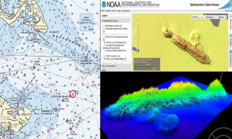
When trying to find specific Chesapeake Bay fishing reef structure, it’s best to know where to look or else count on spending a lot of time playing hunt and find. I knew the gravesite of the ironclad harbor-defense ram USS Katahdin was somewhere off the Rappahannock Spit, after reading Gary Gentile’s extensive writeup in his dive series book about Virginia’s Chesapeake Bay shipwrecks. So, that’s where I started armchair scouting for “Old Half-Seas Under” as she was known. Gary said it was marked as an obstruction, and various descriptive reports put the remains of this experimental naval ship somewhere along the spit in about 25 feet of water. It’s not there, although not far away. A side-scan-like sonar image of the wreck was right there on the computer screen, if I had been looking in the right place.
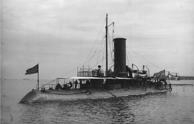
Motivated by a perceived need for a fleet of harbor defense rams advocated by a senior admiral, the U.S. Navy received authorization and appropriations for and contracted construction of a prototype ship. The ram would rely on ramming for offensive power to protect ports and coastal shipping lanes from enemy ships. The concept: unarmed rams would be more effective in port and coastal waters than offensive firepower. The return to the ancient naval warfare doctrine of using rams was unsuccessful. Nevertheless, the vessel’s innovative design and subsequent use in tests informed development of warship armor and submarines. The streamlined turtleback hull had continuous curves, a design feature that was incorporated into early submarines. There was also a double-bottom that could be partially flooded. The objective was to lower the vessel’s silhouette, thereby reducing target size.
The hull was constructed from mild steel. Overall length was 251 feet and width was 43.5 feet. Nickle steel inclined armor three to six inches thick was attached to the hull. The smokestack and ventilators each had armor six inches thick. The conning tower armor was 18 inches thick. Although there was no armament, the ship was equipped with four six-pounder rapid-fire guns. They were intended as a defensive capability against torpedo boat attacks. For offensive defense, a removeable wrought-steel ram-head was fitted into a cast-steel stem. Two engines with reversing gears were installed in line with each other. Both were in a watertight compartment with watertight doors. One engine turned the port and the other turned the starboard screw. Three-bladed propellers of manganese-bronze were installed. Design speed was 17 knots. During trials, the vessel topped out at just over 16 knots.
Katahdin was launched in 1893, and saw brief service in coastal defense during the Spanish American War. She was decommissioned, and subsequently designated as Ballistic Experimental Target A. Large plates of armor were attached in an upright position athwartship as targets for ballistic tests to assess the resisting power of armor. Test-firing from large caliber naval guns up to 12 inches were conducted at the mouth of the Rappahannock River. After each test, the ram was towed back to port in Tidewater, assessed for ballistic penetration, and damage repaired in preparation for the next tests.
After gunfire tests in September 1909, the ship began sinking at anchor somewhere off Rappahannock Spit. Salvage proved impractical. In fine naval tradition, the wreck was used as a gunfire target until she slipped below the waves into oblivion and the wreck was subsequently charted as an obstruction. Nevertheless, over time, the Katahdin disappeared from public awareness, except perhaps for fishermen with local knowledge of an elongated mound. Also, although unexploded ordnance is not shown as a warning on nautical charts for this area, the potential for encountering it is nevertheless present at yet another Bay area that was used for ballistic purposes.
Gary Gentile included geographic coordinates for a host of wrecks in his detailed dive guide series books for Maryland and Virginia Chesapeake Bay waters, but the Katahdin isn’t among them, notwithstanding his comment that the wreck was recorded as an obstruction. A contractor for a National Ocean Survey field survey located the wreck in 2007 and confirmed the charted position (76’25.0 x 37’57.2), although it was described as an obstruction with no mention of wreckage. Perhaps after more than 100 years, she is heavily encrusted with marine organisms. The results of the survey were documented in a National Ocean Service Descriptive Report and incorporated into a 2008 chart update. The Katahdin wreck was also included in the side-scan-like images available using the National and Oceanic Atmospheric Administration’s (NOAA) Bathymetric Data Viewer (BDV).
The contractor’s narrative describes a wreck that is about 47 feet longer than the ram’s length; it appears that a section of the wreck may have separated from, but remained in line with, the rest of the hull. This could easily account for the variance in length. While the information available does not absolutely confirm that the Katahdin is where shown in this writeup, there aren’t any other contenders. The BDV image shows a profile that strongly resembles the Katahdin’s streamlined hull, and the width is about right. The obstruction must be the Katahdin.
That’s my story, and I’m sticking to it unless proven otherwise! Regardless, the resulting reef is a dandy — well worth trolling around, dropping a jig, live lining, or chumming and fishing with cut bait. Plus, the wreck is not only located where some protection is offered, but also near a host of other fishing hotspots, including VMRC’s Windmill Point Reef. With all her thick armor, this wreck is likely to be around for another 100 years. Thanks to the Navy for providing us with another great fishing reef.
See our Chesapeake Bay Fishing Reefs Guide to get the lowdown on other mad-made wreck and reef hotspots in the Bay, plus a few in the ocean off the DelMarVa coast.
Sign up here to get the weekly FishTalk Chesapeake Bay and Mid-Atlantic fishing reports in your email inbox, every Friday by noon.