The Virginia Marine Resources Commission’s (VMRC) artificial reef system provides substantial fishing structure throughout the southern half of the Chesapeake Bay. These man-made reefs often provide some of the more prominent three-dimensional relief around, notwithstanding that a number have natural structure nearby. With 18 Bay reefs covering both sides of the Bay and another five in the ocean, there’s good reef structure within reasonable running distances from almost anywhere along the Virginia shorelines. One of those of interest to anglers who fish in northern Virginia waters is Anglers Reef.
Getting to the Chesapeake Reefs
The VMRC has two primary resources available via the Internet that document reef deployments and layouts. Latitude and longitude can be extracted for individual reefs from grid drawings for each reef site. They were prepared using deployment data and Loran C readings, so you can’t expect perfection. There is also a geographic information system (GIS) for reef sites with reef icons overlaid on a base map, either a Google Earth satellite image or basic surface map (a nautical chart base map is currently not available, although may be a future upgrade). Zooming in on icons shows reef layouts as graphic shapes (except, at the time of this writing, for East Ocean View, Newport News, and York Spit Reefs). Clicking on a color-coded reef-shape icon produces a pop-up box with deployment information for most of the reefs. Some of the early reef Loran-C coordinates were verified using the Global Positioning System for the actual geographic coordinates of reef shape overlays, but not all of them.
Reacting to a decline in public funding for Virginia’s artificial reef program, the Virginia Saltwater Sportfishing Association (VSSA) took on providing financial support for reef development as a mission in 2017. The non-profit group produced the Virginia Artificial Reef Guide in print and electronic formats for the VMRC artificial reefs covered by NOAA’s Bathymetric Data Viewer (BVD) images. It includes geographic coordinates for individual artificial reefs and natural reef structure within and adjacent to fish haven boundaries with interpreted side-scan sonar images. Although not covering all the reefs, it supplements the information available and is helpful for setting waypoints prior to running to specific reefs. Sale proceeds support VSSA’s reef development and other non-profit activities. (For more information, go to joinvssa.org and click on the “Reef Program” button).
Anglers Reef
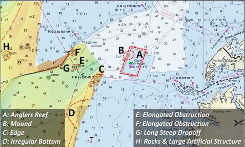
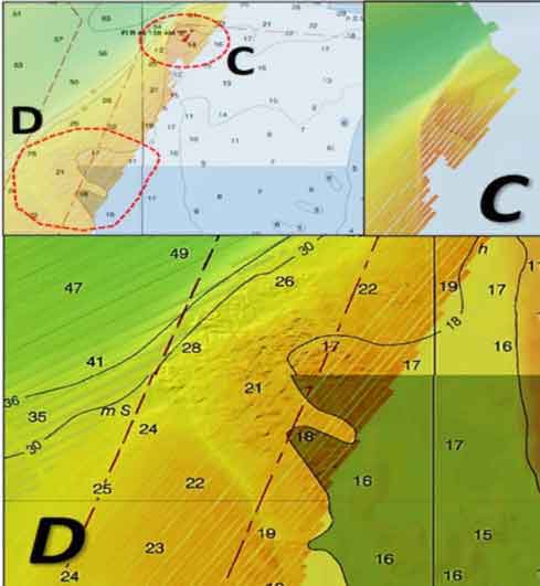
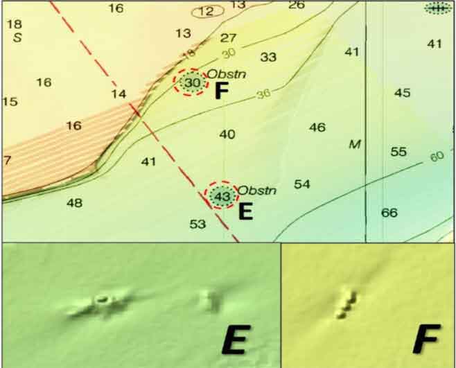
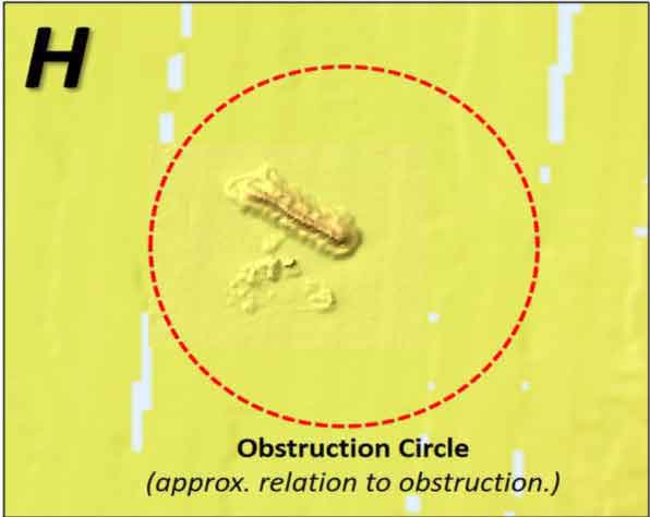
According to an early reef history by Jon Lucy for the Virginia Institute of Marine Science, the Anglers reef was established in 1969 by the Eastern Shore Anglers Club. Originally known as the Onancock Creek Reef, the site is about two and a half miles south of Watts Island rocks, and about the same distance from the entrance to Onancock Creek on Virginia’s Eastern Shore. That’s about 14 miles south of Janes Island, within range for Maryland anglers fishing from Crisfield. NOAA BDV coverage is close by Anglers, revealing some interesting natural structure and obstructions to the northwest, west, and southwest. The reef also lies at the southern end of a deep-water channel which runs towards the northeast to the mouth of Pocomoke Sound. Depths go down to almost 90 feet. The channel is characterized by steep edges and includes one very prominent underwater ledge that pokes well out into the channel. Many other natural features in the area including Pocomoke Sound are well covered in the book “Rudow’s Guide to Fishing the Chesapeake.”
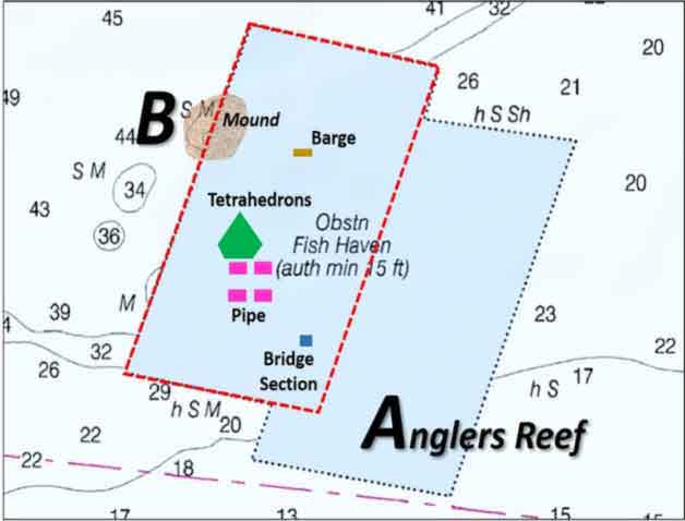
The boundary for Anglers Reef forms a parallelogram. Whoops – two overlapping reefs with this form are actually charted. The original reef at location “A” was established during the Loran-C positioning era. The Loran-C error factor accounts for the western offset from the original permitted boundary. VMRC’s grid drawing for reef materials, based on Loran-C readings, is likewise affected. Although structure layout relationships are approximately correct, positioning error, scale, and alignment issues inhibit overlaying a screenshot of the grid onto an electronic chart. However, a screenshot of the VMRC’s GIS image overlaid on a nautical chart aligns very closely with the western parallelogram, which is marked as the actual reef on their website.
The configuration of reef materials shown on the layout drawing is based on VMRC’s GIS depiction and correlated with the grid drawing. Actual on-the-bottom configurations are more irregular and may extend outside of the shapes denoting reef types. The bottom within the reef site appears more or less smooth based on sounding data. The soundings indicate a progressive downward slope along the northwest side towards an edge that drops off to deeper water, except for a prominent mound at approximate location “B” along the boundary in the northwest quadrant.
Artificial structures at Anglers includes four reefs made of concrete pipe around the charted position of a yellow VMRC buoy. Approximately 1600 concrete tetrahedrons were deposited about 200 yards northwest of the buoy. This reef is somewhat irregular and is on the order of 200 yards wide. A 90-foot long, 35-foot wide barge was sunk northeast of the buoy. A large quantity of cylinder piles, blocks, and bridge sections were deployed southeast of the buoy. Note that the reef site is exposed, and the buoy may or may not be exactly on station. Also, according to the Lucy reef history, somewhere out there is a load of tires, perhaps several thousand, that were destined for the reef but instead lost overboard nearby in 1970.
Fishing Anglers Reef and Nearby Structure
When fishing artificial reef structure like this, my best jigs and bottom rigs stay in the tackle box. I’ve lost too many. Less expensive jigs painted at the basement rigging station are used instead. My reef outfit also includes homemade dropshot rigs with sacrificial sinkers, such as de-greased old spark plugs, for bottom fishing over top of rugged structure. Floating lures that will help keep bait just above the reef structure when attached to a dropshot rig are also in the box. Sinkers are attached using a short tagline of lesser pound test than the main rig, so it can be broken away without losing everything when snagged. If you try these reefs, be prepared to lose some gear to snags – and don’t forget to share your fishing reports, fish pics, and sonar images (email them to [email protected]), to improve awareness of reef performance and help out the other anglers reading FishTalk right now.
See our Chesapeake Bay Fishing Reefs Guide to get the lowdown on other mad-made wreck and reef hotspots in the Bay, plus a few in the ocean off the DelMarVa coast.
Author Wayne Young is the author of “Bridges Under Troubled Waters: Upper Chesapeake and Tidal Potomac Fishing Reefs,” available at Amazon.com. You can find his Facebook page at Chesapeake Bay Fishing Reefs.
Sign up here to get the weekly FishTalk Chesapeake Bay and Mid-Atlantic fishing reports in your email inbox, every Friday by noon.