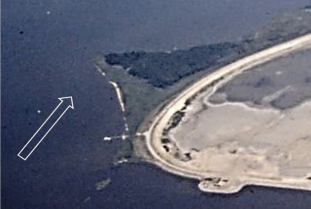
Surprise! They’re back! An old tire reef, or at least vestiges of it, reappeared southwest of Hart-Miller Island after years of burial in a bed of muck. There’s not much information available about this reef, other than it was put in decades ago. A newspaper report from way back mentions that William “Bill” Huppert had something to do with building it. According to the newspaper article, Bill said 3000 tires were deposited, but they were soon covered by sediment. The exact location wasn’t given. The reef was before my professional work with Upper Bay dredging, and it never was mentioned during my nearly 10 years of association with Hart-Miller Island when it was an active dredged material containment facility.
During my time with Maryland’s artificial reef program, Bill championed bringing reef balls into the environmental education program sponsored by the Perry Hall Chapter or the now defunct Maryland Saltwater Sportfishing Association (MSSA). I had the good fortune while serving with the Maryland Environmental Service (MES) to support his effort. The collaboration was in conjunction with MES efforts to introduce reef balls to the state’s oyster restoration and artificial reef programs. Bill participated in the first reef ball pour training that was held on Tilghman Island in 2004. The event was jointly sponsored by MES and the Oyster Recovery Partnership, and was opened to groups who were involved with Bay restoration. Later, Bill and I collaborated on posters for reef ball pours which became a centerpiece of his MSSA chapter’s environmental education program with middle school students. A huge number of low-profile reef balls produced over the years by students were placed at Memorial Reef in the Upper Bay.
Fast forward to July 2019. About 200 unidentified low-profile objects popped up on a recreational boat sonar southwest of Hart-Miller Island. Sonar images suggested holes in the middle of the units. The boater, referred to me, asked, “Are they reef balls?” I couldn’t help him, there was no record of reef balls there in my rat-pack pile of reef data, so, I asked MES. They checked with the Maryland Port Administration (MPA). After checking their files, neither found anything about reef ball placement off Hart-Miller in the Hawk Cove area. Could it be the old tire reef?
Thinking about this situation, when the tire reef was deployed Hart-Miller Island stretched almost across to Pleasure Island to the south (they were once connected). So, wave energy from the Bay didn’t make it into Back River. This resulted in protected water conditions that favored sedimentation that covered the tire reef. As the neck eroded, the gap became wider. It also became deeper with more water movement through it. Then, there was a huge tidal surge discharge and significant wave energy turbulence during Tropical Storm Isabel. Bottom that was protected from physical wave energy before was now exposed to it. With the anecdotal report of round circles off Drum Point, it appears that conditions had changed sufficiently for currents to sweep away disturbed sediment that previously covered the tires. Turbulence from Isabel and other storms might also have displaced tires that were uncovered.
Whether or not the exposed tires have developed as a fishing hotspot is uncertain. Even so, add it as another spot to check for Upper Bay light-tackle fishing when working along the Hart-Miller Island shoreline. Also cast to the extensive riprap that was installed around Pleasure Island, particularly where the current is moving. A good protected launch for fishing the Back and Middle River shorelines is located at Baltimore County’s Rocky Point Beach and Park in Essex. There are a number of other county launch ramps to choose from as well.
Poking and Prodding Around the Patapsco River
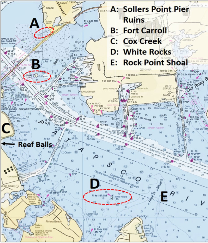
There is also very interesting structure to check out in proximity of and inside the mouth of the Patapsco River, especially on days when the main stem Bay is cranky. In addition to Baltimore County launch ramps, the launch ramp at Anne Arundel County’s Fort Smallwood Park is well positioned for trailer boaters who want to fish this area. The entrance to the ramp is open to the northwest, but there is a breakwater and the layout of the ramp provide some protection right at the ramp if northwesterly winds are blowing. Shoreline anglers: the park also features a very nice, long fishing pier. Immediately northeast of the ramp is the Rock Point Shoal (E). The edge along the eastern side quickly drops off about six to eight feet.
North northwest of the Fort Smallwood ramp is a very large natural formation known as White Rocks (D). Some of the sandstone rocks are over 25 feet high. Submerged rocks surrounding the large rocks extend out 150 feet or so to the north, about 100 feet to the northwest, and 50 feet or more to the east. Some of the rocks can be seen as shadows under the surface on satellite images. Checking these images before attempting to fish the structure is a good idea. The structure regularly holds perch, and foraging stripers are also a possibility.
Northwest two and a half miles from the rocks is the Cox Creek Dredged Material Containment Facility (C). The dike is protected with riprap, offering light-tackle casting opportunities. This is an active facility. Stay clear of tugs and barges delivering dredged material. A long line of reef balls several rows wide is along the shoreline at the southeast corner of the facility. It is very shallow in there, best fished by kayak at high tide.
Other structure in the outer Patapsco River to check include the pier ruins at Sollers Point (A) immediately west on the north side of the Key Bridge and Fort Carroll (B). The Sollers Point ruins extend out 200 yards or so from the shoreline. Satellite images show thick bands of material along sections of both sides of the structure. The image suggests possible rock with rows of piling extending the full length of the structure. Along the southeastern shore of Baltimore County, structure to check includes the Ferry Grove Pier ruins, about a four-mile run from White Rocks. Water by the pier is shallow, but there is access from the east to the three sunken barges that close off the entrance to this old excursion landing (see “Bridges Under Troubled Waters” for a layout drawing).
Five and a half miles east northeast of White Rocks is the well-known Man-O-War Shoals. Look for perch and foraging stripers. A four-mile run from there to the northeast is Bill Huppert’s Reef at Memorial Reef, and a huge number of reef balls on top of processed concrete rubble from Baltimore’s Memorial Stadium. Construction of Memorial Reef was sponsored by the Maryland Department of Natural Resources. Rubble from the dedication facade of Memorial Stadium was processed into softball- and football-sized chunks and placed as foundation material at the reef site. Most of the substrate was placed using a water canon to wash material overboard resulting in a fairly even bottom. Some of the rubble was also placed using a bucket crane, resulting in some low mounds. Ninety “Bay” balls (medium size reef balls) were placed in 2002 as a field test, some with oyster spat attached at the Horn Point oyster hatchery. The Chesapeake Bay Foundation’s Patricia Campbell placed the first installment of smaller low-profile balls that were produced by the middle-school students. That number grew enormously over the years through the efforts of Bill Huppert and his Perry Hall chapter colleagues
Two years after placement, the MES reef team lowered a drop camera to the bottom to monitor reef ball performance. We found the reef balls heavily colonized by marine organisms, mostly muscles, but also barnacles, anemones, and hydroids. Water clarity was marginal during our inspection, but we were able to observe schools of small predators cruising along the bottom between the reef ball clusters. Best assessment was that they were croakers by appearance. There was also a catfish, and a fleeting glance at what could have been small stripers in a few frames. This reef site is definitely worth a look when passing through the area.
Author Wayne Young is the author of “Bridges Under Troubled Waters: Upper Chesapeake and Tidal Potomac Fishing Reefs,” and “Chesapeake Bay Fishing Reefs, Voyage of Rediscovery.” Both are available at Amazon, and you can find his Facebook page at Chesapeake Bay Fishing Reefs. Look for his new books, “Phantoms of the Lower Bay” and "Hook, Line, and Slinker."
Sign up here to get the weekly FishTalk Chesapeake Bay and Mid-Atlantic fishing reports in your email inbox, every Friday by noon.