At 17.6 miles long, the Chesapeake Bay Bridge-Tunnel, known as the CBBT, is the largest artificial reef structure in our region. The entire structure is fishable, though some spots more so than others. Environmental and physical conditions vary widely from one end to the other, and can change very quickly. Fishing this structure isn’t for the inexperienced or the faint at heart, and you must be prepared for strong currents interacting with ocean swells. Plenty has been written about how, where, and when to fish the legendary Bridge-Tunnel structure (see more how-to/where-to fishing articles on the CBBT, to get your fill). Can’t add anything there. However, gleaning a few details derived from National Oceanographic and Atmospheric Administration’s (NOAA) side-scan sonar images can be instructive. Although NOAA’s Bathymetric Data Viewer (BDV) only partially covers the complex, both of the main channel openings (locations “C” and “D”) are included.
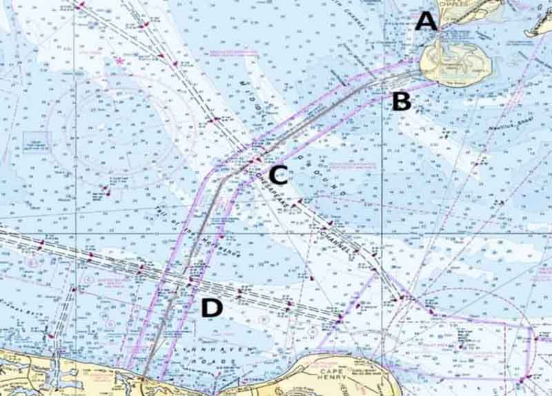
Starting from north to south, the bridge across Fisherman Inlet at location “A” connects the highway to the causeway on Fisherman Island. A small inlet at the island near the bridge was the location for an experiment using fly ash from a coal-fired power generating plant as a resource for oyster bed restoration. During my dredged material management days for the Port of Baltimore, we looked into recycling dredge material and combining it with fly ash and cement to create solidified material for various uses including mine reclamation. So, this early use of stabilized fly ash for oyster restoration was intriguing. The fly ash was mixed with cement to create pellets that became substrate for oyster beds. Analysis of the product showed that constituents in the fly ash were locked into the structure and did not pose an environmental risk. The oyster restoration project was successful and the bed is still there growing oysters today.
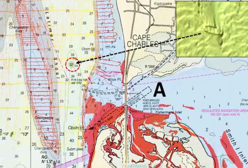
The northern approach bridge is mostly outside NOAA side-scan sonar coverage. BDV side-scan sonar coverage extends around much of the island, though. A small area of coverage under the bridge on its south side is unremarkable. The wreck of a 55-foot boat recorded in AWOIS and charted as a wreck at the southwest end of the spoil area is not visible in the BDV image. If it’s still there, it is likely covered with sediment. The frame of a small charted wreck northwest of the bridge, however, is visible in the image. It’s located right in the middle of the Virginia Inside Passage east of Latimer Shoal. Although not very big, it’s a spot worth checking.
Water depths and an access channel on the bridge’s west side allows approach by small boats. Outside the channel east of the span is very shallow. A charted obstruction is south of the channel, just west of the bridge. NOAA’s Automated Wreck and Obstruction Information System (AWOIS) records that landing craft used to hang up on an object in this general area.
The Virginia Inside Passage channel runs under a fixed bridge at location “B.” There are several nearby uncharted bottom anomalies and an obstruction. All are small in size and potential objects on which end tackle could hang up.
The island at the northern and southern ship channel openings, locations “C” and “D,” are very similar structures but bottom conditions in the channels vary substantially. In particular, rock protection above the tunnel connecting the islands at “C” is exposed on the bottom, which is very rugged. The BDV image shows what is probably a large scour area on each side of the protective rock. The channel ends of each island where the tunnels rise back to the surface are heavily riprapped. A cluster of obstructions lay off the southwest corner of the southern island. None of these objects are described in AWOIS. The southeast obstruction is a large group of small objects. The other two obstructions are single objects. All are worth checking out when fishing around the southern island.
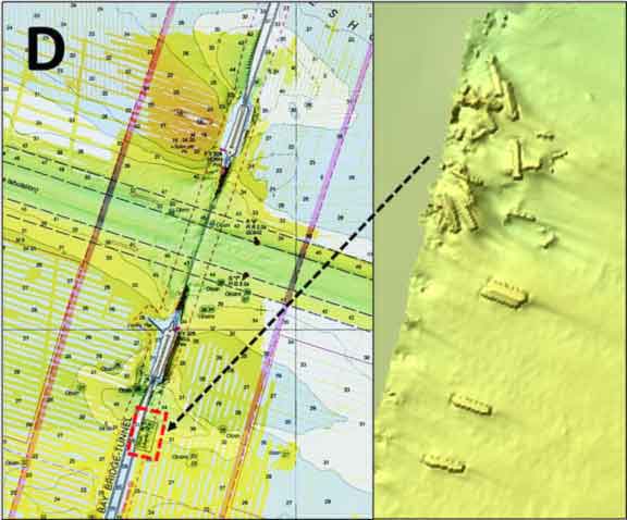
Rock protecting the tunnel connecting the islands at the southern channel opening, location “D,” is below the mudline. As at location “C,” the channel ends of each island where the tunnels rise back to the surface are heavily riprapped. Alongside the causeway immediately south of the island on the east side is a charted obstruction. The objects within the obstruction boundary resemble an artificial reef. However, it wasn’t constructed. A 400-foot Navy amphibious supply ship, the USS Yancey, dragged anchor during heavy winds in 1970. The ship struck the bridge, opening a gap in the roadway. Debris from the collision including bridge sections are scattered on the bottom. The debris field is certainly worth a peek, when fishing this island.
The wrecks and obstructions discussed above are but a few of the many located in and near the entrance to the Chesapeake Bay and the Bridge-Tunnel, not to mention its 5114 pilings. Several substantial wrecks are also nearby, fishing reef stories for another day.
-By Wayne Young. You can find Wayne's books, “Bridges Under Troubled Waters: Upper Chesapeake and Tidal Potomac Fishing Reefs,” and "Chesapeake Bay Fishing Reefs: Voyages of Rediscovery," at Amazon.com. You can find his Facebook page at Chesapeake Bay Fishing Reefs.
Sign up here to get the weekly FishTalk Chesapeake Bay and Mid-Atlantic fishing reports in your email inbox, every Friday by noon.