The Chesapeake Bay entrance is best known for its fishing at the CBBT, but there's far more structure through this area than many anglers realize.
Coast Guard Cutter Eagle, the Service’s 295-foot square-rigged barque, was standing into Chesapeake Bay under full sail. It was the late 1960s, and I was the first-class cadet coxswain of the watch. My duty: carry out steering and course orders from the cadet officer of the deck. My specific task was directing third-class cadets who were manning the ship’s helm. Although there was only a slight swell and mild breeze, we were in a busy shipping channel. So, four cadets were at the helm to respond rapidly to rudder commands. Cadets performed under the watchful eye of a commissioned officer, and when the situation demanded, the ship’s captain.
Lessons from these experiences proved helpful in my later seagoing service. Applying what I learned saved my butt (and vessels from mishaps) more than once during difficult operating conditions. But, these were future events. And I couldn’t have imagined that some 60-plus years later I would be writing about natural and artificial fishing reef structure in and around the Bay entrance where I had once stood watch.
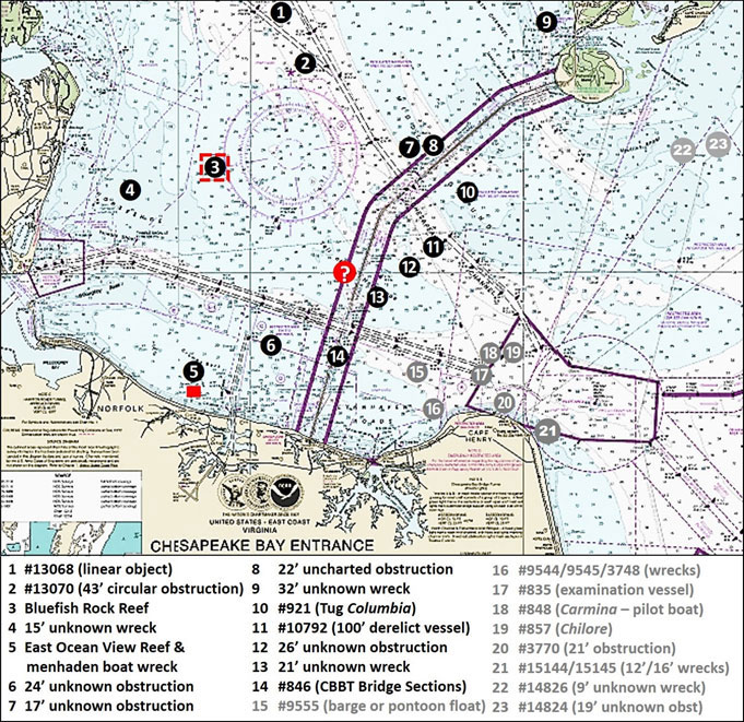
The mouth of the Chesapeake Bay has always been a hub for maritime commerce, commercial fishing, and naval activity. It’s also a huge inlet with massive flows of water in and out where the Bay meets the ocean. Little wonder that the Bay Entrance became a naval hunting ground during wartime and a graveyard for vessels and cargoes lost to natural conditions and marine casualties. The area is also the final resting place of deliberately placed bottom structures intended to serve as marine habitat and sportfishing grounds. Sites #1 through #14 are discussed here, and the remaining sites will be examined in Part II of Bay Entrance Fishing Structure, in next month’s edition of FishTalk.
The Chesapeake Bay Bridge Tunnel (CBBT), which spans the western side of the entrance is longer than the run to get there from many Tidewater marinas and ramps! And there are some spots to check on during that run. A few are included on Chart 1. For example, Site #1 is a “40-foot obstruction,” hydrographer jargon that means the charted “least depth” is 40 feet. Generally, hydrographic surveys conducted from the mid-2000s forward involved the use of multibeam sonar. The data was used to create Bathymetric Attributed Grid (BAG) Color Shaded Relief images found using the Bathymetric Data Viewer (BDV). This imagery, where available, provides additional details that help us understand what is on the bottom and how it is configured. In the case of Site #1, both BAG Color Shaded Relief and color multibeam sonar images show a feature resembling a dredge pipe that is broken into sections, which is about 125 feet long, and appears partially buried.
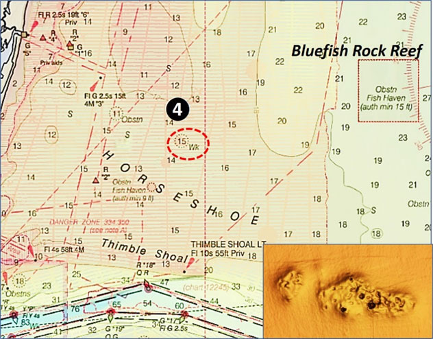
Site #2 is a 43-foot obstruction and was investigated by divers who found a sunken circular mooring buoy with a 1.5-meter diameter. The BAG image shows the obstruction lying in a scour hole. Although charted, this structure would be hard to find and difficult to hold over. Better for the angler will be Bluefish Rock and Bluefish Rock Reef (Site #3). The latter is one of the newer Virginia Marine Resources Commission (VMRC) artificial reefs. The materials and layout of this reef are presented in “Chesapeake Bay Fishing Reefs: Voyages of Rediscovery.” Look for distributed wreckage at Site #4 (Chart 2). Shown by a BAG image, it is widely dispersed wreckage lying in two scour holes. Overall length is about 200 feet with a maximum width of about 50 feet. Although there’s not a lot of structure here, the configuration looks like a good spot to prospect for spot, croaker, and flounder.
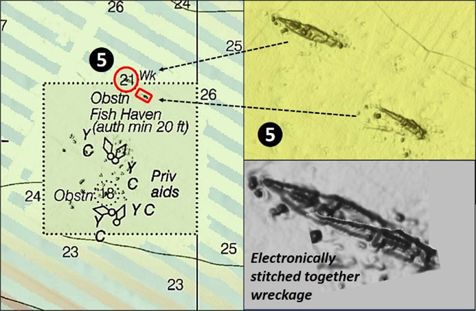
Moving southeastward past Willoughby Spit to East Oceanview brings us to East Oceanview Fish Haven, Site #5. This VMRC reef was the site of an early reef material field experiment using junked automobile bodies. A lot of material has been deployed there since. The experiment, reef materials, and layout are presented in “Chesapeake Bay Fishing Reefs.” There is one wreck of particular interest, a menhaden boat broken into two pieces. The 21-foot wreck just north of the fish haven boundary is the front half of the fishing vessel. This section is about 120 feet long. An object that by appearance is the back half of the boat, about 75 feet long, is inside the reef boundary. The two sections are electronically stitched together on Chart 3. Intact, the vessel would have been a large trawler about 150 feet long.
Site #6 is a small, 24-foot obstruction. The BAG image shows five small objects with three of them appearing as if covered with sediment. There are several more tempting obstructions along the northwest side of CBBT Trestle C. The largest, Site #7, is a charted 17-foot obstruction. The feature is about 150 feet long and 30 feet wide. Multibeam sonar images show very rugged features, with a configuration suggesting a deteriorating wreck, perhaps a sunken barge or the cargo that was aboard. Site #8 is about 100 feet long and 10 to 15 feet wide. It consists of several clusters of small objects lying in small scour holes.
A 32-foot unknown wreck at Site #9 lies to the north. The BAG image shows what presents as the gunwales of a small vessel. The eastern end appears to be broken off and lying in a north-south scour hole. Using the BDV distance scale suggests a length of about 60 feet and a width of 15 to 20 feet. Although relatively small, it and the surrounding area may be worth a few drifts for bottom fish.
Site #10 is the wreck of the 65-foot tug Columbia, lying in a scour hole. A 100-foot deralict vessel is at Site #11. The AWOIS entry reads: “Wreckage consisted of two large metal boxes, wooden remains of a ship, and a metal pole protruding out of a sand bottom…”
Site #12 is a 26-foot obstruction. Two sections are lying in a scour hole. It’s possibly a deteriorating wreck. The feature has a length of about 62 feet and width of 20 feet and is oriented northwest-southeast. Site #13 is a 21-foot unknown wreck. BAG, side-scan sonar, and color multibean sonar images all are in close agreement, showing the outline of an unidentified vessel with a few broken-off bulwark sections lying alongside. The interior is filled with sediment. This is another wreck to try for spot, croakers, and flounder, and there might be some tautog here as well.
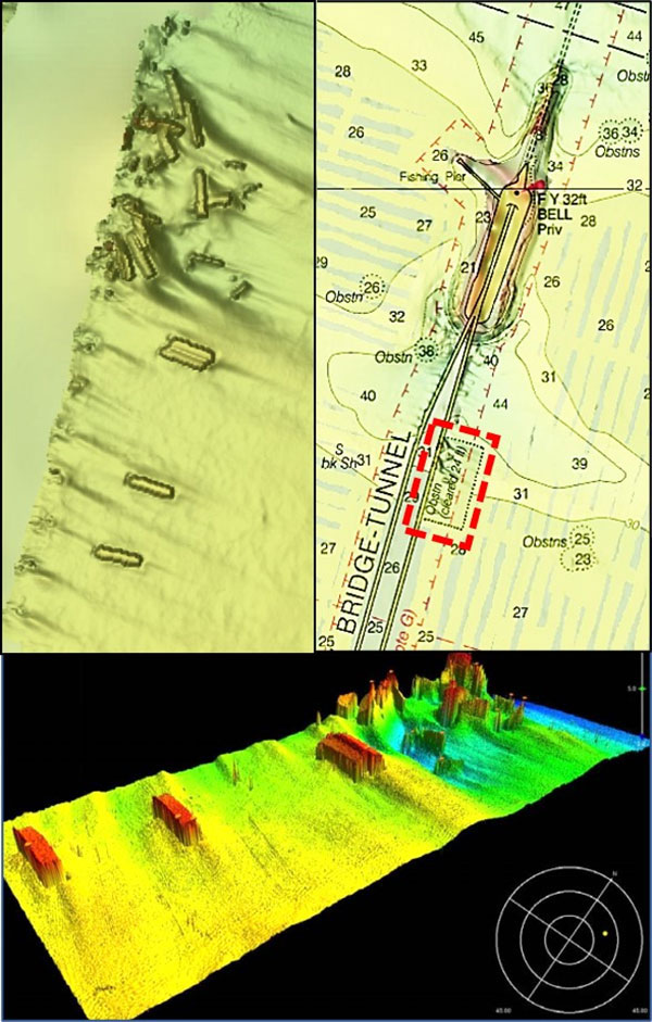
Site #14 is, in effect, an unintended artificial reef. It consists of bridge sections broken off from the CBBT trestle when a Navy ship dragged anchor and collided with the bridge in 1970. The reef lies alongside the eastern side of CBBT Trestle A, as shown in the color multibeam sonar image (Chart 4). There’s plenty of structure here to check, and multiple species should be in attendence at any given time.
Moving north to Trestle B there is additional structure to consider. About a mile north of the shipping channel is a charted 11-foot wreck under the southbound trestle. There are conflicting accounts of what is there, so it’s shown as a questionmark on Chart 1. The feature was investigated with side-scan sonar and by a diver in 1983. Reports are that the diver identified a steel pile driver that rose 15 feet off the bottom on a crane barge measuring 30 by 20 feet. The barge rose about two feet off the bottom. AWOIS records the name as Big D and states that the size is 70 feet by 150 feet, an obvious conflict with the DR data. “Gary Gentile’s Popular Dive Guide Series: Shipwrecks of the Chesapeake Bay in Virginia Waters” (Gentile, 2014), reports that the wreck is the William Donnelly, a wooden schooner that went down with a cargo of 155 tons of coal in 1914. Gentile records that the wreck was demolished with explosives by a U.S. Army Corps of Engineers contractor in 1915.
Which account is correct? We can’t say, but in any case, the feature is worth checking out when fishing in and around the CBBT.
Structure in the vicinity of the CBBT is varied and plentiful, providing a range of fishing opportunities for diverse species. If the fish aren’t biting at the CBBT, head out the channel or over to Cape Henry where a cluster of wrecks and obstructions beckon.
Editor's Note: For details on the rest of the hotspots shown on the chart, see Chesapeake Bay Entrance Structure, Part II.
- By Wayne Young. As well as being a regular contributor to FishTalk, Wayne Young is the author of multiple books detailing wrecks and fishing reefs in the Chesapeake Bay, Delaware Bay, and beyond. All are available at Amazon.com, and you can find his Facebook page at Chesapeake Bay Fishing Reefs.