A varied array of natural, accidental, and artificial reef building bottom features marked by blue circles on Chart 1 are available for sportfishing off the southern end of the Delaware – Cape Henlopen Traffic Separation Scheme (TSS). There are two popular wreck fishing hotspots inside the lower end of the TSS. First look for “Patty’s Pitcher Wreck” at Site 13. It’s a 93-foot-deep wooden wreck at coordinates 38’30.146 x 74’43.779. The feature is documented as File Number 10399 in the Coast Survey’s Automated Wreck and Obstruction Information System (AWOIS). The wreckage is described by divebuddy.com, a diver website, as “...mainly a series of ribs with lots of nooks and crannies for bugs and fish to hide. The bow sports a large anchor and pony boiler out in the sand. The stern has a large rudder flat on the sand. Several gudgeons have been brought up in the last few years. She is also thought by some to possibly be the Singleton Palmer, sister ship to the Elizabeth Palmer.” A wreck that is low profile or distributed on the bottom doesn’t mean that it won’t attract sportfish, as we’ll see with the following wreck site.
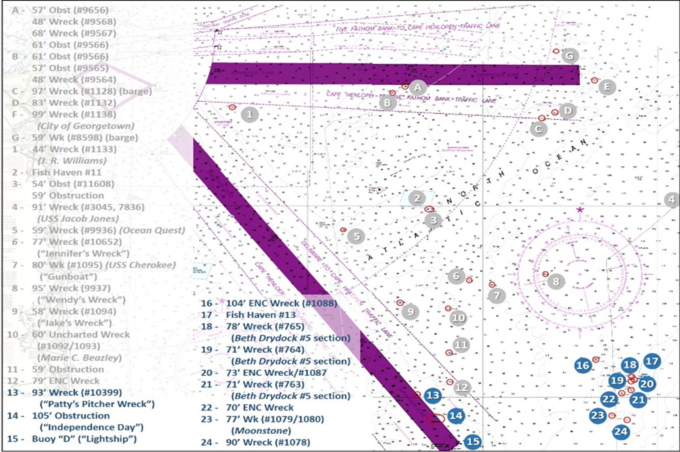
North of the southeast end and just inside the eastern edge of the TSS Separation Zone are 105-foot obstructions marked as Site 14. This is an unidentified shipwreck known as the “Independence Day” wreck and also the “Bimbo Wreck.” BAG imaging shows a large object, but not with much detail. However, high-definition sonar scans by Ben Roberts, Eastern Search & Survey (ESS), reveal a low-profile distributed wreck that is about 240 feet long and 38 feet wide. Back in 1921, the five-masted wooden schooner Singleton Palmer sank following a collision some 10 to 13 nautical miles from Fenwick Shoal Lightship. This wreck is a bit shorter than the Singleton Palmer, although it’s in proximity to where she went down. This wreck, located as it is in the bottom of the old riverbed, is a fish magnet, especially for sea bass and tautog. The ESS scan shows the wreck literally covered with fish — don’t pass this one by!
The southern end of the TSS (Site 15), is marked by Delaware Lighted Buoy “D,” formerly “DL.” This was the location of the Delaware Lightship, and the location is commonly referred to by that name. The bottom here is quite irregular and is a flounder and sea bass hotspot.
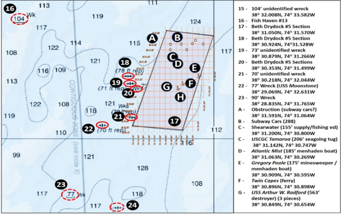
When running offshore, it’s nice to have multiple fishing spots to prospect. Sites 17 through 24 are located in the same general area and include Delaware State Fish Haven 13. Coordinates in the following narrative and positions shown on Chart 2 are based on best available information including the Navionics electronic chart community layer and reef program, diver descriptions, and underwater and historic pictures which are available online for some of them.
Site 16 is a 104-foot-deep wreck at coordinates 38’32.008 x 74’33.582. Site 17 is a general marker for Fish Haven 13, the Del-Jersey-Land Inshore Site, where substantial artificial reefs were deployed. These include 288 subway cars as well as fishing vessels, the 563-foot-long destroyer USS Arthur W. Radford (broken into three pieces), and the 206-foot-long USCGC Tamaroa of “Perfect Storm” fame. The relative locations of the deployed reefs are shown on Chart 2. The Delaware State reef program grid drawing was superimposed over a nautical chart and then manipulated into alignment with geographical coordinates. This is an active reef site, and additional reef deployments may occur. The subway cars are in six 44-unit clusters and one 24-unit cluster. Coordinates can be found in the program reef guide that is accessible online.
In the movie "The Perfect Storm", a modern-looking, high-sided Coast Guard cutter portrayed the Tamaroa. Had it been such a cutter, it would have been much more difficult, if not impossible, to do what the officers and crew of the Tamaroa did. The actual cutter was a high bow, low sided seagoing tugboat — a workboat configured to work alongside another vessel. The low sides facilitated the rescue of persons onboard the distressed sailboat under horrendous sea and wind conditions. I suppose the low profile, ancient mariner look wasn’t appealing enough for either the movie screen or the Coast Guard. Too bad. Showing what the actual ship looked like would have conveyed what the Coast Guard historically has often had to work with: old ships past their planned service life.
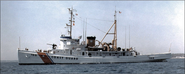
The first cutter I served on right out of the Coast Guard Academy in 1968, the Acushnet, was a former Navy seagoing salvage tug, then over 20 years old. The venerable ship was still in service three decades later in Alaska when a propellor sheared off due to metal fatigue. The Coast Guard tried unsuccessfully to find a replacement prop in museums.
Sites 18, 19, and 21 are from a six-section Bethlehem Steel wooden drydock. The drydock had massive two-foot by two-foot square timbers. It was deployed in 1985 in the general vicinity of Del-Jersey-Land. AWOIS records that each section is 133 feet long by 96 feet wide by 54 feet tall.
Site 20 is an unidentified 73-foot-deep wreck at coordinates 38’30.879 x 74’31.266, and site 22 is a 70-foot-deep (also unidentified) wreck charted at coordinates 38’30.218 x 74’32.044. Site 23 marks the USS Moonstone at coordinates 38’29.068 x 74’32.633. The vessel was a 171 foot long by 26-foot-wide private yacht that was converted into a Navy patrol craft during World War Two. It was lost following a collision with a destroyer in 1943. A picture of the vessel in better days and an underwater picture of the heavily encrusted deck gun are posted on njscuba.net, a great diver website and information resource. The website reports that the vessel is upright and intact except for a large hole in her port side and collapsing midsection superstructure. Depth charges still in the racks are also reported, though structural conditions are likely to have deteriorated from those indicated. Southeast at Site 24 is a 90-foot wreck at coordinates 38’32.008 x 74’33.582. With position errors in contemporary reports of up to a nautical mile and a date given as one month after the Moonstone sinking, Site 24 could also be describing the same feature.
Remember that older wooden wrecks, like many of these, are fragile and can be easily damaged when anchors fouled in them are forcibly removed. Damage accelerates the loss of both archeological value and fishing reef structure. We should respect wrecks when fishing them and attempt to avoid damage that could shorten their lifespan. Plus, anchoring directly in them runs the risk of losing an anchor. Using a wreck anchor that bends out, or anchoring off of the wreck itself, is a better move.
Editor’s note: Anglers fishing DE coastal waters will also want to see the first installment of this series, Delaware Ocean Structure Part I: East of Indian River, and the final installment, Delaware Ocean Structure Part III: Cape Henlopen.
- By Wayne Young. As well as being a regular contributor to FishTalk, Wayne Young is the author of multiple books detailing wrecks and fishing reefs in the Chesapeake Bay, Delaware Bay, and beyond. All are available at Amazon.com, and you can find his Facebook page at Chesapeake Bay Fishing Reefs.
Sign up here to get the weekly FishTalk Chesapeake Bay and Mid-Atlantic fishing reports in your email inbox, every Friday by noon.