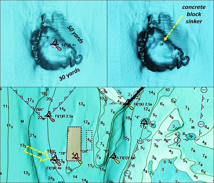
Striped bass, redfish, and cobia seem to hang out around navigation buoys and markers — or, at least that’s how we ID the area they’re in. How often have we heard in fishing reports that fish are at a certain buoy? But why are they there? Do fish like buoys? Marine growth on navigation markers and buoys sometimes does attract bait, and bait attracts predators. Certain fish (particularly cobia) may also suspend under floating objects in ambush or for cover. Even so, buoys, buoy chains, and buoy sinkers are generally not particularly attractive by themselves. The primary draw that pulls in baitfish and predators is what exists or is happening around buoys, and what they’re identifying. For example, a buoy may be marking a shoal, outcropping, or wreck. A big secondary draw, however, can be huge “buoy holes” scraped and scoured out under the buoy sinker, such as shown for Chesapeake Channel Lighted Buoy 78 on Chart 1 off the southwest corner of Dominion Reef at the Gooses.
Although I’m a former Coast Guard buoy tender sailor, I had no idea about the extent of some of these scrape and scour holes until discovering Bathymetric Attributed Grid (BAG) depictions of bottom structure while exploring features using NOAA’s Bathymetric Data Viewer (BDV).
The size of many buoy holes displayed by the BAG data layer is shocking, not so much because the sinker is in a hole, but because the sinker has moved around so much. That means the buoy is ranging a lot father away from its charted position than I would have thought. This movement could be significant depending on what the buoy is marking, especially if you’re trying to use it as a visual frame of reference. And there’s no way of telling from the chart which buoys are over large holes or how large the holes are.
Why are the buoy holes so large? What we’re seeing are scour holes from currents sweeping around the huge concrete blocks the Coast Guard uses as a sinker, to hold a buoy in place. But on close inspection, there’s more going on. The sinkers can move around; my best guess is that the combination of strong winds and currents during episodic storms stretch the buoy out on its chain and then storm-generated waves lift the buoy causing the sinker to hop. Since buoys have marked the same locations for decades, and in some cases over a hundred years, the effects of the sinker hopping and scrapes and scours are cumulative.
Buoy holes aside, aids to navigation mark features and hazards important to navigation such as small boat and shipping channels, shoals, obstructions, ruins, and wrecks. These various features can interact with local physical conditions, especially current, to attract or funnel bait or provide foraging opportunities for predators, and are the primary reason fish are often found near buoys.
Chesapeake Lighted Channel Buoy “72A” on Chart 2 provides a multi-feature example. It’s located at the southwestern corner of a broad shoal area that once was the end of a peninsula on the north side of the ancient Honga River entrance. On a rising tide the flood currents run into and are disrupted by the protruding subsurface shoal, creating turbulence favorable to foraging by predators such as striped bass and redfish. The area around and east of the buoy where there is a long slough are trolling hotspots from spring through fall and jigging spots in the fall and winter when fish are deep.
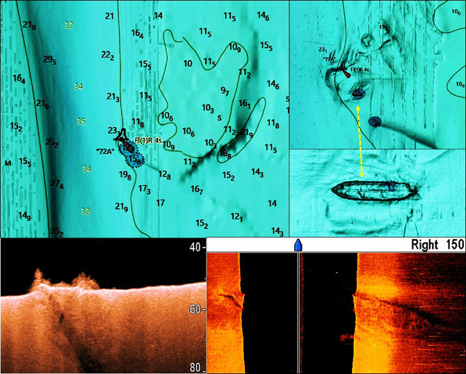
There’s also an unidentified 42’ wreck just southeast of the buoy at coordinates 38’09.926 x 76’13.491. The BAG and sonar scans I took show bulwarks and keel or keelson of what is mostly likely a wooden wreck. It measures about 170’ by 35’ on the BDV scale and rises several feet off the bottom. There appears to be a protrusion that sticks upward perhaps five to eight feet in the center of the southern bulwark. Captain David Howe, Institute of Maritime History, and owner and skipper of the dive boat Roper, believes this is the schooner barge Tuckahoe which foundered in 1949. If so, its actual length is 179 feet.
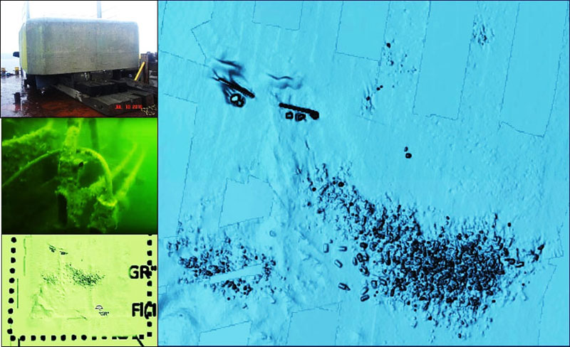
We see another example by returning to Chesapeake Channel Lighted Buoy “78” on Chart 1, marking the edge of the deepwater channel off the southwest corner of Dominion Reef at the Gooses. Here the buoy hole is a minor feature compared to the natural bathymetry and the artificial reef. The shoal edge is a traditional trolling hotspot. But don’t try trolling over the reef structure unless you like to snag and lose lures. Jigging is an option but expect to lose some as well. Most of the reef deposits consist of Wilson Bridge demolition material that was dumped across the bottom as shown by Chart 3. The northern two reefs are materials donated by Dominion Energy and the large block-like objects on the bottom are dolphin caps that were deployed in 2010.
- By Wayne Young. As well as being a regular contributor to FishTalk, Wayne Young is the author of multiple books detailing wrecks and fishing reefs in the Chesapeake Bay, Delaware Bay, and beyond. All are available at Amazon.com, and you can find his Facebook page at “Chesapeake Bay Fishing Reefs.