The middle portion of the Potomac River offers multiple fishing destinations. In this advance preview of my forthcoming exploration of tidal Potomac River structure, we’ll look at the Virginia side of the river from the Harry W. Nice Bridge to Church Point south of Dahlgren. General locations for structures in this reach of the river and tributaries are indicated on Chart 1.
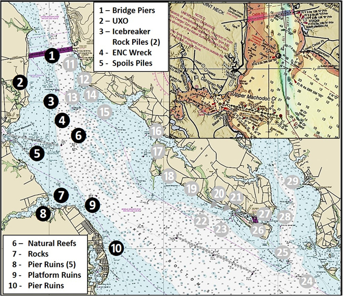
The first fishing hotspot consists of the Harry W. Nice Memorial Bridge piers, Site 1 on Chart 1. An ongoing bridge replacement project has made the piers unavailable for fishing recently, but bridge construction is now completed. Bridge piers are instantly a fishing hotspot because of hydrodynamic effects that are only increased over time as biofouling by marine organisms enhances habitat value. Current piling up against the leading edge of a structure creates a downward current vector that delivers bait to the base. Bait is also swept down each side especially along the base. This is why we target the base of the up-current leading edge and sides of a bridge pier or similar structures. Predators may also be in the eddy on the down-current part of the pier, but fish in this position may be resting rather than actively feeding. Popping a jig in front of them might provoke a reaction strike. As an aside, major demolition components from the bridge are slated for artificial reef construction in Bay waters in the general vicinity of the mouth of the Potomac and perhaps in the river as well.
Site 2 is a general marker for the Naval Surface Warfare Center (NSWC) at Dahlgren, VA. Permanent restrictions that are always in force include a prohibition from approaching within 100 yards of NSWC Dahlgren due to the known presence of unexploded ordinance (UXO).
Winter ice was a threat to navigation markers south of the 301 Bridge to well below the Kettle Bottom Shoal well into the 20th Century. Site 3 consists of icebreaker rockpiles on the upriver and downriver side of the green 33 marker. It marks the steep edge on the west side of the deep-water trench. Check both rockpiles for stripers. Site 4 is an Electronic Navigation Chart (ENC) wreck at approximate coordinates 38'19.699 x 77'59.141.
Site 5 is a discontinued spoil area on the south side of Upper Machodoc Creek. Elongated mounds parallel the channel. The nautical chart shows rocks about coordinates 38'18.422 x 77'00.392. There are also elongated mounds on the north side of the channel. These may also be spoils. Water depths are charted as two to five feet. Numerous submerged stakes, dolphins, and pilings are shown on either side of the channel, posing dangers to navigation. When fishing such areas, my practice is to run parallel to the feature and assess where to go and what to avoid with my side-scan sonar. Then, I’ll progressively step my way in. For the rocks in the discontinued spoil area, I’d approach the charted location from the south to minimize exposure to the submerged stakes and dolphins.
Site 6 at coordinates 38'18.835 x 76'58.849 marks the north end of Kettle Bottom Shoals. They impeded the British fleet that was headed upriver to raid Washington during the War of 1812; the extensive oyster reefs were much higher then, and close to the surface. The area was also known for the so called “oyster wars” between Maryland and Virginia watermen. Extensive oyster reefs were worn down, in many cases to flat, by oyster dredges. So, the shoals are much less formidable than back during the era of sail, but there are still many humps and mounds.
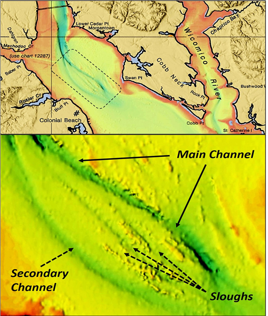
The top graphic of Image 1 shows the BDV “DEM” Color Shaded Relief layer for an area-wide view of bathymetry between the Route 301 Bridge and St Catherine Island, and also the Wicomico River. The portrayal of bathymetric form shows us that the most rugged bottom extends from lower Cedar Point south the Swan Point. The bottom graphic is a closer zoom for this spot. A look at the large, broad mound between the south end of the deep-water trench and Swan Point shows two channels and three sloughs oriented upriver-downriver, providing natural trolling lanes. There rugged bottom at the south end of the mound offers jigging opportunities. Also try trolling across the sloughs angling down-current.
On the Virginia side at Site 7 is a massive area covered by rocks at the aptly named Stony Point. These rocks may be uncovered at low tide and extend out from the shoreline, forming a rounded point. Beyond that to a distance of about 200 feet offshore are scattered rocks. The water depth is very shallow here and topwater lures or shallow-running swimbaits would be good choices to minimize snags. Due south of Stony Point there is a spit that curls towards the west through two small islands. The southernmost island is King George Point. The waters on the river side are very shallow but offer foraging opportunities when stripers are feeding shallow.
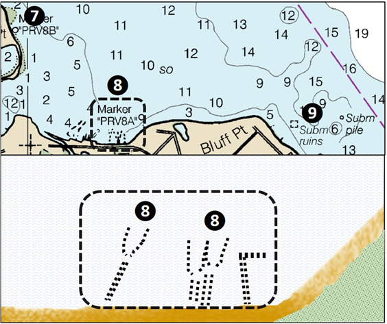
About 1200 yards west of the point is a little cove at Potomac Beach. Excursion steamers landed passengers here for visits to Colonial Beach, and extensive pier ruins are still there at Site 8. Some of the pilings are visible above the surface, but when viewed from sea level, are insufficient to show the configuration of the wing walls. Google Earth imagery shows the feature and also shows one “L” shaped pier and four small piers, all in ruins. The “L” pier is a more recent ruin, and is shown as intact by 2006 historic imagery. Two hundred yards southeast of Bluff Point, Site 9 marks the charted ruins of a submerged platform.
Further south along the Colonial Beach waterfront at Site 10 are more pier ruins. They were platforms for former Maryland gambling sites. Under the 1632 charter to Lord Baltimore as interpreted by the courts, the Maryland boundary was at the low water mark along the Virginia shoreline. Between 1949 and 1958, five slot-machine casinos built on wharfs on the Maryland side of the line were accessed by piers extending out from the Virginia shoreline. Riverboat floating gambling houses also operated from piers in Virginia, until changes to Virginia and Maryland laws eventually closed the casinos and riverboats. Hurricane Hazel took out one of the gambling house piers in 1954, and in 2003 Tropical Storm Isabel severely damaged other waterfront structures. Gambling still takes place at these locations today — but in the form of anglers tossing their lures or jigs into the snaggy structure, to see if something with fins takes the bait!
- By Wayne Young. As well as being a regular contributor to FishTalk, Wayne Young is the author of multiple books detailing wrecks and fishing reefs in the Chesapeake Bay, Delaware Bay, and beyond. All are available at Amazon.com, and you can find his Facebook page at Chesapeake Bay Fishing Reefs.