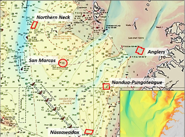
Geologically, Chesapeake Bay fishing means navigating above what is a drowned river valley that developed over several million years. There were four major outlets to the ocean that preceded the current Chesapeake Channel. Today’s eastside deep-water channel (shown in Chart 1) are vestiges of the former Susquehanna riverbed.
Six to seven thousand years ago, the water level was about 30 feet lower. Natural processes of erosion, littoral drift of sediment along the coast, and sedimentation created what geologists refer to as the “drowned-river-valley shoreline pattern.” The land masses on the eastern side are unsubmerged topographic highs carved from the coastal plateau that bordered the riverbed valleys. Features to look for in scouting structure are submerged land mass highs that were peninsulas, points, hill tops, and islands when water levels were lower. One such feature is charted as an obstruction at the northwest corner of the Nandua-Pungoteague Fish Haven (Chart 2).
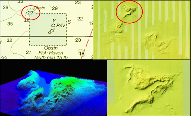
Sonar images reveal a feature that has the appearance of a ragged mountain peak, although bathymetry contours and sounding data indicate the vertical rise is about four to five feet. A color shaded relief image is available using the Bathymetric Data Viewer (BDV) on the National Oceanic and Atmospheric Administration (NOAA) website. The image shows a broad area of naturally rugged bottom, about half of which is inside the fish haven which also holds many artificial structures (see “Chesapeake Bay Fishing Reefs”). The main natural feature has a narrow ridgeline oriented northeast-southwest. The highpoint is about 200 yards long using the BDV image scale, and then extends southwestward another 300 yards or so. The northern mass is about 100 yards long by 50 yards wide. Southeast of the main feature is another natural formation that is about 100 yards long and 50 yards wide. For anyone fishing in this general area, this natural “sea mound” is a go-to spot. Plus, there is the added attraction of broad-area artificial patch-reefs in the fish haven.
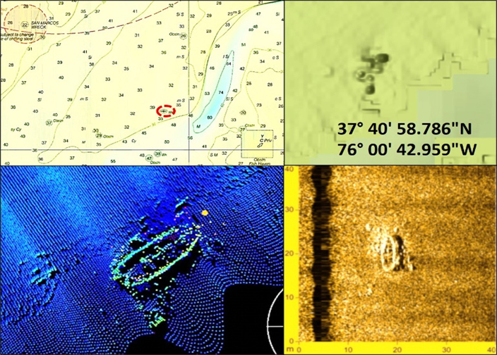
After a short run of 2.3 NM to the northwest, look for a small wreck (Chart 3). It is also about 4.5 NM southeast of the San Marcos wreckage. Although the wreck looks nondescript in the image, it shows the gunnels of a small vessel with scattered small debris around it. Although small, the feature may attract croakers, spot, flounder, and perhaps other sportfish.
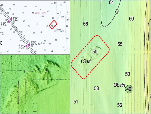
Just below the south end of the southernmost of the two deep-water natural trenches leading into Pocomoke Sound is an uncharted feature that is shown in the BDV image for this area (Chart 4). The anomaly also shows up clearly when using the Navionics Boating HD sonar chart with the color relief overlay. The feature presents as a low-profile natural reef with a vertical rise of about fur feet. Oriented southwest-northeast, it is about 700 yards long and up to about 175 yards wide. The bottom configuration looks well-suited for drift fishing, jigging, and trolling. Situated as it is at the entrance to a deep-water trench, it ought to be a fish magnet.
The natural reefs and deep-water remnants of the ancient Susquehanna riverbed are the dominant structural features in this portion of the Bay. The wrecks and obstructions are small in comparison. The natural features are easier to find and hold over than the much smaller wrecks and obstructions. A good fishing strategy would be to focus the hunt for sportfish on the natural features, and check the artificial structures as opportunity permits.
- By Wayne Young. As well as being a regular contributor to FishTalk, Wayne Young is the author of multiple books detailing wrecks and fishing reefs in the Chesapeake Bay, Delaware Bay, and beyond. All are available at Amazon.com, and you can find his Facebook page at Chesapeake Bay Fishing Reefs.