Sentinel of the Coast: The Log of a Lighthouse Engineer, is an engaging first-hand account of coastal surveys and over two decades of Lighthouse Service history. The author, George Putnam, was the first Commissioner of Lighthouses during the Taft Administration. The Coast Guard’s Aid to Navigation program has changed a lot since Putnam’s classic work was published in 1917, but buoys and channel markers – old technologies – still remain important. Lighthouses and light structures also continue to warn mariners of dangerous waters, but manned lighthouses in the Chesapeake are relics of the past. Some were removed; some were replaced with fixed light structures or buoys; some were automated; some were sold for private use (with Coast Guard access to maintain the light); and some were washed away. A number of Chesapeake Bay lighthouses are today submerged under murky waters, which brings us to our point: thought they’ve gone from navigational aids to navigation hazards, these remains of yesteryear’s lighthouses are today’s fishing hotspots.
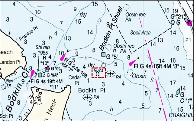
At the outer southern approach to the Patapsco River and Baltimore lay the remains of Bodkin Point Lighthouse, the first lighthouse built in Maryland. It was constructed in 1821 and taken out of service in 1856. Erosion eventually undermined the structure and the Bay took the light. Remains of this sentinel have since taken their share of props and lower units from unwary boaters – as well as adding to the weight of many anglers’ fishboxes.
At one time a neck of land extended northeastward from the current point to well past where the ruins are charted. The extended point became a small island, and then disappeared under the relentless attack of Mother Nature. The light, a classic cone-shaped stone and masonry structure, was alongside a single-story stone and masonry lightkeeper’s house. Historic pictures show an unprotected shoreline. Thus, the bottom is fouled by a lot of shaped stone. Today, the ruins are charted as part of the foul water shoal that extends towards the northeast, providing good structure for light tackle casting. (If you missed it last month, details on fishing at this spot can be found in “Bodkin Point to Belvedere Shoals”).
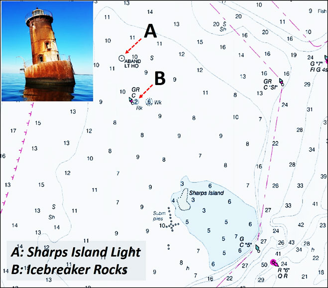
Sharps Island Light, another well-known lighthouse ruins and fishing destination, is actually the third light marking shoals west of the now submerged island. The first light was a movable structure located on the island. Relocated as the island eroded, it was eventually replaced by a screwpile structure in 1866. Heavy ice during the replacement lighthouse’s first winter of service severely pressured the underwater body, so an icebreaker structure was constructed to break up ice before it reached the structure. On casual observation, one might think that the icebreaker would have been north of the lighthouse to protect it from ice moving down the Bay. However, it was located about 200 feet to the south and aligned with the predominant current flow. Heavy winter ice extended farther south back then, down past Smith island. Thus, this positioning protected the light from ice flows being driven up from the south by strong winds and high waves.
The icebreaker consisted of three eight-inch diameter screwpiles. They were buttressed with a couple hundred yards of riprap rock. The second light lasted until 1881 when heavy winter ice broke it free. It floated about 5 miles before grounding. Although that light is long gone, the icebreaker rocks are still there. They are lurking below the surface just north of the charted icebreaker buoy and south of the visible remaining lighthouse. Perhaps remnants of the screwpiles are there also. The rocks are worth a serious poke when searching the flats and often hold fish, but be careful when approaching – this is yet another dangerous obstruction.
A steel concrete filled caisson was selected for the third and current lighthouse. This “sparkplug” lighthouse was built in 1882 and is still in its original constructed location. Heavy ice pressure pushed the tower off-center in 1977. However, it continued in service until 2010 (the modern automated light that replaced the original lens was mounted on a leveling device). An underwater video by Harbor Diving Service and Worm Sportfishing Charters in 2016 revealed a sand bottom surrounding the base. An iron ladder that was on the west side lies crumpled on the bottom, a real hook-snagger, heavily fouled with marine growth. The caisson underwater body appears more lightly fouled. Nevertheless, stripers sometimes are found around the structure, so it's worth some casts after you’ve probed the underwater ice breaker ruins.
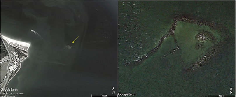
Also among lost lighthouses of the Chesapeake is one that marked Cedar Point. The lighthouse ruins there are well-known to light tackle anglers. Cedar Point Lighthouse wasn't just named after the point, but was on a neck of land that extended from the current point to the northeast end of the ruins. A small pond separated the neck’s northern and southern shorelines. Riprap was placed around the outer end of the point where the light stood. The beacon was housed on the roof of two-story square brick building. Eventually, the neck breeched. A pier was built immediately southwest of the light inside the riprap, which served as a breakwater. It appears that a bulkhead may have been constructed behind portions of the riprap. Eventually, the light was destroyed by Mother Nature. It was replaced by a fixed light on a foundation where the lighthouse once stood. As the remaining land eroded, the riprap displaced and the pier decking was carried away. What’s left is the riprap, most of which is submerged, and broken off pilings, all of which is often productive artificial structure.
Approach the Cedar Point ruins carefully. Pay attention to the current and wind to avoid being swept into dangerous water. When conditions on the west, north, and east sides are unfavorable, it's sometimes possible for a boat to carefully sneak within casting distance from the southwest with local knowledge.
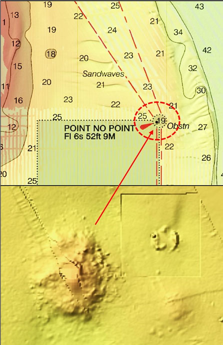
Point No Point Lighthouse is another concrete-filled caisson structure, and one that is still active today. Although the current light is the original structure, mishaps during construction resulted in loss of construction material, equipment, and tools – de facto artificial reef materials. The underwater body consisted of a wooden caisson with steel plates around its upper third or so. During construction, the caisson was floated into position. Sediment was removed by pneumatic means and manual excavation working from within the caisson. (As sediment is removed around the edges and concrete is progressively added during construction, the caisson settles lower and lower into the bottom until the desired elevation of the structure is achieved; voids are filled with concrete to create a heavy solid foundation, while some space is left unfilled to create storage areas for supplies and water cisterns). During construction, the caisson broke free several times before it was entrenched in the bottom – once it floated all the way down to the mouth of the Rappahannock River. Some of the steel plates that were lost could be on the bottom and the NOAA Bathymetric viewer shows structure surrounding the light in a mound formation, making it worth a cast or two when passing through the area.
Another lost beacon was located off the Eastern Shore’s Janes Island. Originally, the shoal that juts out into Tangier Sound was marked by a lightship. The first lighthouse was a screwpile structure. Constructed just after the Civil War in 1866/7, it was taken out by ice in 1879. The light was replaced with another screwpile structure which was also damaged by ice in 1893. The lightkeepers house was carried off into the sound during the winter of 1935/6 (the keeper escaped by walking across the ice to Smith Island). The house floated for several days before sinking. The replacement unmanned light is a caisson structure. The current beacon offers minimal structure for fishing, but may be worth a toss or two in case something is hanging around. More importantly, the ragged shoal the light marks is always worth a look.
An honorable mention also goes to Solomons Lump Lighthouse, marking Kedges Strait. A screwpile lighthouse constructed there in 1875 was severely damaged and knocked out of service by moving ice in early 1893. Spare parts from the wreckage were used to repair ice damage to the aforementioned Janes Island Lighthouse. The current light is an unmanned caisson structure. As with other lights with this type of underwater body, if passing close by, it may also be worth a cast or two just in case a predator is in the area
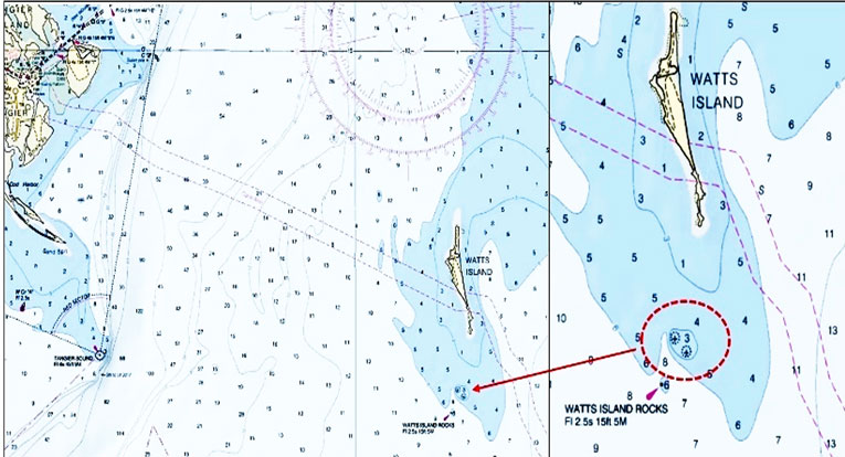
When running east of Tangier Island, try tossing at what's left of Watts Island Lighthouse, known today as Watts Island Rocks. The light, established in 1833, was a classic cone masonry (brick) structure with a frame lighthouse keepers house alongside. It was actually located on Little Watts Island immediately south of Watts Island. Little Watts is now totally submerged. The light was deactivated in 1923 and the island, including the light structure and keepers house, was sold to a private party. Thereafter, it became a hermit’s domain when a city lawyer took on a bet that he couldn’t survive 10 years alone on Watts Island. He later moved into the deserted lightkeepers house on Little Watts, living there most of the time until the late 1930s when he passed over the bar. The light and keepers house were overcome by the Bay during a winter storm in 1944. From the few pictures that are available, the island was similar in character to Watts Island. Essentially it was a sediment bank, so the rocks are probably remains of the lighthouse and possibly riprap if any was used for shore protection. When in the area, also take note of the substantial natural structure that lies to the east and south along the edges of the ancient deep-water channel leading into Pocomoke Sound, and also Anglers Reef Fish Haven which is two and a half miles south of the light marking the Watts Island Rocks.
-By Wayne Young
Author Wayne Young is a former manager of the Maryland artificial reef program for Bay waters and the author of “Bridges Under Troubled Waters: Upper Chesapeake and Tidal Potomac Fishing Reefs." You can also visit his Facebook page, Chesapeake Bay Fishing Reefs.
Sign up here to get the weekly FishTalk Chesapeake Bay and Mid-Atlantic fishing reports in your email inbox, every Friday by noon.