A common theme from commercial fishermen during the research phase of a 1990s national study of fishing vessel safety was, “We don’t go far offshore, so we don’t need new safety requirements.” Wrong! Search and rescue data provided by the Coast Guard for the National Research Council’s 1991 fishing vessel safety report painted a different picture. A computer-generated graphic of the data on a chart showed where fishing vessels had been lost. There were clusters of sunken fishing vessels close to shore just off inlets on all coasts. No real surprise there. Inlets are dangerous places that give no mercy. However, one huge cluster of sinkings off Gloucester, Massachusetts, jumped off the chart — 145 sunken vessels in the same grid. I asked the database keeper what that was all about. The answer: deep water close to shore, where many vessels were said to have been scuttled for insurance.
Is the Chesapeake Bay free of such untoward behavior? Is scuttling a thing of the past? Deliberate attempts to get rid of vessels still happens. During the summer of 2020 a sailboat in poor condition was observed under tow on the lower Potomac off Lewisetta, VA. Later, the same sailboat was found abandoned, dragging anchor, listing, unlighted, and posing a danger to navigation, stimulating considerable discussion on social media. An unofficial artificial reef contender without corrective action.
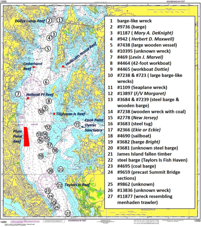
Most Bay wrecks, however, resulted from marine casualties. Maryland’s Middle Bay has its share. Some are routinely targeted by light tackle fishermen. Many are sunken barges, whether from casualties or those deliberately sunk as artificial reefs at state fish havens. Barge wrecks provide large structure and are also often easier to fish than shipwrecks with superstructure, railings, and other features that snag gear. A sampling of wrecks suitable for fishing is shown on the chart.
Perhaps the best known of the Middle Bay wrecks is the Herbert D. Maxwell. The wreckage is located 3.6 nautical miles south of the Bay Bridge off Brickhouse Bar and about 100 yards west southwest of Buoy WR87. The Maxwell was a 185- by 38-foot four-masted wooded schooner carrying freight. She sank following a collision with a steel steamer in 1912. It’s very deep and low oxygen conditions may have helped preserve the wreck for our viewing pleasure with high-resolution recreational sonar. Nearby lies the wreck of Mary A DeKnight. She was a 150- by 23-foot schooner that capsized with the loss of all hands in 1879. The history of each vessel is presented in Gary Gentile’s “Popular Dive Guide Series: Shipwrecks of the Chesapeake Bay in Maryland Waters” (2013). The chart shows the general location of the Maxwell, DeKnight, and several other wrecks in the vicinity.
Substantial structure can be found at Site #10, where there are two barge-like large anomalies first reported by the Navy in 1958. A 1998 NOS hydrographic survey found the largest was a 172- by 33-foot wreck-like structure just northwest of Buoy R82 at 38’42.11.26 x 76’25.28.22. Northeast of the buoy at Site #9 with a least depth of 37 feet is the wreck of the 40-foot workboat Dottie. A bit further northeast at Site #8 is another workboat. The depth of both boats is suitable for jigging, but holding over them in the open Bay is difficult due to their relatively small size.
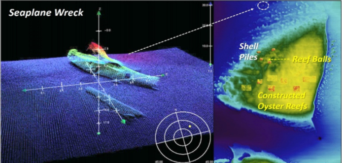
The Choptank seaplane wreck at Site #11 is a well-known fishing hotspot, as is the Cook Point Oyster Sanctuary. The wreck is in several pieces and deteriorated, but still recognizable as an aircraft. From there, proceed south to the Cook Point reef where you’ll find large shell piles, reef balls, and constructed oyster reefs. This area can be extremely productive for numerous species.
Back out in the Main Stem, look for a cluster of wrecks west of Sharp Island flats. Although deep, they may provide seasonal jigging opportunities after the Bay water has turned over late in the year. Site #13 consists of two barges. A 145-foot steel barge sits at 38’37.41.0 x 76’26.02.0 with a reported least depth of 39 feet. Slightly west a 1987 hydrographic survey states the “located remains of large metal structure consisting of large plates and I-beams.”
Site #14 is another deep wreck described in the AWOIS file as a “large wooden hulled vessel carrying large amounts of coal. There are remains of hull ribbing running down both sides with a bulkhead down the centerline. Vessel lying in N-S direction. Keel down. Highest point at stern where long wooden pole protrudes 12 to 15 feet above the rest of the WK.”
The so called “Pitcher Wreck” is the 160- by 23-foot packet freighter New Jersey. It burned and sank during 1870 southwest of Sharps Island at Site #15 in position 38’37.03.2 x 76’24.35.9. The wreck was investigated by NOAA divers during a hydrographic survey in 1987 and has been a recreational dive site. Artifacts including China pottery and glassware have been recovered here. The wreck is in ruins mostly consisting of exposed ribbing. It was a steam screw freighter. Divers found the boiler rises about 10 feet above the bottom.
Site #16 is a 40-foot steel push-boat tug in position 38’26.27.03 x 76.25.50.88. The vessel is upside down on top of a small pilothouse. AWOIS reports that the transom is “partly buried with hull inclined upward from bottom to approx. 50 feet.”
Off the southwest end of Sharps Island flats at Site #17, is the wreck of the barge Ekie. This 149- by 20-foot steel barge sank in 1952 with a cargo listed as nitrate of sodas. It was reported as approximately three miles north of Sharps Island light. However, the position is three nautical miles southwest at 38’35.43.9 x 76’24.43.71. A diver inspection in 1987 found the wreck partially buried towards the bow and resting in an upright position on its starboard side with a 25-degree list. AWOIS records that “It is partially buried in bottom sediments, showed moderate decomposition and heavy encrustation. It’s completely filled with bottom sediments.” Least depth is 46 feet. Although low in profile, the structure is large enough to find inside the wreck circle with recreational sonars. Drift through and jig when the fishfinder is marking bait and predators.
The barge Bright sank in 1940 and is at Site #19. AWOIS reports that a 1987 hydrographic survey found the following: “Wreckage consists of three parts of deteriorated wooded barge (keel beam, ribs, hull planking, two large wooden bulkheads, and metal and wooden spikes). Size of largest section of wreck located at center contact is 114- by 19-feet.” Least depths range from about 52 feet to 57 feet. Check it out as another fall jigging spot.
A wreck sometimes referred to as the James Island barge is at Site #20 in position 38’30.706 x 76’23.507. The U.S. Army Corps of Engineers reported this wreck as an unknown obstruction in 1966. A 1987 hydrographic survey determined that it was a 125- by 22-foot steel barge. The wreck at that time rose 20 feet off the bottom of a seven-foot-deep scour hole. Charted least depth is 44 feet.
Although not a wreck, the area around the remnants of James Island at Site #21 certainly has lots of wreckage-like structure and often holds stripers and speckled trout. Fallen timber around the remnants is mostly submerged, but some huge snags break the surface and these waters provide great marine habitat. Be very careful if venturing there and go no faster than you’re willing to hit a log.
The upside-down barge at Site #22 in the Taylors Island Fish Haven was deployed in 2003 as a fishing reef during my watch as manager of the Maryland Artificial Reef Program for Bay waters. More recently, Maryland’s DNR arranged for the deposit of a load of concrete rubble on and around the barge, which now lies in a scour hole.
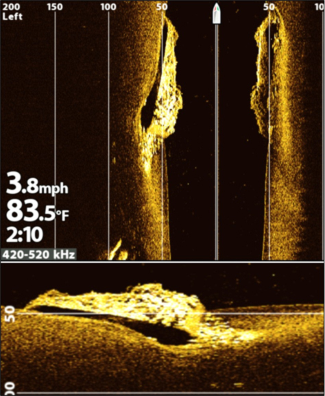
The above image is a side-scan from my Humminbird MEGA sonar. The bottom image was rotated to facilitate interpretation of the image. The barge lies slanted downward into a scour hole and the rubble distributed across the barge bottom is visible. See “Bridges Under Troubled Waters” (Young, 2018) for the fish haven layout.
Across the Bay northeast and east of the Cove Point Gas Docks are a series of wrecks and obstructions at Sites #23 to 26. The latter three are covered by “BAG” Color Shaded Relief imaging. Site #24 is a coal barge that sank in 1978. The wreck was considered a hazard to navigation and AWOIS records that Coast Guard District Five issued a contract for underwater demolition. Part of the cargo and deck timbers were removed. Additional demolition was accomplished by underwater burning. Material was removed and deposited on either side of the wreckage in scoured out trenches.
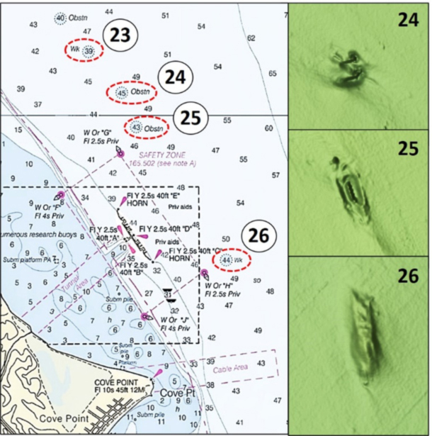
Site #25 consists of one or more bridge sections that were lost overboard from a barge during 1996. Most were removed and transported for deployment as artificial reefs in the Point No Point Fish Haven. They never made it there, ending up at a different location. See “Southern Maryland Mystery Reefs in Chesapeake Bay Fishing Reefs” (Young, 2020).
The last wreck in this writeup, at Site #27, is a sunken fishing vessel. It was an uncharted deep wreck that was found between 2001 and 2004 during a NOAA hydrographic survey using a side-scan sonar. The vessel appears to be a sunken 150- by 31-foot menhaden trawler.
There are certainly other wrecks and obstructions between the Bay Bridge and Cove Point. How many were scuttled, and how many were accidentally lost? We will never know. But when you add them in with the Middle Bay artificial reefs, natural structure, shoreline ruins, and discharge pipes, there’s a lot of structure for light-tackle fishing enthusiasts to prospect.
See our Chesapeake Bay Fishing Reefs Guide to get the lowdown on other mad-made wreck and reef hotspots in the Bay, plus a few in the ocean off the DelMarVa coast.
-By Wayne Young, the author of “Bridges Under Troubled Waters: Upper Chesapeake and Tidal Potomac Fishing Reefs,” “Chesapeake Bay Fishing Reefs, Voyage of Discovery,” “Phantoms of the Lower Bay,” and “Hook, Line, and Slinker.” All are available at Amazon.com, and you can find his Facebook page at Chesapeake Bay Fishing Reefs.
Sign up here to get the weekly FishTalk Chesapeake Bay and Mid-Atlantic fishing reports in your email inbox, every Friday by noon.