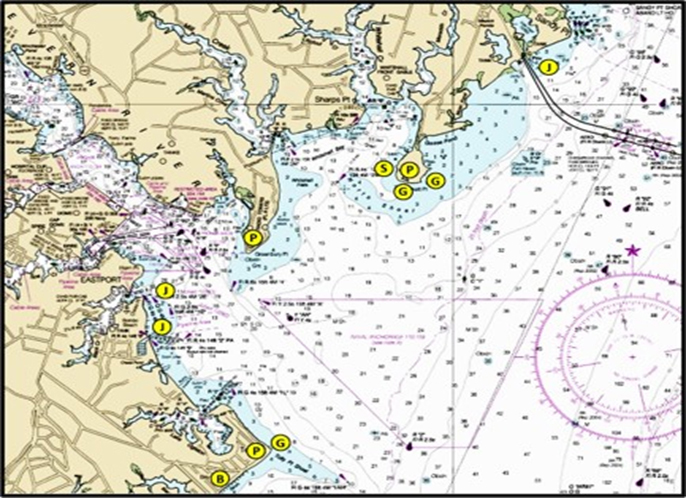
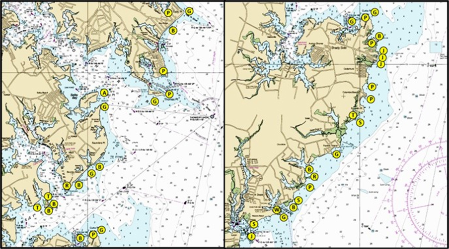
Light-tackle, run-and-gun fans of the Chesapeake are known for targeting Eastern Shore shoreline structure, especially when targeting striped bass. I'll go over there on guide trips, but having downsized to an easy-to-launch skiff, Western Shore structures near the boat ramp de jour have become higher on my prospecting list. Is there structure on the west side similar to that found on the east side, you ask? Absolutely. And, the armchair scouting technique presented in “Chesapeake Bay Fishing Reefs: Voyages of Rediscovery” is how I find them. For illustration and discussion purposes, structure in the below charts is labeled as follows:
- A – Unidentified anomalies.
- B – Segmented breakwaters.
- G – Awash and submerged or partially submerged rock groins.
- J – Rock jetties at entrances to boat basins.
- P – Natural and armored points that jut out and interact with current.
- R – Rock-armored and natural points that have been weathered or submerged such as by scouring, settling on bottoms that lacked sufficient strength for their weight, relative sea-level rise, erosion, or a combination of all of the above.
- S – Stone shoreline protection that failed for similar reasons.
- T – Unprotected and no longer protected shorelines with extensive fallen timber.
- W – Wooden bulkhead and pier ruins.
My search list includes natural structure, rock-hardened points, old rock groins that have settled below the surface, and newer groins that jut out into current flow. Also on my list is rock shore protection that failed and submerged, sometimes with shoreline erosion that puts the remains offshore, segmented breakwater ends and openings, and duck blind pilings. Add these to oyster reefs and fish havens in the tributaries and along the west side at various locations, ruins, and well-known features such as the Thomas Point rocks.
Points themselves are a primary striper prospecting stop because of their interaction with currents. Some points have suspended sediment streams when current is running due to shoreline and bottom conditions, such as at Thomas Point. The best fishing here is often off the point at the shoal edge where there are scattered rocks, and at the lighthouse icebreakers. See Thomas Point Rocks for a full accounting of how and where to fish the shoal.
A number of spots where stone shoreline protection failed have been improved through construction of rock armor to modern coastal engineering standards. Sometimes the new structures are behind the old structures, which were then abandoned in place. These earlier failed or failing structures have, in effect, become artificial fishing reefs. Features like this are worth a few casts when in the area, though the likelihood of finding them is small unless they’re ferreted out in advance through research.
Take special note that some of the failed shore protection structures extend or have outer remnants that are well offshore, or shorelines have receded leaving fallen timber father out than might be expected. Just south of Franklin Point, look for the failed end of stone shoreline armor that has an outer end that's over 100 yards offshore. On the north side is a field of submerged fallen timber. The waters here are shallow. However, the outer end of the rocks can be approached and cast to.
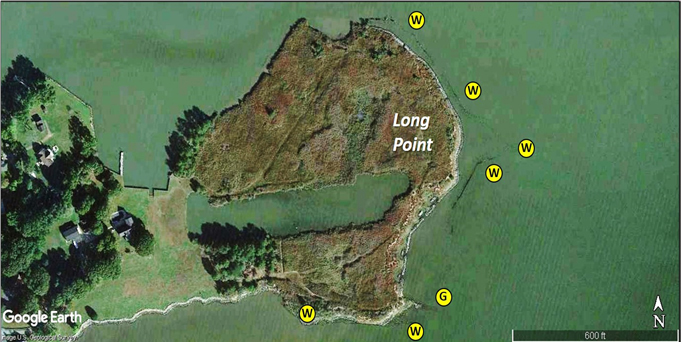
There are also a few areas where there are pilings, some broken off, from long gone bulkheads and piers. Then there are the unlighted and uncharted pound nets. One particularly extensive area of bulkhead ruins is found at Long Point (Image 1) at the mouth of Parker Creek. A wooden bulkhead formerly protected the bayside shoreline. The outer line of pilings marks where the island edge was before the bulkhead failed. Much of the existing shoreline has been re-armored with rock. An old, drowned groin at the southeast corner is just the type of feature I’m looking for to cast to when current is running. It can be approached carefully from the southeast.
We’ll close with a mystery structure south of Turkey Point where Ramsay Lake meets the South River. Marked as an anomaly on Image 2, look for a 125-foot linear structure. The southwestern line of material has the appearance of concrete or possibly large cut rocks. There are a couple of tree snags west of the northwest end. Water here is shallow. It’s been there a long time and was obviously deliberately constructed — when and by whom remains unknowns.
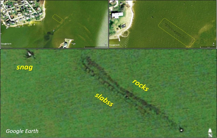
Digging into historic nautical charts confirms that Ramsay Lake was once closed off. Originally charted under that name, it then appeared as Ramsey’s Gut for a number of years, indicating a tidal connection. There was indeed an opening between Little Island and the southwest tip of Turkey Point Island from before the Civil War that is now filled in. The current mouth breached between the late 1950s and 1962. The anomaly is along the outside of where there was a spit after the breach. We think this was shore protection in the form of a slab revetment with a rock toe that ultimately failed. Regardless of derivation, it attracts fish. Editor’s note: Since this is right in my backyard and I hit it on a regular basis: The water here is only a couple of feet at high tide, and during high water it can be an excellent white perch spot. High water at daybreak or dusk can produce rockfish on topwater too, and although the vast majority are in the 12- to 18-inch range I’ve seen fish up to 24-inches come out of here. On low water it’s usually barren and so shallow that even my 16’ skiff will run aground. - LR.
So, that’s a quick synopsis of the west side story, at least the advance scouting part. The fishing part of the story is written each time we go out and prospect such features. Many are passed by as boats head out to wherever the fleet is or where yesterday’s fishing report put the fish. But, if you’re adventurous, like to explore, and are looking for a less pressured day on the water, some of the obscure west side sites might be your ticket.
- By Wayne Young. As well as being a regular contributor to FishTalk, Wayne Young is the author of multiple books detailing wrecks and fishing reefs in the Chesapeake Bay, Delaware Bay, and beyond. All are available at Amazon.com, and you can find his Facebook page at Chesapeake Bay Fishing Reefs.