John Duffy, the late great mandolin player with Washington’s bluegrass group Seldom Scene, once famously said he thought “Roe versus Wade” were alternate ways to cross the Potomac. The primary way to make a Potomac River crossing is, of course, by one of the many bridges going over it. Among them is the 14th Street Bridge complex consisting of three highway bridges (Chart 1). Immediately downstream are a railroad bridge and a Metrorail bridge. The railroad bridge is slated for replacement. Within the complex are many bridge piers to target as fishing structure, especially the stone railroad bridge piers with wooden cribbing. Current roars through the openings on the ebb tide. As a former three-time commuter to Coast Guard Headquarters when it was located at Buzzards Point in southwest DC, the highway bridge holds many memories for me—and of course I used to think about fishing those piers while creeping over the bridge during traffic jams.
Fishing Structure at 14th Street Bridge Complex
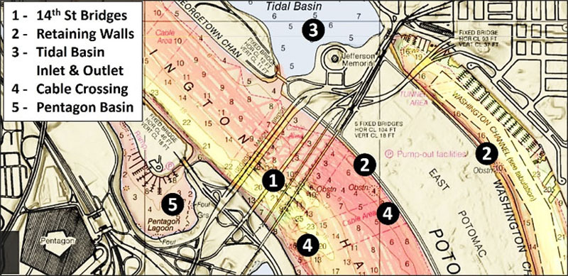
Chart 1 shows the general location of primary features on both sides of East Potomac Park, which separates the river from Washington Channel. The park is reclaimed land constructed using dredged material from river clearing and deepening projects. There are a lot of structural fishing options around the 14th Street Bridge Complex (Site 1). The stone retaining walls marked in general as Site 2 provide fishing opportunities for catfish, bass, and stripers along their length. Site 3 is the tidal basin, which holds a lot of fish, some quite large, providing shore fishing opportunities. (See Delighted in DC for some details on fishing here.)
What we see around bridge piers are extensive scours trailing off downriver. With a large inflow of freshwater into the upper tidal Potomac, strong ebbs are produced during falling tidal action. The net discharge under the bridge is downstream. The denser saltwater wedge that works its way up from the Chesapeake Bay entrance is way downstream, so strong counterflows upstream along the bottom aren’t present here as they are in the lower Potomac. Current carries baitfish to the piers; check the leading edges and the sides. If they’re not producing, check the down-current ends.
Site 4 is a cable crossing, which creates structure but is a do-not-anchor zone. Site 5 is the Pentagon Lagoon, a well-known bass fishing hotspot. This sheltered lagoon provides a destination when conditions on the main river are unfavorable. The Boundary Channel immediately north of the last dock in the Columbia Island Marina, a National Park Service facility, is very shallow and falls bare during blowout conditions. This is kayak water at best when water levels are up.
Memorial Bridge Fishing Structure
Arlington Memorial Bridge (Site 6), the next bridge to the north, is covered by the “BAG” Color Shaded Relief data layer. Huge scour holes are evident around the pier bases. Scour would be expected around the base of the piers on the western side of the bridge as well. The east side pier appears to border sediment rather than a hard bottom, although the image is inconclusive. Try dropping bait into the drop-off at the upriver end of the bridge piers as well as down along the sides.
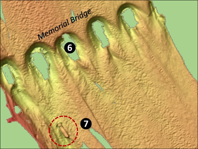
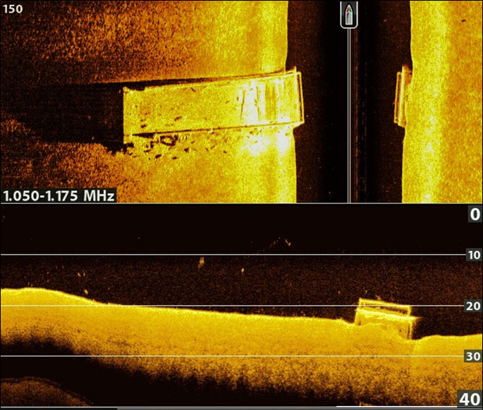
Inside the dashed-line oval (Site 7) was recorded as a “new wreck” during a 2012 hydrographic survey at coordinates 38'53.1516 x 77'03.3133. Imagery shows a rectangular shape that presents as a barge or perhaps a canal boat in a scour hole. The estimated dimensions using the embedded BDV distance scale are 100’ long and 15’ to 20’ wide, which suggests a canal boat. Although recorded as a “new” wreck, it’s anything but new, but how long it has been there is unknown. The wreck provided a good target for my Humminbird Helix 10” MEGA+ fishfinder while catfish fishing during August of 2023. The top screenshot is a side-scan sonar image and by appearance, the wreck is a flat-deck wooden vessel. It measures about 130’ long and 15’ to 20’ wide. There is a railing around the ends and sides as one of my catfish rigs will attest. The bottom screenshot is a down-looking scan which shows the wreck resting on a gradual slope. Dark shadows at one end, where there appears to be a hole in the hull, mark some catfish.
If hard structure isn’t producing, try drifting the channel edges or anchoring at the up-current end of holes and dropping circle hooks on fishfinders tipped with your favorite catfish bait. The boat ramps available for this section of the river are the public ramp at Gravelly Point and at Columbia Island Marina. A kayak can be launched at the parking lot for Roosevelt Island. Note that these are District of Columbia waters and a DC fishing license is required.
-By Wayne Young
As well as being a regular contributor to FishTalk, Wayne Young is the author of multiple books detailing wrecks and fishing reefs in the Chesapeake Bay, Delaware Bay, and beyond. All are available at Amazon.com, and you can find his Facebook page at “Chesapeake Bay Fishing Reefs.”