Unless you're talking about a fishing destination or “rocks” as in rockfish when you start trolling for spring stripers in a few months, you generally don't want to hear "rocks ahead" when you're running a boat. Speaking of rocks, both sides of Point Lookout abound with rocks, oyster rock, and sometimes rockfish, too. Rocky bottom west of the point at the southern end of Cornfield Harbor is charted and well known (location “A”). A spot known as Jobs Rock historically has been good flounder ground although the chance of catching keepers increases down the Bay. Who knows where the place name came from — the origin seems lost to history. Look for stripers on the west side during spring and fall. The short run from the Point Lookout State Park boat ramp is a definite plus, as is the shelter provided from northeasterly winds. Westerlies are another matter, however. The ramp is well inside the harbor and open all year. There’s also a nice covered fish-cleaning station, but I’ve found it locked down during the off season.
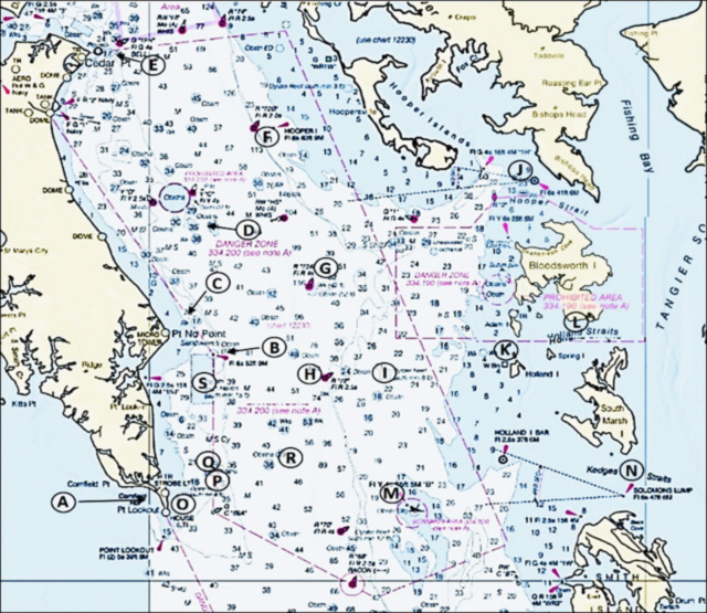
The east side of the point also offers fine fishing grounds. What appears as mounds on a nautical chart is instead hard, rugged, irregular bottom that suggests rock formations. The presence of numerous anomalies not worn flat by oyster dredges again suggests some rock is present rather than oyster rock composed entirely of shell. My go-to put in for these natural reefs and other spots north and east of Point Lookout and eastern side spots across the main stem is Buzz's Marina, located on the southern prong of St. Jerome Creek. The very narrow hairpin turn from the southern prong around the inlet sand spit is a bit exciting. Yet, the inlet is very well positioned for making a circuit to the north, east, and southeast — so let’s go running and gunning.
Say Bye From Buzz’s Marina
Just outside the inlet is the Point No Point fish haven. A huge quantity of artificial materials provides habitat and fishing opportunities, discussed later (see also “Bridges Under Troubled Waters”). Point No Point Lighthouse is at the northeastern corner of the fish haven (location “B”). It’s a caisson “fireplug” style light structure. The underwater structure is fouled by marine organisms. It and the mound around it are certainly worth a few casts. Trolling around the lighthouse and through the fish haven for stripers and Spanish mackerel can produce when fish are present but scattered. Immediately east of the lighthouse are some debris. The Coast Survey’s Automated Wreck and Obstruction Information System (AWOIS) reports that this material is possibly the remains of an old lighthouse. Metal sheathing was lost during construction of the light several times due to storm conditions. So, the somewhat circular bottom anomaly could be this material.
Charted rocks lie 1.5 nautical miles 334 degrees true from the lighthouse (location “C”). Rather than a single rock, the National Oceanic and Atmospheric Administration (NOAA) Bathymetric Data Viewer (BDV) side-scan sonar image shows a highly irregular outcropping. Sounding data indicate vertical height in the range of five to eight feet. The structure visibly resembles other bottom formations from there south to Point Lookout, suggesting the presence of rock even though it’s not charted as such. The BDV also shows a broad, irregular, rugged ledge that more or less follows the shoreline that extends northwest for about four miles. Sounding data indicate drop-offs on the order of five to six feet across the ledge.
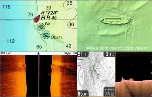
Five nautical miles due north of the light “Summit Bridge" artificial reef (location “D”) is hidden under an obstruction circle. Five miles further north (location “E”) are the Cedar Point Lighthouse ruins and displaced riprap shore protection. Running southeast from there about 6.5 miles is Hoopers Island Light (location “F”), another “sparkplug” style caisson lighthouse. Six miles east southeast of the lighthouse, or running east across from St. Jerome inlet, is Buoy 72A (location “G”). A wreck is nearby near the edge of the shelf on which it sits. The wreck is about 225 feet long. From the NOAA BDV side-scan sonar image and my down-looking sonar scan, what remains are the vessel’s sides and a keel or keelson. AWOIS wreck data records the wreckage, but is unrevealing about its history. The structure rises a few feet off the bottom, although from the down-looking scan, portions of the sides, perhaps remains of bulwarks, rise up a few feet more. The bottom is relatively flat where the wreckage lies. Depths were between about 45 and 54 feet, so it’s deep. But, it’s a spot to try jigging when oxygen levels improve at depth and the fishfinder is showing feeding activity down there.
About 3.5 miles to the south of 72A is Buoy 72 (location “H”). A prominent mound projects westward from the channel edge into the deep channel. This underwater feature obstructs free current flow and probably creates upwelling and subsurface turbulence we can’t see, contributing to favorable foraging conditions for predators. So, the bottom bathymetry makes areas around both buoys trolling and jigging destinations. Try for stripers, redfish, and Spanish mackerel. The occasional cobia is also encountered in season when a surgical tube is in the trolling spread.
The Dorchester Power Dredge Oyster Sanctuary (location “I”) is two miles east of the buoy. Twenty-five “Bay Balls” (modestly sized Reef Balls) were placed there as a field trial to assess the potential for natural spat sets. Redfish have been caught there. Nine miles to the north northeast of the sanctuary (location “J”) is Hooper Straight Light. A submerged rockpile on the north side is always worth a cast or two, but it’s a hook-grabber. The screwpile lighthouse, now located at the Chesapeake Bay Maritime Museum in St. Michaels, MD, stood here marking the site. It was removed and replaced by a skeleton steel tower. The first screwpile lighthouse, which replaced a lightship, was carried away by ice. Histories of the light don’t mention a rock pile. Best guess is that rocks were piled underneath the structure to strengthen it for heavy ice years, similar to the rock protection at Thomas Point Lighthouse.
Holland Island ruins (location “K”) are about 4.75 miles to the east northeast of the oyster sanctuary. The extensive submerged obstructions are very hazardous, but sometimes draw stripers. Be very careful going in there (see “Bridges Under Troubled Waters” for a layout drawing and pictures). About 2.25 miles to the northeast of the Holland Island ruins is a charted submerged barge wreck off Cove Point on Bloodsworth Island (location “L”). The wreck is broken into three pieces, and the bottom it covers is larger than the wreck symbol. Be careful when exploring the area as there are dangerous obstructions on the west side of the island including submerged Army tanks that must be avoided. Not too long ago, a boat with a load of students out on an environmental education trip hit one and sank. They were all rescued off the cabin.
Heading Back West on the Bay
Back at Buoy 72, it's a six-mile troll or run down to the Target Ships (location “M”) and the nearby Middle Grounds, and to the southwest, the Southwest Middle Grounds, another hotspot. The Target Ships are still used by the Navy for live fire training. From the Target Ships, it’s about a 7.75 mile run east to Solomons Lump Light (location “N”). Try casting jigs to the light. Eight miles west northwest of the Target Ships is the fishing ground east of Point Lookout and a host of natural reefs. Spots to check on the east side of the point include:
- Location “O” - St. Mary’s Power Dredge Oyster Sanctuary;
- Location “P” – Hotel Rock;
- Location “Q” – Butler Rock; and
- Location “R” – obstruction that may be vessel wreckage.
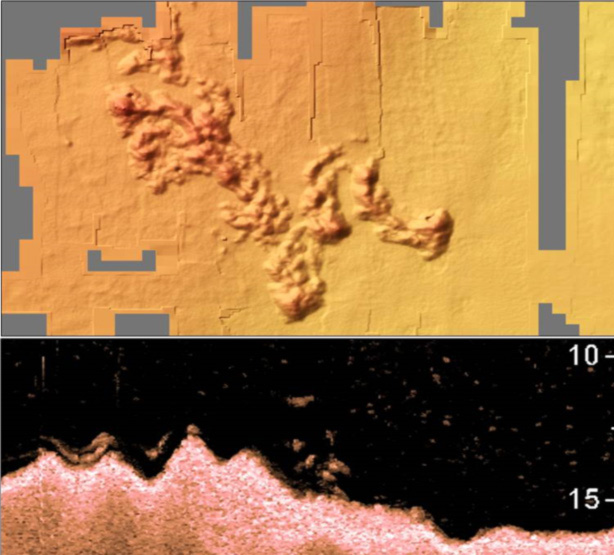
The sanctuary off Point Lookout is one of the original reef ball field trial locations, where 25 bay balls were rapidly colonized. A natural reef at the southeast corner of the sanctuary is the sanctuary’s most impressive structural feature. The bottom configuration shown in the BDV image, my down-looking sonar scan, and the fact that this feature was not worn smooth by oyster dredges, suggest a natural oyster reef with hard rock. There’s as much as five feet of vertical relief. The fish shown in the down-looking sonar scan are likely schoolie striped bass, as we jigged one right after the scan screenshot was recorded in August of 2019.
Two prominent natural reefs are about 2.5 miles northeast of the point. A spot known locally as Hotel Rock (location “P”) forms a narrow ridge oriented north-south which rises as much as six feet above the surrounding bottom. Butlers Rock (location “Q”) is another old place name of uncertain origin that used to show on charts. Union General Benjamin Butler was involved in the Confederate prisoner of war camp at Point Lookout — maybe he fished there? The feature consists of a large mound with multiple high points. It is very rugged, juts up about six feet, then drops off sharply on the southeast side.
East northeast of Point Lookout about 4.5 miles is an obstruction (location “R”) with two very rugged objects. The BDV sides-scan image suggests two scows with spilled cargo.
From the Point Lookout area, it’s a five-mile run north to the center of the Point No Point Fish Haven, and two miles back to the St. Jerome inlet hairpin turn. Look for individual artificial structures in the lower portion of the fish haven. Towards the center (location “S”), look for a massive deposit of bridge rubble between two steel barges and the remains of the Felicia. The sunken vessels have been there a long time, and attract both bait and predators. In between the two barges is a near-continuous large, rugged, and hard-to-fish mass of randomly placed Wilson Bridge demolition materials. Jigging over top the sunken barges is an option, as is fishing the frame of the Felicia. Everything about this vessel has been lost to history but its name. Some of the rubble landed on top of one of the barges, which complicates jigging it. A drop-shot style rig with a sacrificial weight on a tagline below the bait or lure can sometimes help reduce hang-ups.
The run and gun circuit described here is 65 miles, give or take, not including side trips or forays to more eastside island hotspots for stripers and speckled trout. It’s definitely a good day’s fishing workout to run that much — but well worth it to find fish.
Wayne Young is the author of “Bridges Under Troubled Waters: Upper Chesapeake and Tidal Potomac Fishing Reefs,” “Chesapeake Bay Fishing Reefs, Voyage of Discovery,” “Phantoms of the Lower Bay,” and "Hook, Line, and Slinker." All are available at Amazon.com, and you can find his Facebook page at Chesapeake Bay Fishing Reefs.
Sign up here to get the weekly FishTalk Chesapeake Bay and Mid-Atlantic fishing reports in your email inbox, every Friday by noon.