During 1969 the USS Manta became the fourth demolished submarine to adorn the Bay’s bottom, when it was blasted into oblivion by the Navy as a bombing target and sunk somewhere in the area we report on as the Way South section of the Chesapeake. The final resting place was reported as coordinates 37°02'20.40" x 76°11'27.60 just south of the Virgina Marine Resources Commission Bluefish Rock Artificial Reef. This spot is partially covered by Bathymetric Attributed Grid (BAG) Color Shaded Relief which is viewable using the NOAA Bathymetric Data Viewer (BDV). Yet no anomalies are displayed by the BAG data layer and nothing is recorded at this spot in the Coast Survey’s Automated Wreck and Obstruction Information System. So, where is Manta?
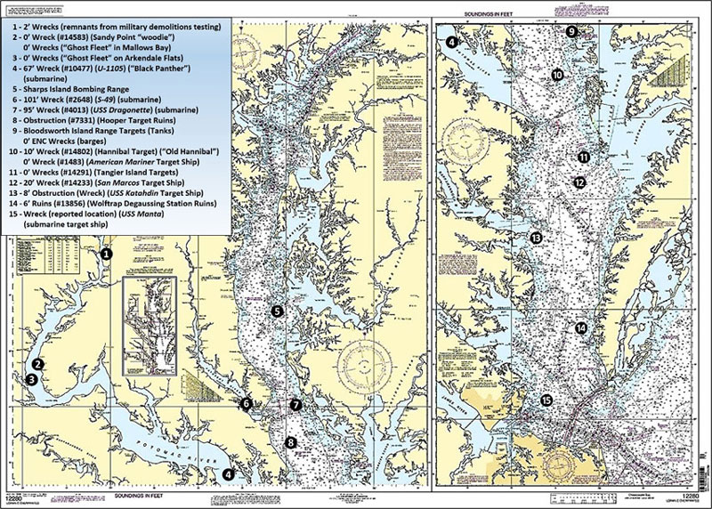
Before armchair scouting for Manta, let’s recap Navy, Army, and Air Force “contributions” of marine structural habitat to the Bay and tributaries in the form of military targets and vessels that were demolished during tests, diver training, and salvage, in the locations shown by Chart 1. These are in addition to past and present military firing and test ranges in the Bay and Potomac River. Fishing hotspots are often located adjacent to, near, or within range boundaries. Some are accessble when not live for military activities and others aren’t. Check charts for warnings and restricted areas and remember that each range area and target ship could have unexploded ordnance in surrounding waters; if you snag an object that looks suspicious don’t bring it aboard.
Site 1 is just south of the Wilson Bridge between the ship channel on the west side and the south end of Rosalie Island. This spot was used for explosives and demolitions training. Uncharted wreckage may be encountered almost anywhere. So, this extensive shoal area should be considered for prospecting throughout.
Wooden ships built to support military logistics during World War One were salvaged at two spots in the Potomac River. The ships were burned to the waterline and work crews then collected metal from the wreckage. The largest mass of these burnt-out “woodies” is in Mallows Bay (Site 2) where there’s a public boat ramp at the end of Wilson Landing Road. The area is littered with hulks, many submerged, which pose hazards to navigation but also provide cover for fish. Half of the old steel vehicle ferry Accomac is adjacent to the creek channel that leads to the boat ramp (the other half is thought to be the steel wreckage further north off Stump Neck). There’s also a woodie grounded on the shoreline just to the north at Sandy Point. The wrecks are best accessed by kayak, although a shallow draft boat with trolling motor can be carefully worked into the site.
The salvage operation was initially at Widewater (Site 3) on Arkendale Flats but was removed to Mallows Bay after local complaints about smoke. There’s a cluster of at least 10 woodies centered at coordinates 37°26.243 x 76°19.159.They’re mostly submerged but two break the surface; one is due west perpendicular to the shoreline and one drifted south and grounded at coordinates 37°26.596 x 76°19.102. Note that there’s a recently constructed public boat ramp at Widewater State Park in Virginia. Launching here provides quick access to the wrecks immediately to the north and the extensive shoals, which are striper grounds, to the southeast. Both of the salvage spots are also bass fishing hotspots. They’re now within the Mallows Bay-Potomac River National Marine Sanctuary. Look for snakeheads in the little bay immediately east of the Mallows Bay ramp.
While attending a craft fair and tasting event at a Fredericksburg distillery a few years ago, I happened to meet retired recreational diver Uwe Lovas. He reprised his underwater searches for shipwrecks in the Bay and along the Atlantic Coast. Uwe and fellow divers rediscovered U-1105, the Black Panther, an experimental stealth U-Boat covered with rubber tiles to absorb sonar pings. The sub now lies northwest of Piney Point at Site 4, unfortunately, too deep for effective sportfishing.
Site 5 marks Sharps Island Flats, the geology of which is examined in my books “Bridges Under Troubled Waters” (2018) and “Chesapeake Bay Fishing Reefs 2” (2023), which also provides an update on nearby wrecks. After Sharps Island eroded away to its last few acres, it was used as a bombing range. Period reports say it was bombed by both the Navy and Air Force. Some of the bottom debris in the shallow area on the eastern side may be remnants of the targets. However, natural rock formations, the lighthouse ruin, and the submerged icebreaker rockpile to its south are the primary fishing destinations.
Another submarine wreck, that of S-49, a pre-World War II submarine, is on the bottom west of Point Patience in the lower Patuxent River at Site 6 in coordinates 37°19.899 x 76°29.266. This sub rises about 11 feet above the bottom in 100 feet of water. Dr. Kent Mountford, writing for the Bay Journal in 2010, described S-49 as about 220’ long and 22’ wide. She foundered and sank while under tow. Divers are said to have encountered strong currents around the wreckage, and they found it festooned with monofilament nets and colonized by a large number of oysters set on the steel hull. The third submarine relic is USS Dragonette, SS-293, Site 7 at coordinates 37°20.494 x 76°18.259. This World War II submarine was sunk in 1961 by a Navy underwater explosion test. Dragonette lies in 135 feet of water off the north end of Barren Island.
The “Hooper Target” is marked as Site 8. This is the circular charted restricted area south of Cedar Point. Former bombing target platforms are now submerged ruins. Site 9 marks the general location of a cluster of tanks in the Bloodsworth Island range. There are other tanks and several sunken barges at coordinates 37°10.170 x 76°05.394 and 37°08.785 x 76°03.141, primary fishing structures. Use caution when fishing here as wreckage comes up to the surface on low tide, but it also holds plenty of fish.
The “Hannibal Target” northwest of Tangier Island at Site 10 consists of the submerged, bombed out remains of the target ship Old Hannibal and the rusted, shot up, breaking apart remains of the target ship American Mariner. The area is a well-known and popular spot for cobia, redfish, stripers, and many other species.
Site 11 marks the Tangier Island range, a restricted area where there was a Liberty Ship target. The 20’ least depth wreck of the Target Ship San Marcos is at Site 12. Site 13 marks a charted eight-foot least-depth obstruction off Stingray Point that is consistent with the dimensions of the lost target ship USS Katahdin. This is a heavily colonized narrow reef about 100 yards long. Down the Eastern Shore inside the “The Cell” fish haven are the ruins of the Wolftrap Degaussing Station (site 14), a massive subsurface structure that consists of foundation materials and cable piles — and plenty of fish.
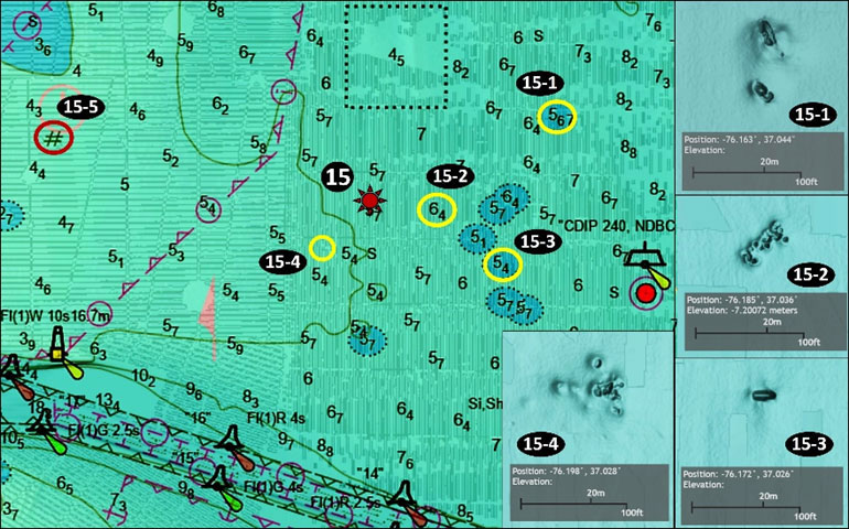
The last stop on this scouting voyage is the supposed location of USS Manta and candidates for its actual location. This Balao Class submarine was about 312’ long, 27’ wide, and had a 16’ draft. Several websites give the Manta’s location (marked by a red multi-pointed star) on Chart 2) as Site 15. On the BAG, however, only flat bottom is displayed at the reported location. Checking the data layer inside of Bluefish Rock Fish Haven, none of the structures there resemble a submarine. Scanning the data layer covering surrounding waters produces five anomalies, some charted and some not, including some that could be what’s left of Manta.
There is a charted obstruction marked as Site 15-1 at coordinates 37°02.635 x 76°09.782, east southeast of the fish haven. There are two 18’ least-depth rectangular objects that each measure about 20’ by 10’. There’s not enough here for a submarine but this does look like a spot worth checking for fish. Site 15-2 marks an uncharted obstruction with a least depth of about 20’ to 22’ at coordinates 37°02.160 x 76°11.154. There’s a cluster of at least a dozen small unidentified objects. The anomaly is about 100’ long and 20’ wide. Although shorter than the sub it could be partially buried, so it’s in the “maybe” category. The feature at Site 15-3 is described as an inverted wreck at coordinates 37°01.546 x 76°10.293. It measures about 35’ long and gives the appearance of an unidentified small boat wreck. An uncharted anomaly consisting of a cluster of distributed objects is marked as Site 15-4 at coordinates 37°01.677 x 76°11.916. The cluster has a least dept of about 16’. It measures about 150’ long and about 100’ across. The length is off but it could be that vessel if it was blown to bits and smaller pieces are covered in sediment.
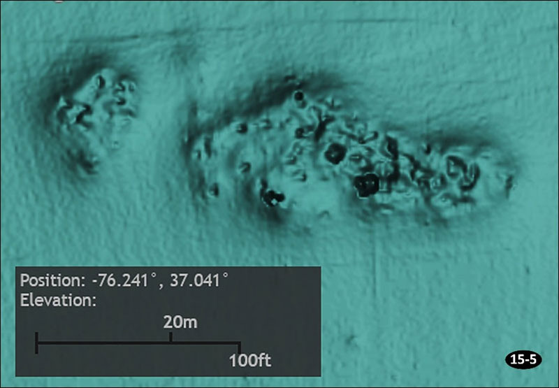
The best candidate for Manta, however, is an unidentified but charted 15’ least-depth wreck marked as Site 15-5 at coordinates 37°02.466 x 76°14.432, recorded as distributed wreckage. BAG Color Shaded Relief shows many small objects in a large, shallow scour, as shown by Image 1. Measurements using the BDV distance scale are about 250’ by 50’ wide. It’s about 2.5 miles west of the sub’s reported location, but on almost the same latitude. Although there’s not enough data to confirm this wreckage as Manta, the distributed remains fit a bombing target scenario. Field work for the survey that developed the BAG data layer was performed in 2016, so the displayed wreckage is probably representative of present conditions. It’s the largest bottom feature in the immediate vicinity and certainly worth a look when heading out for Bluefish Rock or Bluefish Rock Fish Haven.
-By Wayne Young. As well as being a regular contributor to FishTalk, Wayne Young is the author of multiple books detailing wrecks and fishing reefs in the Chesapeake Bay, Delaware Bay, and beyond. All are available at Amazon.com, and you can find his Facebook page at “Chesapeake Bay Fishing Reefs.”