Established in 1970, the Tower Reef is one of Virginia’s early artificial reefs and was originally sponsored by the Tidewater Artificial Reef Association of Virginia (TARAV), before becoming part of the official State reef program administered by the Virginia Marine Resources Commission (VMRC). It’s no problem finding the site. Just steer towards the towering Chesapeake Light because the reef is about a half mile west-southwest of the tower. The first structure placed in the fish haven was an old menhaden trawler. Planned additional reefs for the Tower Reef were tires, landing craft, and other materials. There are actually two reef sites to fish. The other is the massive light tower. There are also a number of charted and uncharted wrecks and obstructions south and southwest of the charted reef boundary.
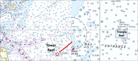
Resources to scout bottom structure at this reef site include the VMRC grid drawing, narrative for the fish haven, and a 2010 side-scan sonar report. Also available are the Navionics Chart Viewer sonar charts and community layer, diver underwater videos, and the BAG Color Shaded Relief image available using the Bathymetric Data Viewer (BDV). Armchair scouting using the aforementioned resources reveals several broad, rough mounds. Although conditions change over time, the depiction seen here is approximately representative of existing conditions. The western half of the fish haven straddles one of the mounds. The eastern half lies on the east side of the mound down into a trench, almost a ravine, between two mounds. This bathymetry would be expected to provide interesting hydrodynamic interactions with current flows, which should favor predator foraging and fishing. The Light Tower is in the middle of the eastern mound.
Chesapeake Light has a massive underwater structure. Diver videos posted on YouTube provide a closeup view of its heavily biofouled tubular structure. There’s a large, dense mussel bed spread out across the bottom beneath and around the tower in addition to some sandy areas. Multiple species of fish are shown in the video on the mussel bed and suspended under the structure. Schools of fish are shown at the corners where multiple tubular supports intersect. Although there are some pipes or tubular support pieces lying on the bottom, there is little else to snag tackle other than the mussel shells and the structure itself. The tower is a good place to start before taking on the spread-out, irregular, rugged artificial structure in the fish haven. Each leg of the tower provides a visual reference that facilitates boat positioning. There’s also an uncharted obstruction or small wreck about 50 yards west-northwest of the northwest corner of the tower.
The wrecks and obstructions southerly of the fish haven are all rather small. However, those in charted wreck and obstruction circles are relatively easy to find by using electronic charts as a reference to steer into the circles. Although relatively minor structures, they may attract fish. They also appear to be smoother and thus more friendly to end tackle than the more rugged and irregular materials within the fish haven.
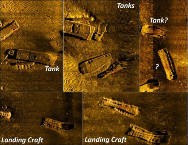
The VMRC grid and the BAG Color Shaded Relief image confirms a patchwork quilt of different materials of opportunity. TARAV, VMRC, and material donors and sponsors collectively placed thousands of tires in concrete, 100-plus pontoon sections, numerous landing craft, barges, a tug, the menhaden trawler, four drydock sections, four barges, tanks, subway cars, and miscellaneous vessels and materials. Some reefs are by themselves, some are alongside each other, and a few are stacked. The BAG montage image also shows that reef materials are in scour holes. This indicates there is considerable current flow and periodic turbulence affecting the bottom, as would be expected off the mouth of the Chesapeake Bay.
Trying to identify specific reef structures at Tower Reef is an exercise in frustration. The water depth at Tower Reef is below the threshold where BDV image clarity is sufficient to distinguish most reef materials by type. Electronically overlaying the grid and a screenshot of the Navionics community layer (which has a number of reef sites marked by users) is not all that helpful either. There was insufficient alignment to enable positive correlation with objects shown in the BDV image. However, images and coordinate data from a VMRC 2010 side-scan sonar report prepared for this fish haven enables locating a few of the reefs.
The tug J. B. Eskridge, sunk in 2002, is the tug at 36’53.95034 x 75’43.34989. An underwater video by diver J. K. Jenkins on YouTube explores the tug and shows her condition as a fishing reef. The wreck is a substantial structure and intact. The 2010 sonar report included excerpts for many of the individual structures, but the preparers were only able to identify a few by type.
Coordinates for more of the structures in the fish haven can be obtained by consulting the sonar report, available at the VMRC website. A more complete set of coordinates for this fish haven correlated with the BDV image, albeit without specific characterization as to structure type, is contained in the Virginia Artificial Reef Guide published for the Virginia Saltwater Fishing Association (VSSA).
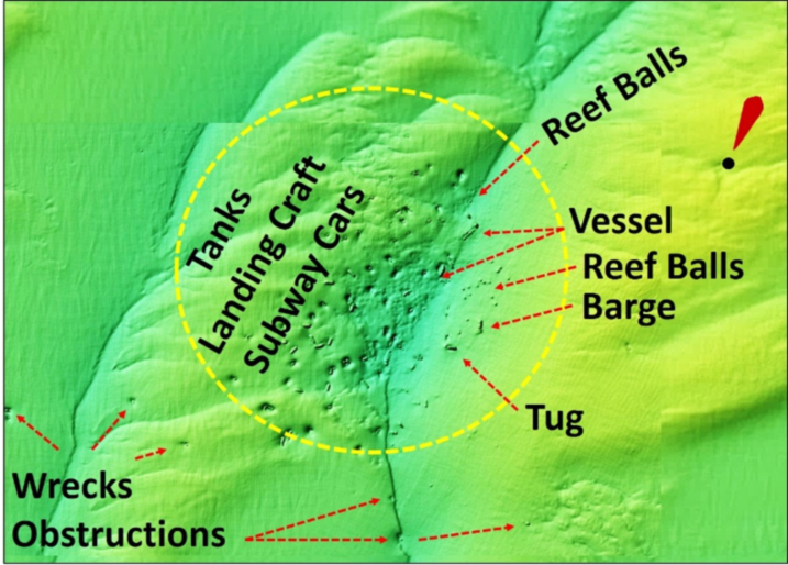
Ultimately, the only reef identifications for which I have high confidence are the tug and the sonar report excerpts which have coordinates for the object in the excerpt. Without local knowledge of the reef’s sweet spots or high-definition sonar scans to help identify structure, a reasonable fishing strategy would be to fish the few larger structures shown by the BDV image first, starting with the tug. The tug and other vessels and some of the tanks and subway cars are marked by icons in the Navionics community layer for those that use this technology. The accuracy is uncertain, but I’ve found that user positions tend to be reasonably close. Whether or not they got the reef type correct is an open question. If these structures don’t produce, run a ladder search pattern across the reef taking fishfinder and sonar scans until something promising shows up. Reef fish relate to structure, and so should those who want to catch them!
If anchoring, there’s a lot of material to snag. Reef spacing makes it difficult to anchor just off individual structures in open water area. Consider rigging a trip line or use an expendable reef anchor or a grapple with bendable prongs, when anchoring here.
See our Chesapeake Bay Fishing Reefs Guide to get the lowdown on other mad-made wreck and reef hotspots in the Bay, plus a few in the ocean off the DelMarVa coast.
Wayne Young is the author of “Bridges Under Troubled Waters: Upper Chesapeake and Tidal Potomac Fishing Reefs,” “Chesapeake Bay Fishing Reefs, Voyage of Discovery,” “Phantoms of the Lower Bay,” and “Hook, Line, and Slinker.” All are available at Amazon.com, and you can find his Facebook page at Chesapeake Bay Fishing Reefs.
Sign up here to get the weekly FishTalk Chesapeake Bay and Mid-Atlantic fishing reports in your email inbox, every Friday by noon.