The popular angling venues Windmill Point Reef and the nearby natural reefs off the mouth of the Rappahannock River were featured in “Chesapeake Bay Fishing Reefs: Voyages of Rediscovery” (Young, 2020), but the reef story doesn’t stop there. Out there off the spit are some interesting “unknown” bottoms and obstructions and several obstructions that sure look like constructed artificial reefs where none are recorded. Out there too is the “lost” target ship Katahdin, an experimental harbor defense ram dating back to 1893 that was sunk by gunfire and abandoned in 1909. There’s also an interesting uncharted anomaly north of the north end of Rappahannock Shoal Channel.
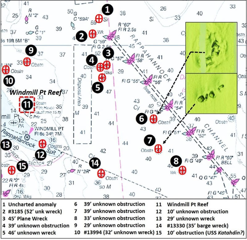
Starting with the latter, Site 1 on Chart 1, using the Bathymetric Data Viewer (BDV), the anomaly appeared to consist of multiple objects with vertical relief. The feature is about 125’ long and 100’ wide. However, it turned out to be an uncharted depression. The deceptive character of the image is attributed to bathymetry shading according to information received from the National Oceanographic and Atmospheric Administration (NOAA) after reporting the anomaly. Ship pilots weren’t aware of anything there either. But logic says something caused the irregular depression; there might be structure in the hole. The surrounding bottom is relatively smooth. So, the feature may attract bait and sportfish and appears large enough to find easily.
Northwest of Buoy G “59” at Site 2 is a 52’ wreck. In 1949 the Steamship Oremar reported striking an object that was later determined to be a wreck. The reported depth was about 34.5’. When the most recent hydrographic survey was performed by a contractor for the National Ocean Survey (NOS) in 2006 the least depth had increased to 52'. The BVD image covering this feature shows rectangularly shaped wreckage about 120’ long and 20’ to 25’ wide oriented southeast-northwest. The image also seems to show the wreckage partially infilled with sediment. There is a deep scour hole on the northeast side. This indicates that currents driven by a combination of flood tides and exposure to strong physical energy from wind-driven waves from the southeast are dominant in this area. The wreckage appears to be listing into the hole. These combined effects are reflected in the increase in least depth as the hull settled into the scour hole. This feature, although relatively deep, offers substantial structure for spring and fall fishing.
Look for a structure cluster west and southwest of Buoy G “57”. Closest to the buoy is a plane wreck (Site 3). Just to the west of the plane is an obstruction (Site 4). Just south of the latter is another wreck (Site 5). The most interesting is the airplane wreck. It is a light aircraft that crashed during a student solo flight. The student was rescued; the plane wasn’t so lucky.
Sites 6 and 7 shown on Chart 1 are by appearance unofficial artificial reefs. Color Shaded Relief images of these reefs are overlaid on Chart 1. Site 6 appears to be bridge sections placed in a semi-circular pattern and mostly covered by sediment. Site 7 appears to be slab and beam forms placed in a line. Perhaps both of these were permitted one-time placements, but neither is within the Virginia Marine Resources Commission’s (VMRC) artificial reef program. An internet search yielded no historical information about either reef. Thus, my characterization of each as a Bay “bandit,” an unpermitted artificial reef. Most likely they’ve been there for decades. Regardless of their derivation, the reefs provide structure to check out when prospecting for sportfish.
Site 8 shows a small anomaly. There’s not much there, but it might hold a fish or two. Moving northwest closer to the east side of Rappahannock Spit, there is an obstruction, Site 9, and Site 10 which is shown as an obstruction, but is recorded as a wreck. Site 11 is Windmill Point Reef. There are several natural formations in the upper northwest corner of the reef site that might qualify as obstructions but for the fact that they are inside the reef boundary. Site 12 is also a small obstruction; the object appears to be some type of framework that resembles lifting gear from a trawler, as seen on multibeam sonar in Image 1.
There is a small 29’ wreck on the west side of Rappahannock Spit at Site 13, along with several additional uncharted small anomalies of similar size nearby. Site 14 is much more interesting. My initial thought was that, because of size, this 35’ charted obstruction might be the lost Kathadin wreck. Gary Gentile, in his extensive writeup book about Virginia shipwrecks, said that the ram wreckage was charted as an obstruction off Rappahannock Spit but gave no coordinates. However, the feature was thoroughly investigated by a hydrographic survey, and determined to be the highly deteriorated wreckage of a barge. The wreckage, described as a large debris pile, rises up to five feet off the bottom.
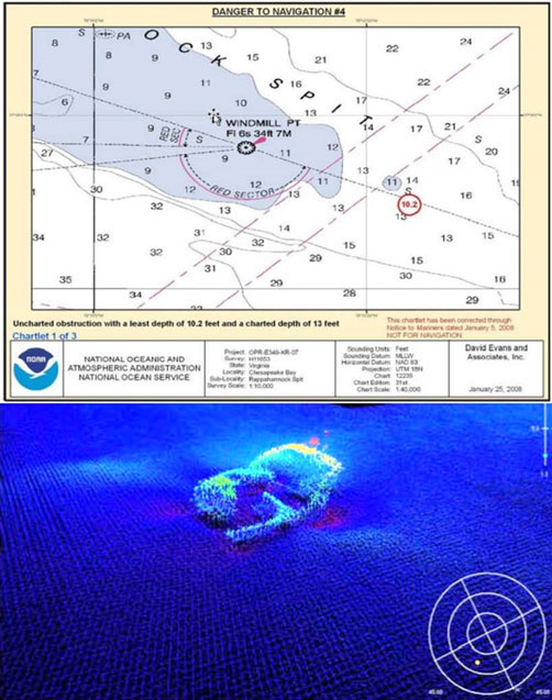
Site 15, a narrow, elongated feature about 300’ in length, is located off Stingray Point with a least depth of 10’. One could say that it’s off Rappahannock Spit, and it is in a manner of speaking. This feature is most likely the USS Katahdin, although hydrographic survey did not identify what it is.
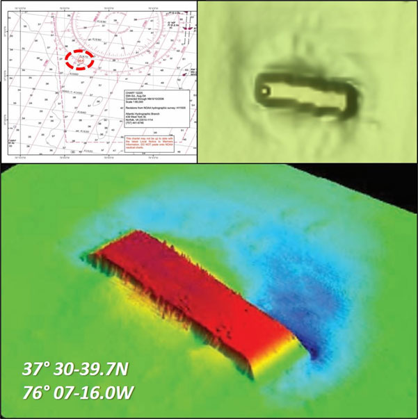
There are several features south of the spit below the area shown on Chart 1, the most interesting being a small barge wreck of interest (Image 3) nine nautical miles 109 degrees True from Stingray Point at 37’30”39.7 x 76’07”16.0. A 3D color multibeam sonar image shows the wreck intact and upside down. Here’s where digging into Descriptive Reports pays off. Not only is there a more robust image of the feature, but it’s also in higher definition which aids in assessing condition. In this case, zooming in on the image suggests that the sides are heavily covered with marine growth. Using the BDV embedded scale with the “BAG” image of this wreck shows an estimated length of 75’ and width of 20’.
There are other wrecks and obstructions in this westside portion of the main stem. Those most prominent are discussed above along with some for which imagery was available online. These features and the Windmill Point Reef as well as other artificial reefs along the westside provide an exceptionally diverse range of structure to explore and hunt for sportfish.
As well as being a regular contributor to FishTalk, Wayne Young is the author of multiple books detailing wrecks and fishing reefs in the Chesapeake Bay, Delaware Bay, and beyond. All are available at Amazon.com, and you can find his Facebook page at “Chesapeake Bay Fishing Reefs.”