After finding a “lost” artificial reef under a charted obstruction circle in Southern Maryland (Southern Maryland Mystery Reefs), uncovering a deliberately constructed artificial reef under an obstruction circle in Virginia’s Bay waters probably shouldn’t have been a surprise. But it was, especially since the reef at location “A” is one of the more precisely constructed artificial reef structures in the region. While researching the Cabbage Patch Reef (location “E”), a manmade structure suddenly appeared on my computer screen. I was working through side-scan sonar imagery using the National Oceanic and Atmospheric Administration’s (NOAA) interactive Bathymetric Data Viewer (BDV). And there it was: 23 objects in tightly spaced stacks. The hunt for more details was on.
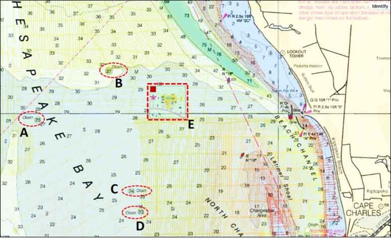
Next stop was NOAA’s Automated Wreck and Obstruction Information System (AWOIS). Although AWOIS is no longer updated, the Interactive AWOIS Viewer displays valuable information for wrecks, obstructions, nautical charts, and other data. Another surprise — AWOIS recorded the placement. A tug reported “dumping” 23 large concrete blocks in 1972. In fact, the objects were not dumped. The BDV side-scan sonar image shows that the blocks were deployed to create a massive artificial reef with substantial vertical height. Each block was 23 feet square and two feet thick. Five stacked piles of four blocks, and one stacked pile of three blocks, were constructed. The blocks in each pile were layered on top of each. They look like six sets of Baltimore row house entrance steps alongside each other.
Placement in tightly positioned stacked form cannot be accomplished without heavy-lift equipment such as a barge-mounted crane. The BDV side-scan sonar image clearly shows all 23 blocks. Sediment has piled up on the northwestern corner and a scour hole is visible at the southwestern corner. There’s as much as an eight-foot drop-off along the edges of the structure and down the steps.
A 2006 NOAA field survey found the objects at 37’09”51.63 x 76’06”28.63. Why the material was placed at this spot and who sponsored and paid for the deployment are not recorded. The reef is also not recorded in the Virginia Marine Resources Commission (VMRC) artificial reef files. It’s hard to believe that such a carefully constructed reef would have been created without a permit, but it certainly appears that this obstruction is a “bandit” reef. Best guess: some organization built an artificial reef and didn’t tell anyone about it except for the tug’s cursory report of an obstruction to NOAA. After nearly 50 years in the water, if there’s anyone left who knows about the reef’s history, they’re not talking.
Other obstructions west northwest and south southwest of Cabbage Patch Reef are at locations “B,” “C,” and “D.” Although not as dramatic as the unlisted reef, they nevertheless have enough structure to draw a few fish.
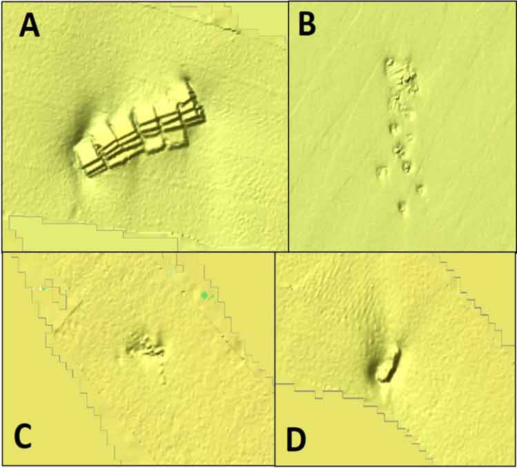
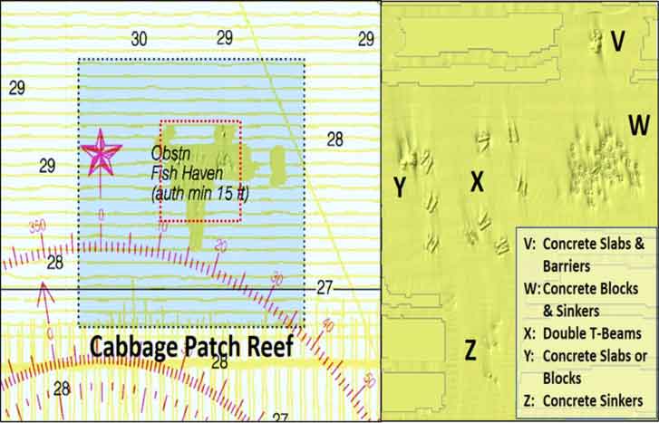
The VMRC Cabbage Patch reef is named after one of two Bay areas known as the Cabbage Patch. Both are popular fishing destinations. One is on the east side across from the Potomac River. The other is off the Eastern Shore south southwest of Cape Charles Harbor. Cabbage Patch Reef, established in 2000, is named after this latter area. The Eastern Shore Chapter of the Coastal Conservation Association of Virginia contributed to developing this fishing destination.
VMRC’s grid drawing and satellite image for Cabbage Patch Reef show considerable reef materials spread across the site. NOAA’s BDV also has partial side-scan sonar coverage. Some materials were placed after the sonar image was collected. Recent substantial deposits of bridge demolition materials are outside of BDV side-scan sonar coverage.
Comparing the VMRC and BDV data reveals that the actual location of some material varies from where recorded in artificial reef files. The BDV images should be used for the materials that are covered by side-scan sonar because they show actual configurations and layouts. Geographic coordinates can also be extracted. Coordinates for these materials are also listed in the “Virginia Artificial Reef Guide” produced by the Virginia Saltwater Sportfishing Association.
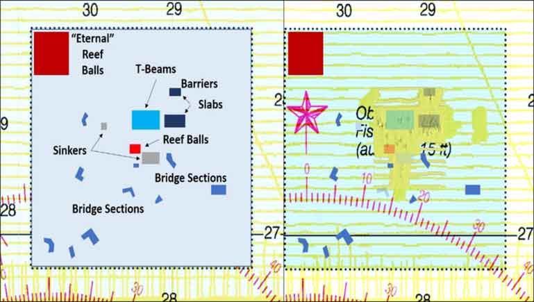
These two graphics show reef materials in relation to the site boundary. One shows the layout derived from the VMRC satellite image. This data was then placed on top of NOAA BDV data. The second graphic focuses on the BDV data to enable correlation of sides-scan sonar images with VMRC data for the objects shown.
Concrete slabs and barriers at location “V” are approximately where they are shown in the satellite image. A large group of objects which appear to be concrete blocks, sinkers, or a combination, are at location “W.” This mass of material, more or less a “smear” reef pattern, extend beyond where shown in the satellite image. The double T-beams at location “X” were placed in a large patch pattern. They are spread out well beyond the location shown in the grid drawing. At location “Y” are what appear to be concrete slabs or possibly concrete blocks. The objects at location “Z” are relatively small and are probably buoy sinkers.
Cabbage Patch Reef sits in some of the most productive fishing grounds in the Bay. In addition to the Cabbage Patch, other natural features include Latimer Shoal to the southeast, and the steep edges and holes of Cherrystone Channel. There are also a substantial wreck and obstruction off the entrance of Cape Charles Harbor. The Texeco wreck is about 2.5 miles northwest of Buoy 1CC. AWOIS records that the wreck is 200 feet long, lies in an east-west direction, and rises 15 feet off the bottom. An obstruction is located about 1.5 miles slightly north of west off Buoy 1CC. Five elongated objects oriented approximately northwest to southeast are shown in the BDV side-scan sonar image. Four of the objects appear to be partially covered in sediment. One object has well-defined edges suggesting that most of it is uncovered.
Directly east of Cabbage Patch Reef are the nine Kiptopeke Breakwater concrete ships and the Kiptopeke boat ramp. The breakwater is, in effect, a substantial artificial reef structure in terms of mass and area covered. In place since 1948, the ships are heavily weathered and relatively low to the surface. However, they attract fish and provide physical protection when conditions outside the breakwater are unsuitable for recreational Bay boats. Five miles south of Kiptopeke is the northern terminus of the Chesapeake Bay-Bridge Tunnel and all of its fishing opportunities. What can be caught at these locations? About anything with fins that swims in the Bay!
See our Chesapeake Bay Fishing Reefs Guide to get the lowdown on other mad-made wreck and reef hotspots in the Bay, plus a few in the ocean off the DelMarVa coast.
-By Wayne Young, a former manager of the Maryland artificial reef program for Bay waters and the author of “Bridges Under Troubled Waters: Upper Chesapeake and Tidal Potomac Fishing Reefs." You can also visit his Facebook page, Chesapeake Bay Fishing Reefs.
Sign up here to get the weekly FishTalk Chesapeake Bay and Mid-Atlantic fishing reports in your email inbox, every Friday by noon.