When the Office of Coast Survey, National Oceanic and Atmospheric Administration (NOAA) changed the Bathymetric Data Viewer (BDV) basemap from raster to Electronic Navigation Charts (ENC), some additional Bathymetric Attributed Grid (BAG) color shaded relief images were also uploaded. Prior to the update, it was necessary to use specialized software to view this BAG data, which really pushed the limits of computer memory. Now, readers can access the processed data using the BDV BAG Color Shaded Relief data layer. And, some interesting bottom structure features are revealed. The updated BDV also increased the clarity of BAG imaging generally. The following dozen features were observed from the BAG imaging after the update.
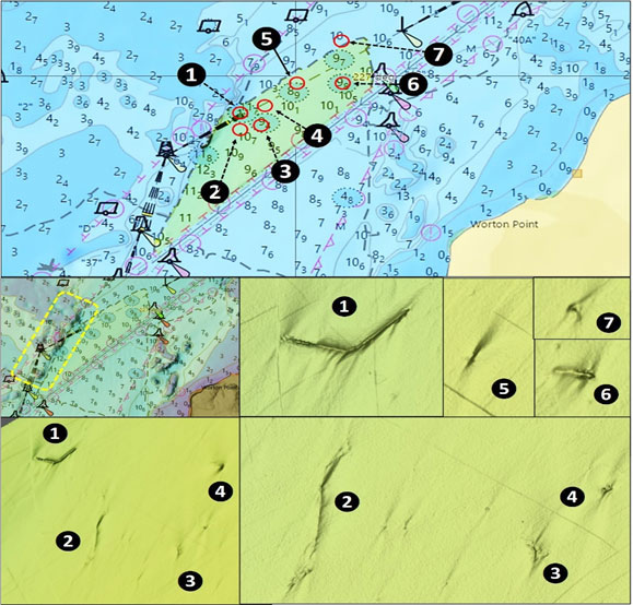
Northwest of Worton Point on the west side of the shipping channel is a potential anchorage area for ships transiting between Baltimore and the C&D Canal. The Association of Maryland Pilots was concerned that charted obstructions were no longer there or had shifted position and charted depths had changed. So, they requested that NOAA survey the area and update nautical charts with the findings. A hydrographic survey was conducted in 2018, and the multibeam sonar data collected by the survey shown on Chart 1 makes it clear that the pilots certainly made a good call.
A substantial finding from the survey is an angular linear obstruction (Site 1) southwest of Shad Battery Shoal at coordinates 38’19.852N x 76’12.382W. The feature is just east of a very rugged edge which helps channel prevailing currents. The survey didn’t characterize what the object is, and the feature isn’t listed in the Coast Survey’s Automated Wreck and Obstruction Information System. The feature is now charted as an 11-meter shoal on ENC charts. Looking at the BAG image, it presents as a long section of dredge pipe configured like a boomerang and lying on the bottom. Each leg is about 90’ long. The image shows scour along the object’s length, so it’s interacting with current flow and certainly should be worth jigging over it when in the area. Try drifting along it but note that it’s so narrow, it would be difficult to stay on top of either leg unless the wind and drift patterns were cooperative.
There are a number of other features in the survey area, marked on Chart 1 as Sites 2 to 7. Some that were formerly charted as obstructions on raster charts are now charted as shoals. Others aren’t charted. Site 2 is unknown, although the angled linear configuration suggests another possible lost dredge pipe. Site 3 is recorded as an obstruction. Site 4 is an uncharted obstruction. Site 5 was first charted in 2000 and the file records that a “Sonar image displays characteristics of a sailboat: hull outline with long, narrow shadow suggesting a mast.” Sites 6 and 7 are both recorded as obstructions. When fishing in this portion of the Upper Bay, check the fishfinder when passing these spots.
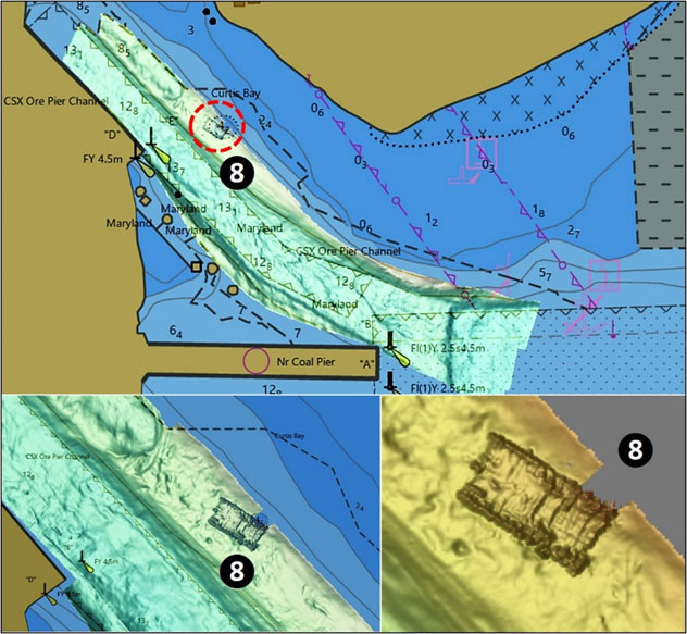
Although Curtis Bay isn’t a normal fishing destination for many anglers, the entrance to Stonehouse Cove has BAG imaging off the commercial docks. The color shaded relief image reveals a sunken barge, marked as Site 8 on Chart 2, that is charted as a 14’ least-deep obstruction. I’m not sure I would eat anything I caught in Curtis Bay, but the structure sure looks promising. Up inside the cove is very shallow – kayak water. The cove is foul with wrecks, especially on the west side.
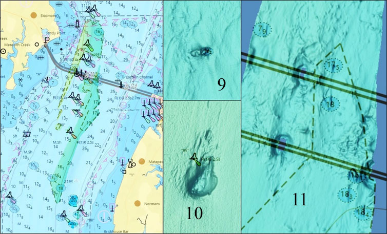
At the Chesapeake Bay Bridge there are two narrow, irregularly shaped survey areas with BAG imaging coverage. The images show some interesting features; Site 9 on Chart 3 is recorded as the wreck of an 18.5’ boat that was lost in 1973. But it measures more like 30’ long using the BDV distance scale, and is still recognizable as a boat outline. Site 10 is a huge hole immediately southeast of Buoy G “95”. It measures about 100’ long and 80’ wide. Best guess is that it’s a scour hole around the buoy anchor. The size is indicative of the strong currents that roll through the area. Site 11 on Chart 3 is a general marker for rugged bottom with obstructions and wreckage on the east side of the Bay Bridge. There’s a lot to check out at this location when targeting stripers.
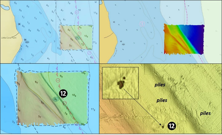
Making an even dozen, Site 12 shown on Chart 4 marks the remains of pound nets and an unknown obstruction off Cove Point. A special survey was performed to assess this area and according to the report, “There are submerged pilings off of Little Cove Point in the approximate position of 38'21.836 x 76'22.222. The location is in the area of a registered pound net, pound net site 601, which has been removed. It is also reported that a number of poles and a net remain submerged within two to three feet of the surface. There’s also a cluster of unidentified objects at coordinate 38’21.801' x 76’22.237.” The feature was charted as an obstruction on raster charts and is now shown on ENC charts as a three-foot shoal. This correlates with the poles and net described above. The pound net was located in a natural trough which funnels currents, bait balls, and schools of fish. Little wonder why the pound net was located there. But, that’s also a signal that recreational fishermen should take notice of the site as well. Having fished the spot, I can attest to the large number of piles lying on the bottom. It’s one of those spots that goes hot and cold. Whether or not the net is still there is a question. But, there is the potential for piles rising up close to the surface. So although it’s a good jigging area when fishing the west side, take care when operating in the area and be aware of the risk of snagging the piling with end tackle.
Much of the Upper and Middle Bay and also the tidal Potomac River lack BAG imaging coverage. Although a lot of the charted data is dated, there doesn’t appear to be a pressing navigational need for updated hydrographic surveys of these areas. There are also certain wrecks that aren’t specifically charted, especially in the Potomac River, due to archeological preservation concerns. There are also some uncharted wrecks and rock piles of which I’ve become aware of anecdotally and don’t publish locations as a courtesy to those who shared them privately. Thus, there’s certainly potential for more structure out there than is charted. So, keep an eye on the side-scan and down-looking sonar when passing through.
- By Wayne Young. As well as being a regular contributor to FishTalk, Wayne Young is the author of multiple books detailing wrecks and fishing reefs in the Chesapeake Bay, Delaware Bay, and beyond. All are available at Amazon.com, and you can find his Facebook page at Chesapeake Bay Fishing Reefs.