It’s a common occurrence in online fishing communities: someone pops in, likely new, and asks “Where is a good place to catch (insert fish species here)?” Let me be the first to say that there’s nothing wrong with this. The fishing community is just that – a community. Communities should share and support. Yet these folks, in all of their hopefully innocence, are often given a hard time by salty veterans resistant to sharing what they’ve learned after countless years on the water. And I get it! Nothing can take the place of experience. Money, time, and the prerequisite blood, sweat, and tears have been poured into long hours learning a particular body of water, and veterans have a right to keep that close to the vest. But if you’re thinking of fishing new water, how can you plan for your trip without getting ribbed online? Hopefully, the following five tools will give you some insight into the spot you’re curious about before you even put hull to water.
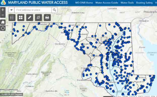
- Maryland Public Water Access Maps - Powered by the Maryland DNR, the ArcGIS version map is the most detailed, thorough, and comprehensive water access map that I have found thus far. Each blue dot represents a water access point, from sandy beach launches up through quadruple-lane cement boat ramps. Clicking a dot opens a window which provides details about the launch size, parking lot size, ramp surface, hours, and helpful information such as a website, phone number, and governing body in charge of the ramp. This website is a game changer, whether you want to access a familiar body of water from a new location or want a new adventure in a completely different part of the state.
- Virginia Public Water Access Maps - When searching out Virginia waterway access, visit the Virginia Department of Game & Inland Fisheries website where they have a Public Boating Access search field (no map) searchable by body of water or by county and city. You can also find listings of coastal and Bay launches in the Virginia Marine Resources Commission Saltwater Angling guide online.
- Google Earth and Google Street View - This is not a new tech for most, but it’s grossly underrated as a scouting tool for fishing spots. Most of the time, there’s no way to know what type of water, structure, current, or shoreline you’ll be fishing until you have your boat in the water. With Google Earth, that changes. Download this free add-on and immediately you can zoom in so far that you can practically see the five-pound largemouth hiding under that log. Additionally, for anyone curious about a new ramp’s size or parking, you can utilize the “Street View” feature of Google Earth to put you on the ground at most known spots for a pavement-level perspective of the area you want to check out.
- Navionics Web App - The paid version of Navionics is used widely by tens of thousands of boaters and fisherman for accurate navigational and depth information. Even though it’s not as detailed, the free version of Navionics is also a fantastic way to nail down points, shoals, flats, humps, and drop-offs before setting off on the day of your trip. Some of the information isn’t fully accurate, so don’t use the free version as your main navigational tool. However, when you’re heading out to fish new water, this version does provide you with at least a strong idea of what bottom contours you can expect. It’ll point you in the right direction so that you aren’t aimlessly paddling your kayak or burning fuel in order to find your desired depth and structure. While it covers primarily the ocean and the Bay in our area, there are also some lakes mapped.
- Online Forums - Chances are, you’re not the first person to have a particular question about a location or species. Most forums, such as Stripers Online and Tidal Fish, can be searched for previously posted content without having to join the forum itself. Often, the response to a question is for a senior forum member to link the newbie to a conversation when the question was asked previously. That’s a lot of time and effort to be put in when a quick search could have yielded the same results. So, research before you post. If then you still aren’t satisfied, well, it’s probably time to join the forum and become a part of these fishing communities.
- Weather Apps - FishWeather, Windfinder, Windy, live buoy data, and regular old weather apps are both smart and safe resources to use before entering new water and can help you decide which part of a waterway to fish prior to launching. This is particularly true if you’re in a smaller boat or kayak and are entering big water that’s new to you. Check multiple sources for the direction and intensity of forecasted wind, waves, and weather, and have a backup plan in case things go awry. Often, if the weather is looking sketchy it’s smart to have a couple backup launches which may afford you a quicker escape if the weather turns. For kayakers in particular, learning about the “fetch” of waves is vital. If you’re on the western shore of the Bay and there’s an eight-mph breeze from the west, you’re probably sitting pretty on some lightly rippling water. But switch that breeze to the south on an outgoing tide, and you could be in a washing machine. New water is exciting but no fish is worth your life, so checking weather apps and making a backup plan for your trip is crucial.
Your best bet is to use all of these tools in combination. Some may be more helpful than others, but hopefully they can help you make the most of your time when you set off in search of new waters and new memories.
- By Matt Stone
Sign up here to get the weekly FishTalk Chesapeake Bay and Mid-Atlantic fishing reports in your email inbox, every Friday by noon.