The sky was clear and visibility unlimited on a dark October night in 1978, when the Coast Guard Cutter Cuyahoga was lost in the Chesapeake Bay’s main stem off Smith Point. The 51-year-old, 125-foot-long cutter was on a training cruise with officer candidates from the service’s training center in Yorktown. The skipper, preparing to turn into the Potomac River to lay over for the night, misread the navigation lights of an approaching outbound coal ship. His turn to port towards the mouth of the river put the cutter broadside to the approaching ship’s bow. Known in the service as a “buck and quarter,” the cutter was no match for a 521-foot-long dry bulk cargo vessel.
Observing the cutter turn across his bow, the marine pilot ordered emergency maneuvers, but that wasn’t enough to prevent a collision. The ship sliced into the starboard aft quarter of the cutter. Cuyahoga was driven onto her side before breaking free and sliding down the starboard side of the ship, quickly sinking with loss of life. The loss of fellow Coastguardsmen hit us hard. I served a training assignment aboard a sister cutter out of Cape May a decade earlier and knew the cutter’s belowdecks configuration. That some of the crew and trainees escaped was a miracle. The cause of the accident, human error, was a wake-up call for all of us.
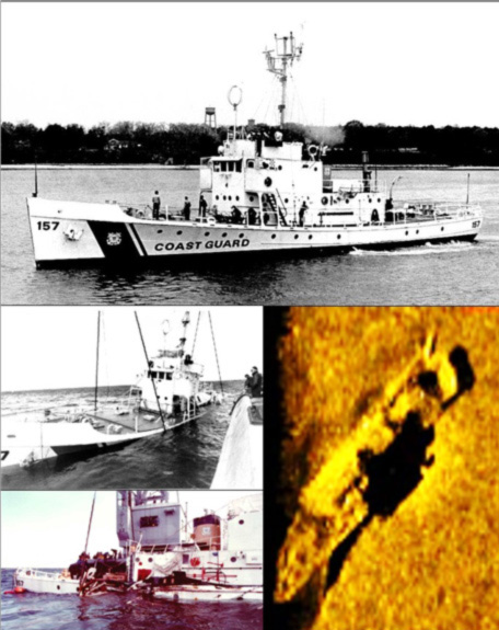
Today, Cuyahoga serves as marine habitat and fishing structure at Virginia’s Triangle Reef. The cutter was raised from the bottom for the Coast Guard’s marine casualty investigation, but too badly damaged to repair, she was then sent back to the bottom at the fish haven. The location, just south of the southern boundary, is shown in the Virginia Marine Resources Commission’s (VMRC) layout grid and Geographic Information System (GIS) map. The hull is shown as intact in a 2010 VMRC sonar report and a color-shaded bathymetric relief image from the National Oceanographic and Atmospheric Administration’s (NOAA) Bathymetric Data Viewer (BDV).
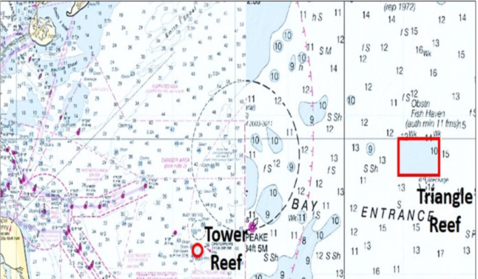
The Triangle Reef was permitted as a fish haven in 1971 by the U.S. Army Corps of Engineers. It is a three-by-two-mile square reef site over 16 miles from the Chesapeake Light Tower as shown on the chart. According to a 1983 paper prepared by Jon Lucy for the Virginia Institute of Marine Sciences (VIMS), the fish haven was sponsored by the Tidewater Artificial Reef Association of Virginia (TARAV). The association grew out of the Boating and Sportfishing Committee of the Norfolk Chamber of Commerce. Several wrecks from World War Two, the Lillian Luckenbach and John Morgan, were already within or in close proximity to the reef boundary.
Wartime marine security measures at the Chesapeake Bay entrance resulted in minefields and a single channel marked by center lights rather than red and green channel buoys. The center light configuration facilitated sweeping for mines laid by German U-boats. On the night of March 27, 1943, the 448-foot-long freighter Lillian Luckenbach was outbound with other ships from Lynnhaven Roads with a cargo including tires, trucks, and airplane wings. While proceeding through the channel single file, she collided with an inbound ship, was severely damaged, flooded, rolled on her side, and sank. A temporary channel dogleg was established around her until she could be removed.
On June 1, 1943, just after midnight the Liberty Ship John Morgan, escorted by a Coast Guard cutter, was outbound single file with several other ships to join a convoy. The ship was loaded with tanks, trucks, jeeps, motorcycles, tractors, food, machine guns, ammunition, high explosive shells, TNT, smokeless powder, P-39 airplanes, flammable ingredients for aviation fuel, and toluene. She was a floating bomb. Another group of ships including a loaded tanker was inbound led by an escort that had missed diversion orders due to communications issues. They weren’t supposed to be there.
As the tanker and the John Morgan approached the Luckenbach dogleg, the tanker’s escort sighted the outbound Liberty Ship and warned the tanker to no avail. The ships collided at the dogleg. Fire immediately broke out on the surface. Within minutes, the John Morgan suffered a massive explosion and sank. The tanker caught fire, but was later saved. Salvage of both the Lillian Luckenbach and the John Morgan and their cargoes was not attempted. Both were dragged by wires to their present locations. When fishing the site, keep in mind that the John Morgan carried munitions, visually observed by divers as scattered around the site. If anything resembling ordnance is snagged and retrieved while fishing, don’t bring it aboard. Better to lower it gently back down below the surface and cut it off.
Development of Triangle Reef began in 1972. TARAV initiated an effort, in cooperation with federal and state agencies and legislators, to secure and deploy mothballed Liberty Ships as artificial reefs. This led to federal legislation authorizing the release of surplus ships to states for use as artificial reefs. Virginia requested six surplus Liberty Ships in 1973. An Environmental Impact Statement was found acceptable. The Virginia Legislature allocated unrefunded marine fuel taxes for use by VMRC to develop the artificial reefs. The six ships were released to the State in 1974. To enhance their suitability for fishing, deck gear was removed, and the hulls were cut down to just above the second deck. Four were deployed at Triangle Reef (the other two were deployed at the Paramore Reef).
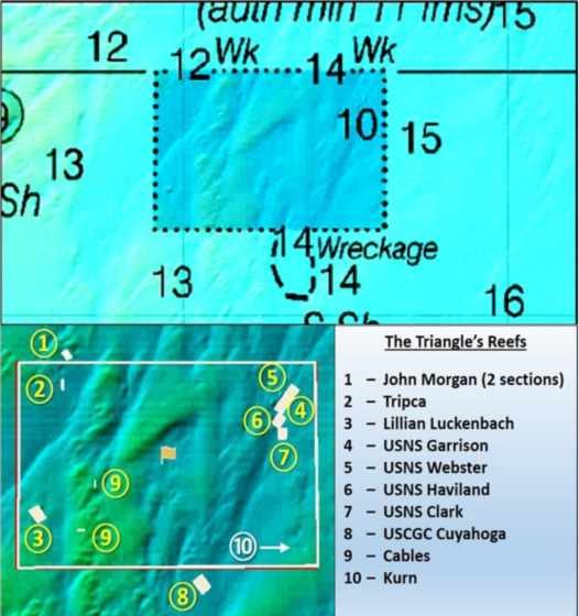
All of the aforementioned wrecks comprise the majority of the fishing reefs. Side-scan sonar, like NOAA BDV screenshots, clearly show the structures. Graphics show the very rugged bottom just outside the northwest corner of the fish haven where at Location “1” lie the remains of the John Morgan and her cargo in two sections. At Location “2” are the remains of the Tripca. No additional information is available about this wreckage. However, it has the appearance of a wooden vessel frame.
The wreck shown at Location “10” was reported in 1988 by a Navy ship. It is recorded as an unidentified 180-foot steel hulled vessel by the Coast Survey’s Automated Wreck and Obstruction Information System (AWOIS). The hull is broken in half and surrounded by several areas of debris. The wreck, a popular dive site, has been characterized as both a navy tanker and ocean-going tug due to a lot of towing gear in the vicinity. Recreational divers in the Tidewater area identified her as the Kurn. A sunken landing craft is also reported by divers in the immediate vicinity.
The large structures at the Triangle Reef hold fish all year. Commonly anglers will look for tautog in the winter, sea bass most of the year, and triggerfish and flounder during summer months. Out at the Triangles, however, there’s a plethora of species one might encounter on any given day.
Triangle Reef GPS Coordinates
The reef’s center lies at 36’59.0 x 75’22.9. Using geographic coordinates recorded in the VMRC layout grid as waypoints will get boats close to these structures, but GPS and fishfinders must be used to get directly over them for effective fishing. Coordinates for wrecks and obstructions for this fish haven are also recorded in the Virginia Saltwater Sportsfishing Association’s Virginia Artificial Reef Guide. Proceeds from sale of the guide supports reef development now that public funding is less available, so anglers in search of more detailed coordinates should visit the VSSA website and join.
See our Chesapeake Bay Fishing Reefs Guide to get the lowdown on other mad-made wreck and reef hotspots in the Bay, plus a few in the ocean off the DelMarVa coast.
- Wayne Young is the author of “Bridges Under Troubled Waters: Upper Chesapeake and Tidal Potomac Fishing Reefs,” and “Chesapeake Bay Fishing Reefs, Voyage of Rediscovery.” Both are available at Amazon, and you can find his Facebook page at Chesapeake Bay Fishing Reefs. Look for his new books, “Phantoms of the Lower Bay” and "Hook, Line, and Slinker."
Sign up here to get the weekly FishTalk Chesapeake Bay and Mid-Atlantic fishing reports in your email inbox, every Friday by noon.