“You can find a lot just by looking,” Yogi Berra, the master of understatement, once said. Such sentiment is often true – although not so much for York Spit Reef. A grid drawing on the Virginia Marine Resources Commission (VMRC) artificial reef website shows general layout by material type, and August Fish Spots: York Spit Area, a 2014 article in PropTalk Magazine, mentions the reef while discussing how and where to fish in the area. But as far as published reef information goes, that’s about it. The reef site was not one covered by VMRC sonar reports, reef details are not included on the VMRC satellite image webpage, and it’s outside the coverage of National Oceanographic and Atmospheric Administration (NOAA) side-scan sonar Bathymetric Data Viewer (BDV). Yet, the reef site is well located in a great fishing area, is readily accessible from the Middle Neck and upper Tidewater areas, and has a lot of excellent vertical reef structure to explore.
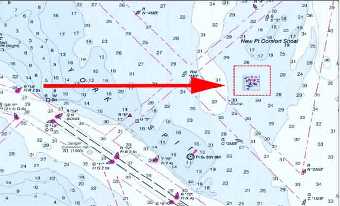
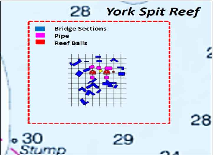
Located between York Spit and New Point Comfort Shoal, the reef site is close to the shoal’s elongated, low-relief bottom ridges. Current predictions for this area suggest that the ebb and flood currents move through the low spots between the ridges towards and away from the reef site. The center point is about 2.5 miles north northeast of York Spit Light. Reef materials are concrete pipes, reef balls, and bridge sections. The concrete pipes donated by Hanson Pipe Company were placed in 2001. They were “nested”pipe, that is, pipes of different sizes were placed inside larger pipes. Then they were lowered to the bottom by a barge-mounted crane. The actual layout is uncertain. Semi-circular patterns were used for nested pipes donated by Hanson at other VMRC reefs during the period. So, recreational fishermen should not be surprised if this type pattern shows up on side-scan sonars. Reef balls were also deployed during 2001. Later, between 2003 and 2005, a large quantity of bridge sections donated by Tidewater-Skanska Corporation were also deployed. Overlaying the VMRC grid drawing on a nautical chart shows approximately where the materials are located within the site. The shapes inside the grid are approximate perimeters for specific materials. However, irregular patterns using various reef forms is typical of VMRC artificial reefs, and should be expected. Geographic coordinates can be extracted from the grid drawing, but how these coordinates were taken is not indicated. Even if early Global Positioning System (GPS) data were used, the GPS error factor was somewhat larger back then, although much less than for Loran C. So, allow for position error while exploring the site.
If the natural bottom features and reef aren’t producing, there are nearby wrecks and obstructions to check out. NOAA’s Automated Wreck and Obstruction Information System (AWOIS) has minimal to no information for most of what is charted nearby. Several exceptions include a wreck with barge-like dimensions and a 400-foot long dredge pipe, shown as locations “A” and “B” in the graphic.
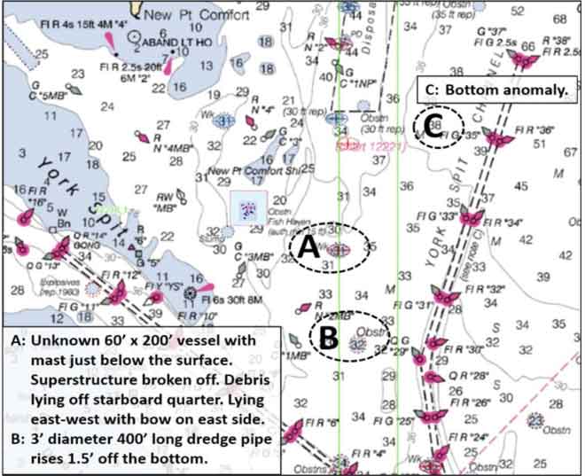
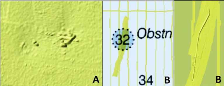
As luck would have it, NOAA did some spot investigations that are revealing and there are BDV images for both objects. The wreck at “A” is in the middle of the wreck circle. The sonar image shows that it’s broken up and scattered. The dredge pipe at “B” is oriented slightly offset from north-south and extends outside the obstruction circle. Although low relief objects, they are nevertheless anomalies that could draw in prey and predators. There is also an uncharted anomaly at location “C”. It’s small and low relief, but might be worth a look if passing by. The feature is west northwest of Buoy G “35”. BDV coordinates are 37.267° N, 76.140° W.
The Virginia Artificial Reef System is well developed and the state reef sites contain some really neat stuff, well located in relation to physical conditions and often in or near fishing hot spots. York Spit Reef is no exception. Light tackle fishermen should keep this one on the “give it a look” list, when fishing in the Tidewater area.
See our Chesapeake Bay Fishing Reefs Guide to get the lowdown on other mad-made wreck and reef hotspots in the Bay, plus a few in the ocean off the DelMarVa coast.
-By Wayne Young, author of Bridges Under Troubled Waters: Upper Chesapeake and Tidal Potomac Fishing Reefs. His new book, Chesapeake Bay Fishing Reefs, Voyage of Discovery, was just recently released this winter. You can find his Facebook page at Chesapeake Bay Fishing Reefs.
Sign up here to get the weekly FishTalk Chesapeake Bay and Mid-Atlantic fishing reports in your email inbox, every Friday by noon.