The DelMarVa Peninsula’s Chester River, a major Chesapeake Bay tributary, runs about 43 miles from the entrance off Love Point past scenic small towns, villages, and farmlands. It’s navigable upstream to the fixed bridge at Crumpton, MD, through waters that once supported a thriving oyster fishery. Remnant oyster reefs and oyster restoration sites along the way provide spots to prospect for striped bass.
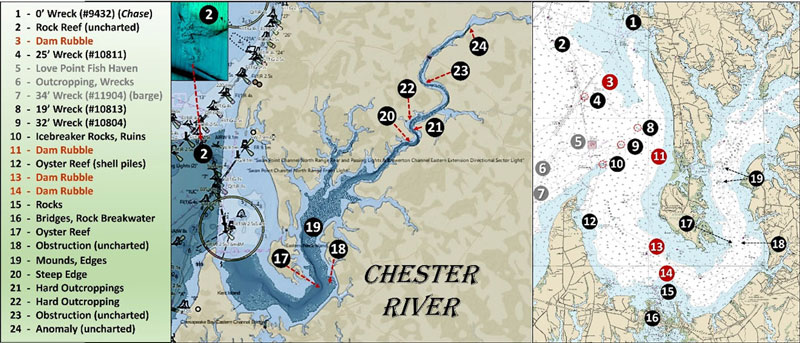
Finding structure is aided by recent Bathymetric Attributed Grid (BAG) Color Shaded Relief that was uploaded to NOAA’s Bathymetric Data Viewer. Dark-shaded areas on both sides of Love Point shown on Chart 1 are areas covered by the new BAG data. Although BAG coverage is mostly partial and focused on the channel, some interesting structure is revealed from just inside Love Point upriver to just below Possum Point.
Site 1 on Chart 1 north of the Chester River entrance is where we’ll find remnants of the Coast Guard training barque Chase. It’s located at the mouth of Swan Creek leading into Rock Hall Harbor at coordinates 39°08.42 x 76°15.76. The site is of particular interest to me having trained aboard a successor, the Coast Guard’s barque Eagle. The earlier 106’ sailing ship began service in 1878. Later, Chase was cut in half and lengthened to 124’. After serving 30 years, the cutter was decommissioned in 1907. The vessel thereafter became a quarantine ship operated by the U.S. Marine Hospital Service and was later reconfigured as a detention barge. No longer fit for service, the hull was grounded as a breakwater for the marina at the mouth of Swan Creek. Today, this once proud cutter is still there just south of the marina’s updated protective structure. The underwater outline of the forward half of the vessel can be seen in satellite images taken on a clear day; try casting to the wreck when passing by.
An uncharted hard outcropping at Site 2, the “real” Swan Point from eons past, protrudes out into the bend of the ancient Susquehanna riverbed. The reef is oriented north northwest to south southeast and is about 400 yards long and 125 yards wide. The northern half is most prominent with depths that slope north to south from about 25’ down to 45’. The southern half is less pronounced with depths from about 45’ to 55’. The orientation and configuration disrupt the current flow creating subsurface turbulence and favorable foraging conditions for striped bass.
Sites 3, 11, 13, and 14 mark locations where dam demolition rubble was deposited to create artificial reefs supporting oyster restoration. Simkins Dam and three others were removed from the Patapsco River between 2010 and 2019 to open up 65 miles of free-flowing river habitat for American and hickory shad, blueback herring, striped bass, and American eel. Site 3 at coordinates 39°05.99 x 76°16.95 was the first deposit using processed concrete and granite from Simkins Dam. The rubble chunks were deposited on firm flat bottom with one to three feet of vertical relief and then seeded with oyster spat on shell. Additional demolition materials were placed at the other sites. Site 12 is a much earlier oyster restoration project dating from at least 1999 consisting of four clusters of oyster shell piles. Look for the charted 500’ radius charted circle marking the restoration site.
Love Point Fish Haven at Site 5, a broad area of hard outcroppings on the west side of Love Point at Site 6, and a barge wreck at Site 7 are shown for general reference. This brings us to Site 8, a 19’ least-depth wreck at coordinates 39°04.667 x 76°15.507. This unidentified wreck was found during a 1999 hydrographic survey. A very grainy side-scan sonar image in the survey Descriptive Report shows a small, rectangular, low-profile wreck. A 32’ least-depth wreck marked as Site 9 that was also found by the 1999 survey is at coordinates 39°04.108 x 76°16.235. Another grainy side-scan sonar image shows a low-profile hull.
Site 10 is the icebreaker rockpile that was placed around the screwpiles that supported the former Love Point Lighthouse, the base of which is in ruins at the center of the feature. Today, it’s a popular fishing hotspot. Try casting or live-lining here as well as at the adjacent navigation light structure.
Moving south to Site 15, look for two clusters of charted subsurface rocks and a single charted rock off the northwest side of Long Point, and another cluster of rocks off the northeast side of the point. Charted water depths are about three feet. Site 16 is a general marker for the two Kent Narrows bridges and their various structural components. Check these features for stripers when the current is running
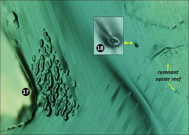
Be sure to visit the substantial historic oyster reef marked as Site 17 on Image 1. It surrounds and extends north of Chester River channel buoy 11. The reef is about 600 yards long and up to 200 yards wide. There’s as much as five feet of vertical relief. Least depth is around 22’. Prospect here taking full advantage of side-scan sonar to locate foraging stripers. Also try working the edge of the shelf around the lower end of Eastern Neck Island, which has great scenery and wildlife viewing opportunities plus shallow-water areas for kayak fishers to target.
East northeast of the buoy across the channel at Site 18, coordinates 39°00.808 x 76°11.023 is an unidentified, uncharted obstruction. It measures about 20’ long and sits in a scour hole (Image 1 insert). Southwest of Chester River Channel Buoy 12 about 200 yards southeast of Site 18 is a low relief remnant oyster reef with about 15’ of depth. Try drifting across it for spot and white perch.
Proceeding upriver, Site 19 is a general marker for scattered oyster reef remnant mounds, several very hard shoals, a sharp edge on either side of Chester River Channel Buoy 14, and a large remnant oyster reef northeast of Piney Point. The latter parallels the river channel for about 1500 yards and is about 400 yards wide. The southwestern end is the most prominent section and is centered around coordinates 39°03.203 x 76°11.778. The charted shoal circle doesn’t convey the full expanse of this rugged oyster bottom. Least depth is 14’ with vertical relief of up to six feet on top of the shoal. The northwest edge drops off sharply about 10’. This is another spot where side-scan sonar can earn its keep when prospecting for stripers.
Site 20 marks a very steep edge that’s about 1000 yards long and on the north side of the river channel southeast of the mouth of Jarrett Creek. The river channel runs along the base. Depths drop from 11’ on top of the edge down to over 45’ in under 75 yards. Try trolling, casting, or jigging depending on the prevailing conditions.
Just upstream at Site 21 on the northeastern side of the river, look for two prominent narrow reefs centered at coordinates 39°08.851 x 76°04.643 and 39°08.648 x 76°04.750. But looks are deceiving here. The deepwater channel curves around the north end of the upstream mound and is squeezed between it and the channel edge, creating a narrow gorge. This mound has a least depth of 20’ and drops off sharply over 15’ along its northeastern edge. Based on their mass and positioning, a best guess is that these are rock outcroppings that were colonized by oysters. When the ebb is running, the current flow splits around the southern mound which has deep water on both sides. If a sign were posted here, it would say “Fish Me!”
Chugging further upstream into the next bend, look for more outcroppings along the steep northern edge of the riverbed starting southeast of the mouth off Browns Creek. Site 22 at coordinates 39°09.037 x 76°04.829 marks a sharp turn in the ancient river gorge around a now drowned bluff. The remaining large mound obstructs and disrupts current flow creating turbulence and upwelling.
Upriver at the northern end of Devil’s Reach, coordinates 39°10.954 x 76°03.684, partial BAG coverage reveals an uncharted obstruction with a least depth of about 17’ that appears to rise several feet off the bottom. The feature is about 80’ long and 20’ wide, and perpendicular to the riverbed with scour trails on both sides. It could be an outcropping or maybe a wreck. Regardless, it’s worth checking for stripers.
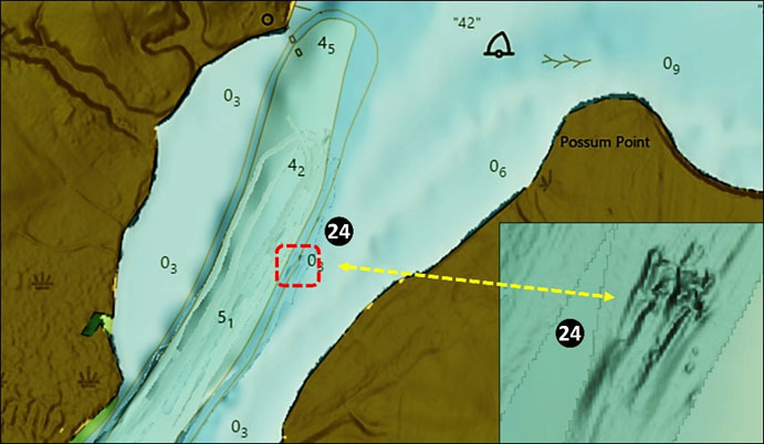
Upon reaching Chestertown, try jigging the many concrete bridge piers for stripers. Just downriver about 60’ BAG Color Shaded Relief reveals debris from demolition of the old Chestertown Bridge are strewn on the bottom where this wooden bridge once stood. The final feature on this trip up the Chester is another uncharted feature marked as Site 24, at coordinates 39°14.059 x 76°00.842. Least depth is about four feet, sloping down to about 10’ in the channel. There is something hard here that produced a scour trail leading downriver. Best guess is that there’s a hard ledge right on the bottom.
Above this point in the upper freshwater reaches of the Chester River you’ll find species including catfish, perch, largemouth bass, crappie, and occasional stripers which, during the spawning run, come upstream as far as Millington. The Chester River has a lot of structure that offers fishing opportunities throughout as it meanders to the Bay.