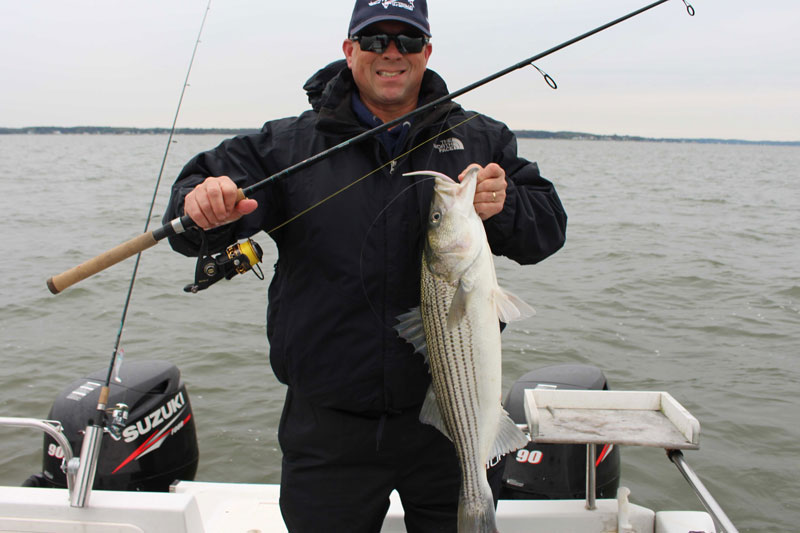
Oyster bars are the spots to go for tasty seafood and in the case of striped bass, that means crabs, bay anchovy, Norfolk spot, and peanut bunker. Unfortunately, natural oyster bars today are but a shadow of their former dominant role as a keystone species in Chesapeake Bay. Nevertheless, live oyster bars, oyster bar remnants, and oyster replenishment and reef restoration projects such as found off Cook Point in the Choptank River are prospective hotspots for recreational light-tackle fishing. Understanding where to look for them is a stepping-stone for building local knowledge and a playbook of fishing destinations.
Oysters are a form of primitive bivalve with global distribution. They are a keystone species of benthic filter feeders in temperate estuaries and coastal bays. An oyster’s filtering capabilities enables it to remove large quantities of plankton, nutrients, bacteria, and sediment from the water. A healthy adult oyster can filter 25 plus gallons of water per day. A large, healthy oyster population can improve water quality.
Oyster Reef History
The Chesapeake was characterized by extensive native oyster reefs with substantial vertical relief prior to European settlement and aggressive oyster harvesting thereafter. Eastern oyster larvae have a preference for oyster shell as substrate, although they will attach to almost any hard substrate, referred to as clutch. Larvae of this oyster species swims near the surface which contributes to vertical reef development — nature’s way of keeping oysters above bottom sediments, putting them in cleaner water where nutrients essential to their growth circulate in the water column.
Oyster harvesting by Native Americans was at levels that did not adversely affect self-sustaining oyster populations. All that changed after colonization and as a consequence of aggressive commercial oyster harvesting. Today estimates are that the oyster population is only about one to two percent of the historic distribution. With a seemingly endless supply of natural resources, little to no thought was given to long-term adverse consequences. Most natural oyster reefs composed of oyster shell substrate were progressively worn smooth by mechanical dredges.
Sedimentation and deteriorated water quality have had adverse impacts as well. For example, many old oyster reefs are buried under sediment in the upper Bay. Parasitic diseases such as Dermo and MSX have also adversely impacted oysters. Although not toxic to humans, the parasites can kill an oyster at about the time it grows to a harvestable size. Oysters are susceptible to other diseases as well and can also ingest other pathogens and toxins that are in the water. So, improving water quality is an important issue.
Massive investment in the restoration of wild oysters has begun to show some promising signs of a slow recovery. Additionally, commercial ventures have developed ways to grow oysters in floating cages, which also contributes to locally improved water quality.
Finding Oyster Reefs
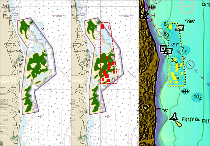
Historically, oyster bars were surveyed, named, and charted. Bar names and locations can be viewed online using interactive Geographic Information System (GIS) maps at both Maryland Department of Natural Resources (DNR) and Virginia Marine Resources Commission (VMRC) websites. However, oyster bar boundaries don’t show the actual location and configuration of oyster reefs within it. There are several ways to determine where the reefs or shell deposits are actually located and their shape.
Various field investigations and studies have been performed in Maryland and Virginia for oyster propagation and restoration. Studies of interest for fishing destinations are those that map bottom composition. For example, researchers at the Virginia Institute of Marine Science (VIMS), College of William and Mary, mapped out the extent of oyster reefs in the James and Rappahannock Rivers. These works show where various shell deposits are located and their approximate area of coverage. In Maryland waters the DNR’s “Oyster Management Review: 2016-2020” is particularly helpful for drilling down into detail because it includes an appendix which shows oyster reef configurations inside charted oyster bar boundaries.
Another method to find bars is to scan shallow nearshore areas using Google Earth satellite imagery, including historic imagery which sometimes was taken during more favorable conditions than recent or current images. Constructed oyster bars are visible at some locations. For example, a large constructed oyster bar can be discerned in Virginia’s Yeocomico River.
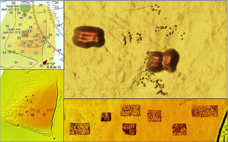
The graphic of Plumb Point bar combines historic oyster bar, nautical charts, color shaded relief, and artificial reef graphics to illustrate the relationship of oyster reefs to surroundings and to highlight why certain areas become fishing hotspots. The left insert shows an overlay of a partially transparent version of the reef configuration over a nautical chart to provide a geographic frame of reference. The middle overlays a drawing of the fish haven’s artificial reef layout. The right insert is a color-enhanced screenshot of Digital Elevation Models (DEM) Color Shaded Relief and Electronic Navigational Chart (ENC) under a drawing of the fish haven layout.
A traditional striped bass trolling area is sandwiched between the southwestern and southern edges of the fish haven and a bowl between two submerged points that coincide with natural shell deposits as well as artificial reef shell deposits just inside the fish haven. The trolling lane extends from there south through another bowl between the middle and lower submerged points. The presence of oyster bars in conjunction with the bathymetric contours is a great example of what to look for when scouting for structure that’s favorable to predator foraging.
Rock deposits hold live oysters, and striped bass hunt prey at oyster reefs. So, natural rock deposits and outcroppings are also desirable features to look for. For example, there are numerous such outcroppings off the east side of Point Lookout. “Oyster rock” is an early characterization of dense concentrations of oysters in reefs with vertical relief, resembling large rock piles. Some of the named rock locations in the Bay such as Butlers Rock (northeast of Point Lookout) and Jobs Rock (in Cornfield Harbor) may be actual rock, oyster rock, or a combination of natural rock and oyster formations.
Further Developments
Man-O-War Shoal off southeastern Baltimore County, Gales Lumps off Tolchester, and shoals east and southeast of Pooles Island are old oyster reefs consisting of “relic” shell deposits. Though they don’t support populations of live oysters they do provide excellent structure that attracts fish. The shoals off Pooles Island and Tolchester were a primary source of dredged shell clutch for the DNR’s oyster restoration program. Many deep dredged trenches were cut there to recover the buried oyster shell.
Shell dredging for clutch was terminated after public outcry against the removal of relic shell. However, the controversy renews every few years with proposals to dredge areas like Man-O-War Shoal to support oyster replenishment of wild oysters (and subsidization of watermen in the process). Shell dredging would change the character of the last remaining large natural shoals in the upper Bay.
Editor’s note: In recent years, projects incorporating CCA Maryland reef balls seeded with oyster spat to create three-dimensional oyster reefs have proved immensely successful. We’re not calling these reefs “immensely successful” merely because there are oysters thriving there, but because the fishing at these sites can be fantastic!
- By Wayne Young. As well as being a regular contributor to FishTalk, Wayne Young is the author of multiple books detailing wrecks and fishing reefs in the Chesapeake Bay, Delaware Bay, and beyond. All are available at Amazon.com, and you can find his Facebook page at Chesapeake Bay Fishing Reefs.