Previously we looked for rock formations in the Upper and Middle Bay and this month we pick up that theme off Cedar Point, where there are excellent online sonar resources that facilitate the scoping of bottom structure.
Cedar Point to Point No Point
Hard structure at Cedar Point extends northeast from the visible lighthouse ruins including remains of riprap shore protection that formerly ringed the point. If the ruins aren’t producing, try the eastern edge including the charted 17-foot barge wreck. A Teledyne CARIS 3D image of the wreck contained in National Ocean Service Description Report suggests that the barge hull is largely intact, or at least was up until a little over a decade ago. The object could possibly be deck cowling, cargo, or perhaps a collapsed spud. Regardless, it’s interesting structure that shouldn’t be overlooked, even when the ruins are hot.
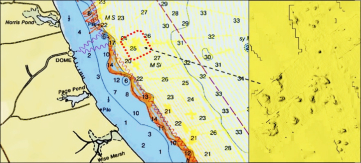
Inshore from the lighthouse ruins there are various spots that sometimes produce. Trips with professional guides are how I learned where to find schoolie stripers along the shoreline. Farther south starting at about Norris Pond, there is a very rugged underwater shelf with scattered rocks and outcroppings (see Chart 1). The entire area is within “BAG” imaging. Look for underwater ravines and rocks that run along the shoreline all the way down to Point No Point. About halfway between Norris and Page Ponds, look for an area of scattered rocks. The yellow shaded areas in the image that peek through the chart are all rock formations.
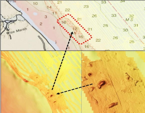
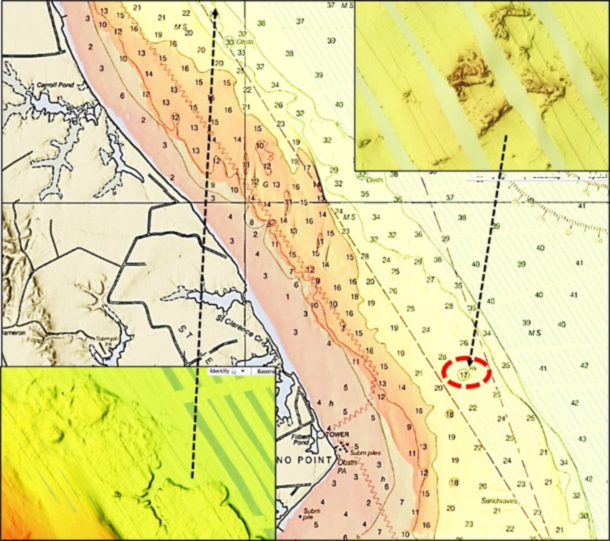
A rock cluster is southeast of Wise Pond (Chart 2). The largest, a substantial 17-foot rock outcropping, is charted just east of the southern end of the shelf and north of Point No Point (Chart 3). Although “BAG” coverage is partial, there’s enough shown to determine that the main part of the rock formation is about 150 yards long and 120 yards wide.
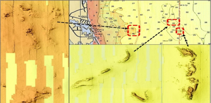
Point No Point to Point Lookout
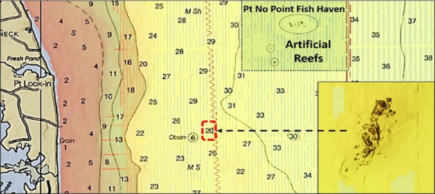
Just southwest of the Point No Point Fish Haven is a charted obstruction. There’s not much there inside the obstruction circle. However, just east of the obstruction is an uncharted hard outcropping that is hidden under a sounding number (Chart 4). Various structure around the Bay presents in a similar manner under the BDV translucent nautical chart. From there south to Point Lookout, look for a large number of outcroppings. Best guess: these are natural rock rather than “oyster rock,” that is, remnants of oyster reefs, notwithstanding oyster colonization of the rocks. These rugged features survived the onslaught of mechanical oyster dredging, which argues for hard rock rather than brittle “oyster rock” composed of oyster shells.
Just outside and due east of Tanner Creek are a number of outcroppings (Chart 5). The most prominent include one shown on some early charts as Butlers Rock, Hotel Rock (a local name), and one east of the tip of Point Lookout which I refer to as Sanctuary Rock. Of these, only Hotel Rock is charted as an obstruction (it extends outside the charted obstruction circle). All three have substantial bottom structure with good vertical relief that numerous species of fish forage. The first two are farther off the beach and tend to have a better class of fish. Sanctuary Rock is located inshore within a charted oyster sanctuary.
Jobs Rock, an area of rocky bottom on the west side of Point Lookout, is outside of “BAG” image coverage. Several rocks are charted and these also attract a great mix of sportfish species. Look for other rocks using electronic charts with tight bathymetry contours, such as the Navionics sonar charts. The high spots are the rocks. As a further note about outcroppings, some are charted as rocks, some as obstructions, and some are not shown on charts, including some substantial bottom formations.
Across the Bay from Point Lookout are natural shoals at Buoys R 72 and R 72A. They are rugged and possibly may contain some rock. At R 72A there is a wreck just south of the buoy. At Buoy R 72, the natural formation juts well out into the deep-water channel, the old bed of the Susquehanna. This disrupts the current, which contributes to making the area another excellent fishing hotspot.
- By Wayne Young, the author of “Bridges Under Troubled Waters: Upper Chesapeake and Tidal Potomac Fishing Reefs,” “Chesapeake Bay Fishing Reefs, Voyage of Discovery,” “Phantoms of the Lower Bay,” and “Hook, Line, and Slinker.” All are available at Amazon.com, and you can find his Facebook page at Chesapeake Bay Fishing Reefs.
Sign up here to get the weekly FishTalk Chesapeake Bay and Mid-Atlantic fishing reports in your email inbox, every Friday by noon.