Visiting Chincoteague has been in the back of my mind ever since first hearing about the Virginia Capes. It’s a long way to haul my baby white whale over from Northern Virginia, and then, what’s there to fish? From the various fishing reports by local experts, a whole lot. What the reports don’t do, however, is show the structure — what the bottom, reefs, and wrecks look like. Understanding structure by type, composition, configuration, and condition is important to selecting which features to fish and how to fish them.
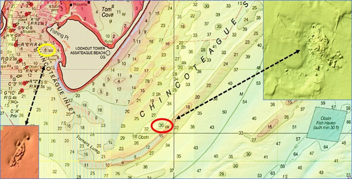
On the way out of Chincoteague Inlet towards the state reef, there is an old wreck on the north side (yellow circle and bottom left insert on Chart 1). The Coast Survey’s Automated Wreck and Obstruction Information System (AWOIS) records many bottom anomalies, and AWOIS records this wreck as unknown. Its presence was published in a 1978 Notice to Mariners by the Coast Guard. North of the inlet around the point in the red circle on Chart 1 lies the wreck of the P. J. Hooper which dates from 1950. No additional background about type or length of vessel is recorded but the BDV image shows scattered wreckage, which can be great for flounder fishing. The main mass is about 150’ long by 100’ wide.
The banks just outside the inlet were historically very productive, although commercial overfishing occurred during the 1970s and 1980s. About 5.5 miles offshore is the Blackfish Bank Reef, one of the artificial reefs in the Virginia reef program. This is one of the very early privately sponsored permitted reefs. The artificial reef along with the wrecks provide structure that increases biological carrying capacity and a physical deterrent to trawling.
An early history of Virginia artificial reefs was prepared in 1983 by Jon Lucy for the Virginia Institute of Marine Sciences at the College of William and Mary. His paper reports that citizens in Chincoteague and the local Coast Guard Auxiliary sponsored artificial reef development in 1968 and 1969. Another reference, discussed later, puts reef development even earlier. Perhaps the small fish havens are associated with that effort. Planned materials of opportunity included scrapped car bodies, tires, and obsolete barges. The Lucy paper reports that two menhaden vessels were sunk in the reef site in 1970. The context puts these wrecks at the Blackfish Bank Reef.
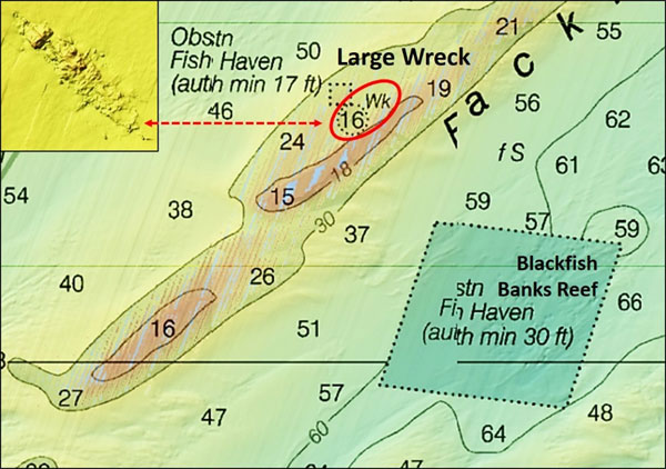
The little square fish haven is located on a bank northwest of Blackfish Bank Reef. Immediately southeast of the small fish haven and about 1200 yards northwest of the Blackfish Bank Reef’s northwest corner is a large wreck (red circle in Chart 2). AWOIS sheds little light about this wreck, recorded by the database in 1982. The debris field measures about 400’ long by 40’ wide. The wreck is mostly demolished except for a portion of its northwestern end where the only remaining section of the hull is visible. There is what appears to be a keelson or keel, suggesting that the hull section is upside down.
Turning now to Blackfish Bank Reef, it was permitted circa 1970. It is now administered by the Virginia Marine Resources Commission (VMRC). As with all VMRC reefs, there is a latitude and longitude grid drawing showing the recorded location of reef materials. Loran was used for the earliest placements. Many coordinates taken with Loran have not been verified with GPS, so there is some position error associated with the grid. VMRC also has a side-scan sonar report that was prepared in 2010 and is accessible on the Commission’s artificial reef website. The grid drawing shows, and the sonar report confirms, that there is a sunken vessel. North of the vessel is an unidentified object. With no other vessel-like objects showing in the BDV image, both of these reefs are probably the menhaden boats reported by the 1983 Lucy paper. Their location is shown in Graphic 1, which is an overlay of the grid onto the BDV sonar image. Coordinates for the southernmost wreck from the 2010 sonar report are 37’50.23945 x 75’15.39190. Approximate coordinates for the other probable vessel remains are 37’50.289 x 75’15.356.
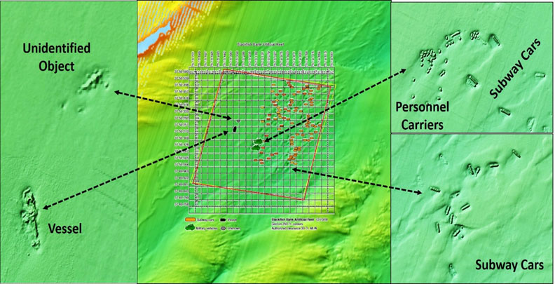
Additional deployments to Blackfish Bank Reef documented by the VMRC website include 40 armored personnel carriers in 1998, 50 New York City Redbird subway cars in 2003, and 100 stainless steel subway cars from New York City in 2008. The armored personnel carriers are located in the lower left middle of the site where the military vehicle icons are shown. Some fishing reports say three or four tanks were deployed. However, the VMRC data only record personnel carriers. Their composition is thick metal, making them more durable than the subway cars, which are scattered as patch reefs mostly in the northeast quadrant.
Review of the 2010 sonar report images suggest that some of the subway cars are caved in or missing sections. Although not conclusive, Redbird cars have shown rapid deterioration at other reef sites. Similar deterioration at this reef site would not be surprising. The stainless-steel cars, although with sides and tops made from thin sheets of metal, should fare somewhat better. Only the car boxes were deployed; there are no undercarriages or rolling stock. Physical condition issues notwithstanding, the subway car patch reef system is frequently mentioned as a go-to hotspot. Also reported is that the subway car reefs are hard on tackle, so expect to lose some rigs. Coordinates for all of the individual reefs keyed to a BDV graphic image are published in the Virginia Saltwater Sportfishing Association’s “Virginia Artificial Reef Guide.”
See Chinco-YES! Part II, continuing on to more wrecks and reef sites off the Chincoteague coast, including Winter Quarter Shoal, the David Atwater, and more.
-By Wayne Young As well as being a regular contributor to FishTalk, Wayne Young is the author of multiple books detailing wrecks and fishing reefs in the Chesapeake Bay, Delaware Bay, and beyond. All are available at Amazon.com, and you can find his Facebook page at Chesapeake Bay Fishing Reefs.