Our trip out of Chincoteague began with Part I: Blackfish Bank and nearby wrecks. Now, let's look at the famed Winter Quarter Shoal. It has a number of elements that go along with its reputation as an excellent hotspot for both fishers and divers. There are a few very small anomalies under the fish haven circle highlighted by the yellow circle in Chart 1. These are probably the remains of 60 junked auto bodies that were deposited at the fish haven in 1959. NOAA’s database also states that permission to dump material at the reef site was granted by the Baltimore District, U.S. Army Corps of Engineers, to the Coast Guard Auxiliary in Chincoteague. If the dates are correct, then this could be the oldest fish haven in Virginia waters.
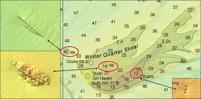
Other than the shoal itself, which is substantial, the primary artificial structure at Winter Quarter are two wrecks. The larger wreck is the barge Barnstable. It sank as the result of a marine casualty and was reported in a 1934 Notice to Mariners. The wreck is very deteriorated, but still has considerable mass spread out across the bottom which is great for attracting flounder and other species. The charted wreck southwest of the shoal is listed as unidentified. It’s about 150’ long and appears mostly buried. There are several objects under an obstruction circle on the east side of the shoal as well, as shown by the lower right Chart 2 inset.
One and a half miles southeast of the shoal lies the broken remains of the bulk cargo ship David Atwater, a U-Boat legacy wreck. The ship was loaded with a cargo of coal when it was attacked by gunfire during early morning hours in 1942 by U-552. U-Boats were brazen in their attacks during the early stage of the war. The sub fired 93 rounds from its deck gun, hitting the ship 50 times. The bulk carrier was set afire and sank with the loss of 24 men. Although the hulk is demolished, there is still a substantial mass on the bottom that provides marine habitat.
Working southeast from Winter Quarter Shoal, there are some very prominent wrecks that are popular diving sites and frequently appear in fishing reports. Wreck locations, circled in red, are shown on Chart 2. Coordinates are published by various websites. However, each is under an obstruction circle as are most of the other wrecks discussed previously. Just steer for the circle on your chartplotter, or pick out the circle coordinates on an electronic chart and enter them as waypoints.
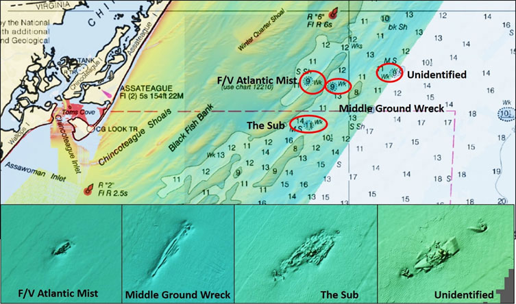
The fishing vessel Atlantic Mist has a steel hull and is 75’ long. It was recorded in 1982. The hulk locally known as the “Middle Ground Wreck” is what’s left of an unidentified wooden sailing vessel. It was recorded in 1984 and at the time, the vessel was partly intact and the bow rose 10’ to 15’ above the bottom. The BDV image shows the remains in a scour hole and suggests that the vessel is largely covered with sediment. The unidentified wreck known locally as “The Sub” is broken up and distributed on the bottom. The records have no information about the additional unidentified wreck shown on the chart. As displayed by the Bathymetric Data Viewer (BVD) image, the wreck is broken up into three sections, the center section being the largest. However, it appears to be quite substantial and using the BDV embedded distance scale, the main body of the wreck is about 200’ long.
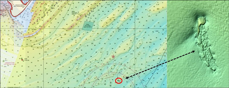
Next is the “Bone Wreck,” sometimes referred to as the USS Bone, but there never was a Navy ship with this name. The wreck is actually an unidentified vessel with a metal hull. A NOAA diver inspection circa 1981 was unable to determine the name on the hull due to extensive coral growth. The inspection found a 70’ scour hole on the east side. However, conditions have changed substantially over the past four decades. When the BDV image was taken, probably in the last 10 to 15 years, the hull was largely broken up. This is a popular dive site, and there are diver videos of it on the internet.
There are more wrecks further offshore that are outside of BDV side-scan sonar-like coverage. One is the 605’ long Marine Electric which sank in the location shown on Chart 3. This ship was a World War II tanker that had been converted to a bulk carrier with pilothouse aft. The ship was loaded with coal when it was caught in a storm and broke apart due to structural issues. There are two main sections and scattered debris. The wreck is a popular dive site, and there are diver videos on the internet — it holds a lot of fish.
Armed with all of this information and current fishing reports, haul on over and launch the boat. We’re on our way to some exciting fishing opportunities off the coast of Chincoteague!
- By Wayne Young. As well as being a regular contributor to FishTalk, Wayne Young is the author of multiple books detailing wrecks and fishing reefs in the Chesapeake Bay, Delaware Bay, and beyond. All are available at Amazon.com, and you can find his Facebook page at “Chesapeake Bay Fishing Reefs.