Whether you’re on the hunt for striped bass, sea trout, croaker, bluefish, Spanish mackerel, or flounder, there’s one place in the middle Chesapeake that’s a good bet for all of the above: Eastern Bay. Thanks to some rather dramatic underwater structure in varying depths, relatively strong currents, and water that tends to be both cleaner and saltier than it is just a few miles to the west, Eastern Bay is a prime destination for hordes of anglers throughout the season. Fishing it effectively, however, requires knowing the lay of the land.
South at the Mouth

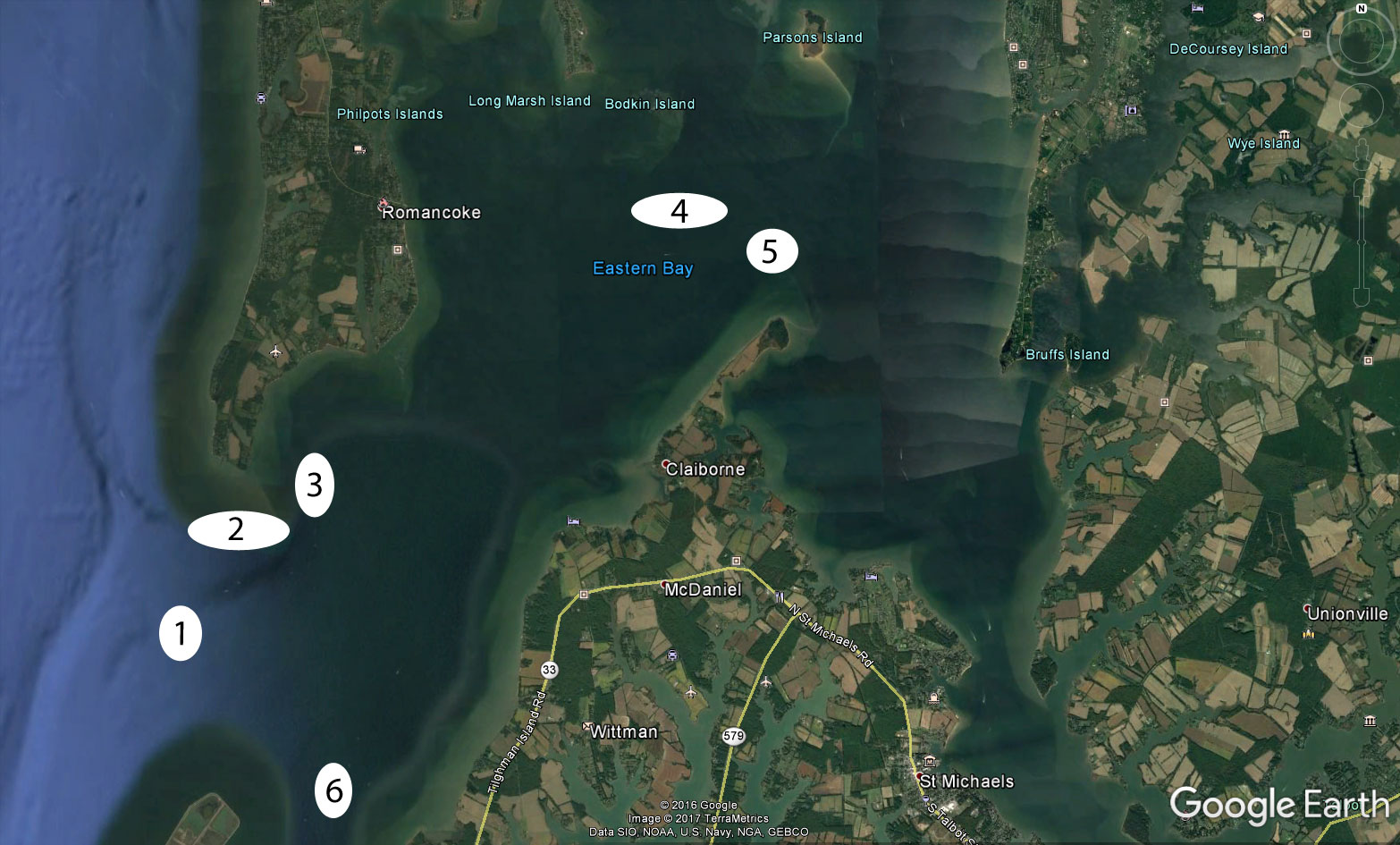
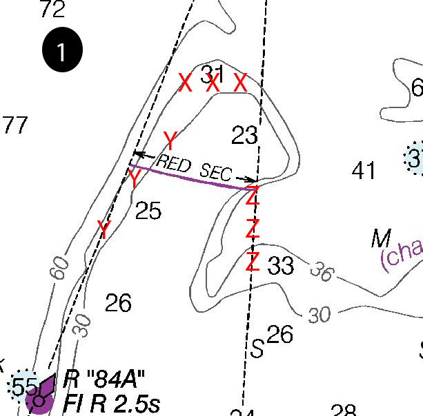
The mouth of Eastern Bay is defined by Poplar Island to the south, and Bloody Point to the north. (Note: here's an article and diagram addressing how to fish Poplar Island in specific.) The most prominent—and well-known—feature between these two points is The Hill, marked with the number one on the Google Earth image and blow-up chart. This spot was made famous during the 90’s and early 2000’s for its reliable chumming. That bite petered out close to a decade ago, but has been fairly good about three out of every five years since. While it doesn’t command the attention it once did, this always a spot worth checking out.

The X’s mark the northern edge of The Hill, where there’s an excellent drop-off from 25 to 35 feet and beyond. Most of the time, however, that 10 foot depth range is where chumming is best. One exception: when The Hill is crowded with chummers and there’s an outgoing tide, the edge marked Y is a good bet. Not only is the drop-off a natural fish-attractant, on the outgoing tide you can also benefit from everyone else’s chum as it heads south down the Bay.
The Z’s indicate another excellent drop-off, one which used to hold weakfish (back in the good old days of weakfish!) but in more recent years has held schoolie stripers and late in the fall, jumbo white perch. Both are usually best targeted by jigging, although just inshore of this deep water in the 22 to 25 foot zone, live-liners often find a good bite.
All of these areas should also be on your radar if you like trolling, be it for stripers, bluefish, or Spanish mackerel. Many boats establish a circular pattern that takes them across all three of these hot zones, and from mid-summer on, this is often a good bet. Keep your eyes out for birds here, too, as this entire area is often good for locating breaking fish.
The area marked by number two, just north of The Hill, is a sheer drop-off that goes from 10 to 12 feet clear down into 60 and 70 foot deep waters. You never know when you’ll find a school of suspended stripers marauding along this drop-off, so always keep a sharp eye on the meter when you pass through this zone. This edge is of more interest to flounder anglers, though. When flat-fish come up the bay they’ll be looking for drop-offs like this one, which are more or less underwater cliffs. Try bouncing four-inch GULP Jerk Shad or dragging Fluke Killers baited with bull minnow, from about 12 to 30 foot depths here. Added bonus: thanks to a few zillion crab pots placed above this drop-off, it’s very easy to see your speed and direction of drift when working this edge. For captions who don’t necessarily have drift fishing boat-positioning down pat, these visual indicators make this is a great place to learn how to get a feel for it.
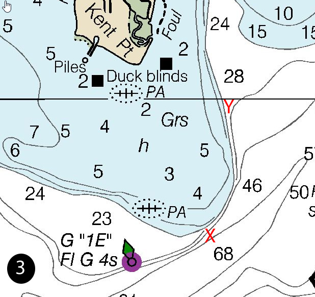
Just inside the mouth of Eastern Bay at the spot marked by number three, there’s another edge with an excellent drop-off. The green #1E marker is a useful reference point, but the drop-off is a lot better a half-mile or so to the north-east, where it goes from five feet to 45 in the blink of an eye as you move from west to east (marked by the X on the spot number three blow-up below). This is another spot that once upon a time held good numbers of weakfish. More recently, it’s been good for jigging up stripers and casting or trolling to Spanish mackerel later in the summer. The important thing to note here is that there’s also a drop-off with more of a north-south orientation (marked by the Y). It’s not nearly as extreme, but it does cause some interesting currents during an outgoing tide—and that’s when you’ll want to do your hunting here. At different times during different seasons, all the species we’ve mentioned thus far can be found in this area.

Eastern’s Interior
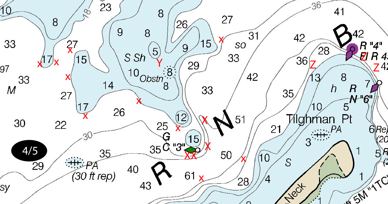
The fourth area we need to look at in detail is the collection of edges, drops, and humps marked with X’s near the green #3 can. These all hold fish at different times, and are worth probing for jiggers armed with soft plastics. Last season the ones to the north-west of the can were particularly productive. The fish do move around quite a bit between these different edges, so savvy anglers will stay on the move here—after a few casts with no results, be quick to move on.

That’s not quite as true of fish you might find at the drop-off marked by the can, and the edge to its south-east (also marked with x’s). This is another historic weakfish spot, but with a surprise—last year, there were actually some weakfish caught here! The numbers weren’t incredible and the sizes were unimpressive, but merely the fact that a few popped up in this area is encouraging. Bottom fishermen should also take note of these areas, which can offer croaker, spot, and the like many seasons.
There’s also one spot marked Y here, in the middle of the shallows. There’s some good structure in this area and at daybreak and dusk, this can be a productive area to cast jigs, shallow-diving crankbaits, and topwater. You’ll also find some larger fish here, with some over 30 inches making a showing in this zone last September.
Area 5, marked by the Z’s near the red #4 buoy on this same chart blow-up, is perhaps one of the very best flounder fishing areas in the middle Chesapeake. The edges and drops off Tilghman Point hold flounder more consistently than just about anywhere else in the vicinity, and the orientation of the point means you can usually find a good bite on one side or the other. During an incoming tide, expect the west side to produce the best catch. On an outgoing, the eastern side of the point is commonly more productive. Expect most of the strikes to come in the 12 to 24 foot range, with the fish moving shallower during the flood and deeper during the ebb. There’s one down-side to fishing here: during summer weekends a ton of cruisers wrap around that red marker on their way in and out of St. Michaels, so it’s almost never calm. Added bummer: since they the vast majority of them make a hard turn immediately after clearing the red marker, you often get hit by their wakes twice.
Finally we get to area six—but before we talk about this one, we should note that the entire edge between five and six should always be eyeballed for working birds and/or clusters of boats. This zone quite regularly holds fish and sees plenty of working birds throughout the season, though they could pop up just about anywhere. Make it all the way down to six, however, and you have some fairly mellow contours with drops from 10 feet down into the mid-20’s. The shallows to the west are the northern Poplar Island flats, to the east they run all the way to shore, and as you move south past the red #8 nun buoy, you enter the shallower waters of the Poplar Island narrows.
This pocket of deeper water does hold stripers, though often sub-legal, and some years you’ll catch flounder here too. But what this area is really best for is bottom fishing. A bottom rig baited with bloodworms will usually produce some bites here, and quite often this is the area you’ll want to visit to get your spot prior to live-lining.
For many middle Bay anglers, Eastern Bay is a staple. Virtually every season it produces, and quite often it produces better than just about any other area within cruising distance. So keep it in mind as the 2017 season develops—and keep these six areas tucked away in your head, as you consider the lay of the land.
By Lenny Rudow
Sign up here to get the weekly FishTalk Chesapeake Bay and Mid-Atlantic fishing reports in your email inbox, every Friday by noon.