Looking to learn where and how to fish a tidal river gorge that's chock-full of catfish, largemouth bass, and other species of interest? Georgetown Channel provides that opportunity right in the heart of our nation’s capital. Available for bringing in fish and honing your skills are deep water, strong currents, rugged bottom, and bridge piers that attract monster catfish, and nearby, shallow water bass habitat.

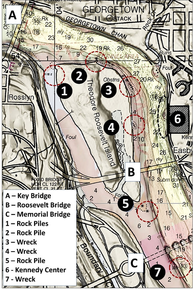
Location A marks the Key Bridge complex. Try fishing the foundation ruins of Aqueduct Bridge piers on the upriver side as well as the Key Bridge piers. Georgetown Channel downstream to beyond Memorial Bridge has very rugged bottom which is swept by very strong ebbtide currents; tidal scours near bridge pilings are always a good area to look for catfish.
The channel on the west side of what is today known as Theodore Roosevelt Island is an urban fishing jewel that provides sheltered kayak and canoe water, and the northern half is a good bass fishing destination. We learn from Frederick Tilip’s This Was Potomac River (1978) that Anacostine Island (subsequently Analostan Island) derived its name from an Indian tribe that once lived in Anacostia and moved for a time to the island in the 1660s. George Mason acquired it during colonial times for farming and hunting and renamed it Mason’s Island. It became Theodore Roosevelt Island after acquisition by the Theodore Roosevelt Memorial Association in 1931 and was subsequently donated to the Federal Government. An ice jam and freshet (snowmelt) combined in 1784 to hydraulically scour out the western channel to depths of up to 30 feet. This enabled ocean-going sailing vessels to use what was then termed “Little River” for access to the Georgetown wharves. The island was later connected to the Virginia shoreline at its northwest corner by a causeway which closed it to navigation.
Closing off the channel prevented current from flowing through it. The lack of physical energy resulted in severe shoaling of the southern entrance to the channel and contributed to sedimentation at the southern end of the island. The causeway across the north end is still there at Site 1. Look for submerged and uncovered rock piles a third to halfway out from the island immediately north of the sunken causeway remnants. The ruins line up with a dirt path that comes down to the shoreline on the island. The middle of this feature favoring the island side has been gouged out. The majority of the hard material is strewn in a line about 200’ long on the north side including two large rockpiles. A similar feature with a rockpile extends about 100’ down-channel on the south side. Most of the rocks are on the upriver side. This suggests that the causeway was breached and material was pulled off using mechanical equipment, reopening the channel to current flow. There are only a few feet of water over the causeway ruins in spots at low tide. It’s a substantial feature that provides excellent structural habitat when fish move shallow, but approach carefully.
Look for two wrecks south of the Roosevelt Island rockpile along the extreme western edge of the main river channel. Site 3 was charted before 1969 off the northeast corner of Roosevelt Island shoreline at coordinates 38'53.8873 x 77'03.5879. The wreck was reported at the six-foot contour line and isn’t visible on aerial or satellite images. It’s still there, broken up and mostly buried, but there’s enough structure to attract catfish and bass.

A wooden wreck located directly across from the south end of the Kennedy Center (site 4, Image 1, top right insert) was also charted at coordinate s 38'53.722 x 77'03.582. The wreck is submerged except at extreme low water conditions. It’s about 60’ to 75’ long and 10’ to 15’ wide. It’s referred to as a canal boat, and it could be. However, it has more of a schooner shape than a stubby canal boat hull profile. Whatever it was, the wreck has deteriorated considerably. There’s a lot of tree debris from the wreck downstream to the Theodore Roosevelt Bridge.
The Theodore Roosevelt Bridge piers provide solid vertical structure suitable for striped bass, bass, and catfish fishing. Imaging shows heavy scour around the base of the two center piers. The eastern pier borders rugged hard bottom which is swept clear of most sediment by the currents. Wooden fendering is weathered and worn. There are snags on the bottom so bring extra gear, but snags attract fish so try here for catfish.
Another feature of interest, a rock pile which uncovers at low tide, is off the southern end of Roosevelt Island at Site 5. When covered, the rock pile is known to attract bass and is definitely worth a few test casts.
Moving over to the east side, the sheer wall below the Kennedy Center (Site 6) has extremely rugged bottom that runs south along the east side past Memorial Bridge. The bottom consists of natural rock, the exposed tops of which are swept clear of sediment by strong ebb currents. Check this spot for catfish, and in warm weather, for bass.
Spot-Lock Vs. Anchor
I’ve fished these waters using either Spot-Lock or an anchor. If my fishing plan includes anchoring on hard or rocky bottoms for more than an hour or so, I’ll bring a grappling anchor with a weighted shank and heavy aluminum prongs that bend in case it snags. I also bend on a light “preventer” line to a ring on the bottom of the hook so that it can be pulled out backwards if necessary. However, this ancient mariner much prefers the convenience of Spot-Lock for holding position and avoiding the manual effort required to haul in an anchor.
Best Catfish Bait
As for catfish bait, I get good quality chicken livers from a local food market. They go on a 6/0 to 8/0 circle hook rigged on a 30-pound test leader below a slider with one to as many ounces as needed to hold bottom. I use a quick release clip and slider so that I can quickly replace rigs lost to snags. See “How to Catch Blue Catfish on the Potomac: Blue Thunder” for more details on rigging and baits.
- By Wayne Young
As well as being a regular contributor to FishTalk, Wayne Young is the author of multiple books detailing wrecks and fishing reefs in the Chesapeake Bay, Delaware Bay, and beyond. All are available at Amazon.com, and you can find his Facebook page at “Chesapeake Bay Fishing Reefs.”