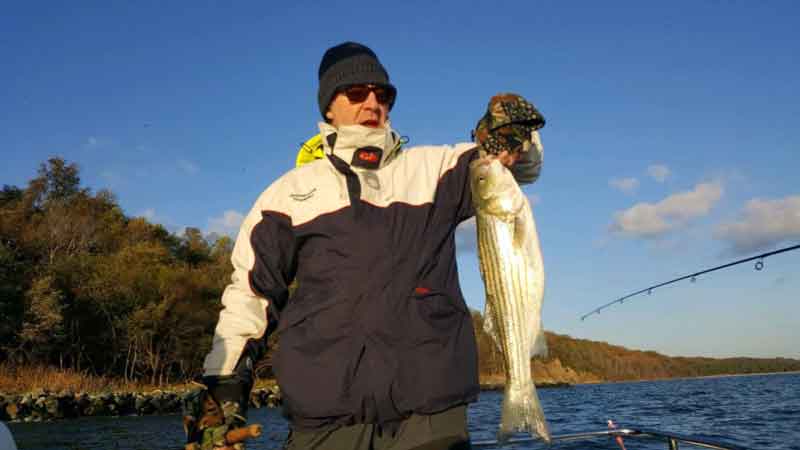
Casting to or jigging shoreline structure and fishing light tackle for stripers in the shallows is often, in a way, fishing history. Every structure has a story, sometimes known, sometimes not so well known, sometimes forgotten. Much of this structure is intended: docks, bridges, platforms, breakwaters, shoreline protection, pipelines, discharge outlets, lighthouses, and artificial reefs. But there’s also a lot of unintentional structure: wrecks, obstructions, and ruins. Indeed, awash or submerged riprap, compromised shoreline structures, and ruins are part of the Bay’s seascape. They demonstrate where changed conditions turned land into water — and into fishing destinations.
How these features relate to environmental conditions, currents, and migration and predator feeding patterns provides insight into their fishing potential. However, a note of warning: there are many submerged uncharted obstructions along the Bay’s shorelines including broken off pilings, rock piles, wrecks, and ruins. So it’s best not to run too close to shorelines unless you know for sure what is there.
Shoreline Retreat
Sea-level rise is a contributing factor to shoreline retreat. There’s also a subsidence factor, such as occurs in some locations where deep ground water is extracted. Then there is the pounding of the shoreline by storm-generated waves. No need to get wound up about the causes or responses to sea-level rise — the focus here is becoming aware of and taking advantage of changed conditions that alter or create fishing spots.
As sea level rises and the land or marsh behind rock protection erodes, backside rocks lose underlying support, collapse, and may become awash or drowned. Structures behind failed sections become isolated, undermined, or damaged as the shoreline retreats, and eventually become ruins. If on an island the island itself may disappear, leaving behind a shoal (as is the case with Sharps Island, Long Marsh Island in Eastern Bay, Little Watts Island below Tangier Island, etc.).
Structure of this type is often uncharted. Indeed, there are a number of prominent uncharted rockpiles that are fished by those in the know throughout the Bay waters. Although some of this structure is visible from satellite aerial images, much is not. Or it may appear as shadows that are difficult to discern. One of the longest well-known submerged shoreline protection structures that’s visible in aerials is found in the Choptank River, offshore of Todds Point. This is an excellent example of long-lost shoreline protection becoming structure for anglers. Satellite imagery shows a 1200-yard-long underwater shadow that becomes partially awash when waves roll over it. The structure runs irregularly north of the shoreline leading to Todds Point. The history is often obscure or lost for old man-made objects, and so it is for this structure. A house built at the point in 1860 was in ruins in 1975 according to the Lower Choptank River Cultural Resources Inventory (2002). An internet search found nothing else.
The shadow is well south of the shoreline shown west of “Tod’s Point” by an 1862 Coast Survey chart (available in digital format on-line from the Library of Congress). So, the structure was probably constructed after the Civil War. Considering the date of the house ruins and land loss between then and now, the underwater structure perhaps dates from the late 1800s or early 1900s. The main structure is oriented approximately southwest to northeast. Along the northeastern third of the primary structure, numerous short, wide shadows on the Bay side protrude at right angles. A second shadow on the southeast side of the northeast end is where the1862 shoreline curved toward the southeast. Thus, the northeast end appears to have been a groin. Charted rocks are northwest of the southwestern end and well offshore. The 1862 shoreline approached these offshore rocks. Several objects appear there in an aerial photograph which also shows several rounded shadows immediately to the south. Their appearance suggests submerged shoreline protection structures around retreating points.
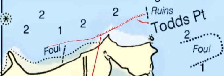
The Todds Point elongated submerged protective structure obviously fell into disrepair and was eventually compromised. The shoreline behind it thereafter eroded to its present location, now protected by substantial riprap. The entire submerged structure offers excellent light-tackle casting for striped bass and in the past speckled trout, as well. Just be very careful when approaching and operating in the area.
Looking around the Bay, there are many other spots where similar conditions have produced similar results. Down at Smith Island, a protective structure runs across the entrance to Goose Harbor Cove. A mostly submerged rock breakwater starts off Chaisey Point at a stake immediately south of the Big Thorofare south rock breakwater, and runs southeasterly from there. A very visible, large, interesting ruin is on the east side of Oyster Cove at Taylors Island. The dropped steel tower at Adam Island provides yet another example of eroded shoreline become fishing structure. Perhaps the most famous failed riprap shoreline protection is at Cedar Point. Originally, the lighthouse was on a point. There was a pond between the light and the current shoreline with a narrow strip of land on each side. The rocks that are around the current navigation light are riprap that protected the point. When the strips of land breached a wooden bulkhead and a dock were constructed, hence the broken off pilings that are between the rock piles.
Shoreline Timber
Just as it does in a lake or river, submerged fallen timber and stumps provide cover for baitfish and lurking spots for predators to lie in ambush. Some spots are obvious and many are in very shallow water and difficult to fish, but others are farther offshore. Timber stands fell into the Bay as islands eroded and shorelines retreated. Old maps, especially topographic maps, and satellite and aerial images are very helpful for figuring out where stands of trees were in relation to where shorelines are today. For example, numerous spots around Eastern Bay shorelines and Parsons Island have fallen trees. There is also a massive submerged timber field to the west, northwest, and north of the northernmost James Island remnant (mostly gone now). It’s possible to get in there with care on the west side, but timber breaks the surface on the north side of the debris field. There’s also submerged timber in the east-side shallows. This is kayak water when weather and surface conditions are suitable.
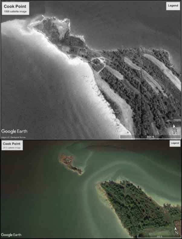
Along the west side of Cook Point in the Choptank River, a substantial number of downed trees along the shoreline are visible in aerials. The location offers another prime example of the effects of erosion over time, demonstrated by the transition of Cook Point from a peninsula to an island over a 15-year time span. The ends of the island remnant and the north end of the point would be good places to check for stripers when the ebb current is running strong, and speckled trout show up there, too. Two miles north is the Cook Point Oyster Sanctuary where hundreds of Reef Balls support oyster restoration. (This is a great project to support in addition to a great spot to fish — visit the Coastal Conservation Association Maryland for details). A failed concrete bulkhead 1200 yards south of the existing peninsula at the north end of Trippe Bay extends well offshore. The groin at the south end is charted, but the rest of the structure isn’t. A widely scattered band of submerged trees oriented east-west is on the Bay side of the structure.
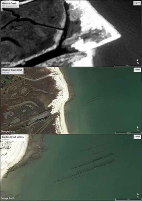
Physical forces interact with the shoreline south of Gwynn Island in the same manner as if it were an ocean shorefront. Relentless Bay waves and periodic storm waves pounding the south end of Gwynn Island, island remnants to the south, and the shoreline, have caused dramatic changes. One, the closure of a man-made inlet from Garden Creek to the Bay, resulted in unintentional fishing structure. Four charted wooden jetties were constructed during the mid-1930s to intercept sand drifting southward along the shore and to create a shorter entry to Garden Creek. The two large southernmost jetties were the sides of the inlet opening which was excavated through the shoreline. A shorter but uncharted fifth jetty is on the southwestern side. Although barely open in 1975, it was sanded in by 1994 as was the natural inlet to the north. Sand continued to be carried westward onto the land by over-wash from storm waves, filling the channel leading to the natural inlet. The shoreline suffered major erosion during Tropical Storm Isabel, and the headland breached behind the jetties by 2005. Now, the east ends of all five jetties are as much as 500 feet offshore and are separated from the shoreline by about 250 feet. The two northern jetties are submerged. The pilings for the three southern jetties are exposed.
Shoreline structures may only hold a few fish, or it may hold a bunch. Hunting for them is part of the light tackle attraction, and helps keeps the fishing game both interesting and challenging. The preceding survey gives but a glimpse of what’s out there. Fishermen with a sense of exploration can “fly” the shoreline with satellite and aerial imagery applications and take a look. Just remember, there are a lot of nasty things to run into — enjoy the fishing, but be safe.
- By Wayne Young, author of “Bridges Under Troubled Waters: Upper Chesapeake and Tidal Potomac Fishing Reefs,” and "Chesapeake Bay Fishing Reefs: Voyages of Rediscovery," at Amazon.com. You can find his Facebook page at Chesapeake Bay Fishing Reefs.
Sign up here to get the weekly FishTalk Chesapeake Bay and Mid-Atlantic fishing reports in your email inbox, every Friday by noon.