Fishing reefs attract a lot of attention, but natural features abound in the Chesapeake Bay. The Susquehanna’s riverbeds snaked their way around many ridges as they cut their way through the coastal plain and were channeled by the progressive formation of the lower DelMarVa peninsula. We’re using the plural here because geologically there were four outlets that formed as the peninsula migrated southward. The now-submerged former riverbed edges, ancient ridgelines, and headlands became shoals. Colonized by oysters, accented by outcroppings, and peppered with geological formations containing sand, gravel, and rocks, these became today’s fishing hotspots.
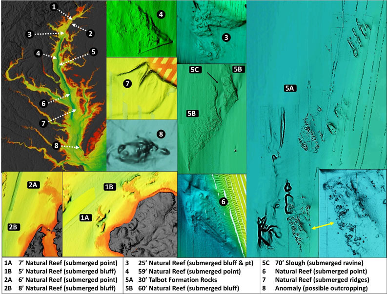
Look along the eastern side of the Upper Bay shoreline for a series of submerged bluffs, points, and hard outcroppings which may be peaks of now submerged hills covered with sediment. Four are shown as inserts on Image 1 at Sites 1 and 2. The hard natural reef directly off Worton Point (Site 1A) is well known for upwelling that provides foraging conditions for striped bass. But don’t neglect the submerged point just to the north at Plum Point at Site 1B, the “real” Plum Point of long ago. This is an example of where the original point was drowned from the combined effects of erosion and water level rise and where the charted shoreline doesn’t give away the substantial underwater structure. The attribute of interest is the obstruction to current flow along the bottom, which causes turbulence and creates predator foraging conditions.
Also check out the submerged point and bluff to the south at Sites 2A and 2B. Site 2A is a drowned point that projects out from the shoreline at Stoops Point perpendicular to the Upper Bay’s main stem. It extends out to the edge of deeper water. The orientation obstructs both flood and ebb currents along the shoreline causing subsurface turbulence. A smaller submerged bluff, now a shelf, is just to the south at Site 2B.
An uncharted hard outcropping at Site 3 is the Swan Point from eons past. It protrudes out into the bend of the ancient Susquehanna riverbed where it ran along the eastern edge of the ancient geologic peninsula to the confluence with the Chester River entrance. The reef is oriented north northwest to south southeast. It’s about 400 yards long and 125 yards wide. The northern half is most prominent with depths that slope north to south from about 25’ down to 45’. The southern half is less pronounced with depths from about 45’ to 55’. The orientation and configuration disrupt the current flow along the bottom, creating turbulence and favorable foraging conditions for striped bass.
Site 4 is an interesting uncharted natural feature in about 60' of water with well-defined sharp lines, indicating hard material. It correlates with an area shown by the now out-of-print Fishing in Maryland Annual as “Brownie’s Hill.” The rugged wedge-shaped feature juts into the ancient riverbed. It’s about 400 yards wide. The northern edge is about 500 yards long and the southern edge is about 200 yards long. The eastern point is at coordinates 38°43.020 x 76°28.680. It has the appearance of a submerged headland from a time when the river was a gorge in a valley. This prominent feature’s configuration should create subsurface turbulence when current is running. Having caught stripers while they were pushing baitfish onto this shelf, I certainly would be looking at my fishfinder when passing by.
Site 5A is the “Stone Rock” on the west side of Sharps Island Flats. Although there might be ballast stones there, the extensive fields of rocks are mostly naturally occurring gravel, stones and rocks that geologically are part of the Talbot Formation. These materials were distributed in pockets in portions of the formation and were most prominent along the west side of Sharps Island. As the island eroded away, the rocks settled into a surface layer on the bottom.
There are several unnatural rock piles on the flats as well. One is the now-submerged icebreaker rockpile from the second Sharps Island Light. It’s charted as a shoal at coordinates 38°37.971 x 76°22.402 and marked by a navigational aid. The U.S. Coast Pilot 3, Chapter 14, reports rocks that are sometimes awash at about coordinates 38°37.000 x 76°21.800, which corresponds with the last island remnant before it was drowned. I’ve never seen them awash, but that might occur when a strong northwest wind blows water out of the Bay. There are also remnant stones and perhaps masonry from the old hotel foundation nearby.
Southwest of the southwest side of Sharps at Site 5B is another uncharted natural formation. This feature has well-defined, sharp lines, indicating hard material that straddles the 60’ contour line. It too has the appearance of a submerged point from a time when the river was a gorge in a valley. It’s bisected by a submerged ravine (Site 5C) that’s now a slough with depths of about 70’.
Perhaps you heard the fishing report that “fish are at buoy 72.” But if you just fish right around the buoy, you’re only getting a small piece of the action. A huge submerged point protrudes out over 400 yards from the east side of the old Susquehanna riverbed. The western edge is over 600 yards southwest of the buoy. It obstructs and diverts incoming tidal current which flows north strongest along the bottom, producing subsurface turbulence and upwelling. It also interacts with ebb currents. Bull redfish and stripers could be anywhere across this large structure over what otherwise appears as, and is charted as, deep water. Plus, if the channel side of the buoy isn’t producing, try the extensive shelf to the east with high points and sloughs which are also foraged by these species. This wide area of diverse structure is marked in general as Site 6.
Proceeding south to the Tangier Island target area brings us what I refer to as the “Bay Bug.” It’s an uncharted, obscure, weird structural feature consisting of twin creepy crawler feelers jutting out from the southwest point of a shelf at Site 7. Look at coordinates 38°46.816 x 76°05.431, east southeast of the Northern Neck Fish Haven and 3400 yards southwest of the Tangier Targets prohibited area center point. The feature is outside the prohibited area, although inside the restricted zone. The Bug looks as if it’s a natural formation, something like two adjacent ridge lines. The feature may have a local name, but if so, it has eluded me so far. The narrow ridges are about 200 yards and 150 yards long respectively. They connect at near right angles to a broad underwater plateau at their northeastern end. The Bug could be the topographic highs of ridges on either side of an ancient creek valley. Surrounding bathymetric contours give no indication that a valley existed, although one could have filled in from sedimentation. Regardless, the ridgeline disrupts and channels subsurface current flow around the shelf and creates turbulence. Bait could potentially be concentrated by flood currents between or against the ridges and the shelf, so this is one of those out of the way spots that deserves a look when fishing the northern end of the Lower Bay.
About 600 yards bearing 162 degrees True from the Old Plantation Flats lighthouse ruins at coordinates 37°13.430 x 76°02.700, marked as Site 8, is another uncharted anomaly. The feature is about 60’ long and 15’ to 20’ wide. It’s oriented east-west and sitting in a scour hole with a least depth of about 11’. Vertical rise can’t be ascertained from the data, but the image suggests at least several feet. The BAG image suggests two pointy ends which could be indicative of a wreck. However, it could also be a natural outcropping or another rock pile. It’s worth checking it out, whatever is there.
Combinations of rocks and oyster reefs occur at multiple locations. Notable examples are the previously noted rocks from the Talbot Formation at Stone Rock, the shelf east to northeast of Point Lookout, and substantial outcroppings at the northwest corner of Nandua-Pungoteague Reef. Look for numerous rock outcroppings on the shelf around both sides of Point Lookout, but especially on the east side as shown by Image 2.
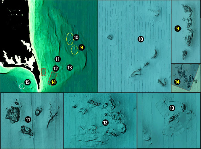
Site 9 is referred to locally as “Hotel Rock” and a small section is charted as an obstruction. But the formation is huge, extending well outside the charted shoal circle. Site 10 is listed on old charts as “Butler Rock” but isn’t charted on all modern electronic charts. Everything from stripers to flounder to sea bass will sometimes be found at these outcroppings.
The smaller red outlined box is the Point Lookout Fish Haven in front of the Point Lookout fishing pier. The bottom was conditioned with shell. The larger red box marked as Site 14 is an oyster sanctuary. A small spot near the center of the sanctuary has clusters of reef balls placed there to test their surface as cultch for oysters. By far the most notable feature is a huge uncharted natural reef at Site 14. Rocks on the west side of the point are less extensive and mostly uncharted. One rock cluster known as “Jobs Rock” is at coordinates 38°02.387 x 76°20.163. Drift here for flounder and prospect for stripers.
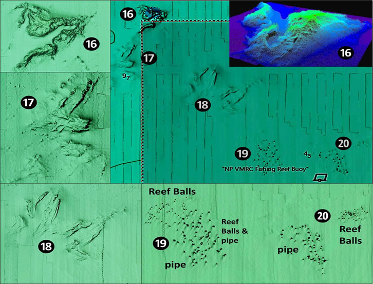
Another location with substantial natural outcroppings is adjacent to and inside the Nandua-Pungoteague Reef, a Virginia Marine Resources Commission artificial reef. Site 16 marks the largest of these features. It’s charted as an obstruction just outside the northwest corner of the fish haven. The overall formation extends well to the southwest to Site 17 and isn’t charted. Vertical relief is about three to five feet. There’s another large natural formation around Site 18 inside the fish haven. If the natural formations aren’t producing, try the artificial reef deposits in the northwest quadrant of the fish haven shown by Chart 1. The small objects are reef balls and the larger objects are concrete pipes (Sites 19 and 20). The BAG data layer shows that there is one area where the reef balls and concrete pipe overlap.
- By Wayne Young. As well as being a regular contributor to FishTalk, Wayne Young is the author of multiple books detailing wrecks and fishing reefs in the Chesapeake Bay, Delaware Bay, and beyond. All are available at Amazon.com, and you can find his Facebook page at “Chesapeake Bay Fishing Reefs.”