In early 2020, Wolf Trap Lighthouse was listed for sale (again). Want to own a lighthouse? Located off Horn Harbor, Wolf Trap Lighthouse is named for Wolf Trap Shoal. The shoal was named for H.M.S. Wolfe which grounded there, was refloated, and then became the subject of a dispute between watermen salvors and the ship’s captain. This dangerous shoal was first marked in 1821 by a lightship. It was eventually replaced by a screwpile lighthouse that was carried away by ice. A caisson “fire plug” style lighthouse was constructed on the shoal in 1894. The light was eventually automated and the structure sold to a private party. The lighthouse has changed hands several times, and today sits on its namesake shoal charted as abandoned, but that’s for navigational purposes. The lighthouse remains privately owned. The bottom around the lighthouse is reported as some of the best spadefish grounds in the area. But don’t forget the lighthouse itself (site one on the chart). Toss jigs, cast lures, or drop live baits alongside the heavily encrusted metal caisson which was the form for pouring the concrete base inside.
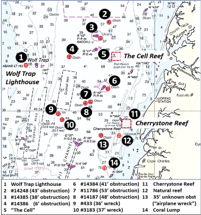
Working from north to south, at site two there is a 43-foot obstruction located in an area of rugged bottom. The feature is within “BAG” Color Shaded Relief coverage using the NOAA Bathymetric Data Viewer (BDV). Coverage of the immediate area is partial, but sufficient to show several anomalies that present as low-lying elongated mounds, one to the northwest and one to the southwest. Each bottom feature is over 100 yards in length and the surrounding bottom offers more promising fishing opportunities. A short run about 1.5 nautical miles to the southwest is Buoy R “42.” Several hundred yards to the southeast of the buoy there is a 38-foot obstruction, site three. This is a very small object laying in a broad area of rugged bottom to the east and southeast of the buoy.
Site four is another small obstruction about 2.5 miles southwest of R “42” and three miles west of The Cell. The obstruction consists of four visible pieces and a faint outline of who-knows-what on the bottom. The BDV distance scale suggests the feature is about 40 or 50 feet long and 15 to 20 feet wide. Although the feature is relatively small, the surrounding bottom appears relatively flat. Thus, the feature might attract a baitfish and predators and is worth checking out when passing by. Then head east to The Cell for some fine artificial reef structure, as well as the ruins of the former Navy degaussing station. The layout is presented in “Chesapeake Bay Fishing Reefs” (Young, 2020) and in Fishing at the Cell.
Moving south southeast to Buoy R “40,” at site six there is a 41-foot obstruction that is about 600 hundred yards to the southeast of the buoy. This feature is about 20 by 30 feet with a main object and two smaller anomalies. Although the obstruction is small, there is a scoured trench that runs from the object over 100 yards to the north. Southwest of R “40” about 1.5 miles is site seven and at 1.8 miles is site eight. Both are small and non-descript but you never know, they could hold fish at times. Further to the southwest lies another wreck, site nine, that was first recorded in 1984. The AWOIS record reports it is a “steel barge like structure, 48-feet long with 11 feet of beam; deck of western end is forced upward…”
Southeast and 3.9 miles from R “40” is site 10. Found during a wire drag in 1978, it’s described as a wood and steel wreck in three sections. The “BAG” Color Shaded Relief screenshot shows a north-south orientation with raised debris at the north end. Also shown is a faint gunnel-like outline starting at the southern end. The feature measures about 60 to 70 feet long and 20 to 25 feet wide.
When fishing the Bay off the Eastern Shore, concrete pipe and slab structures deployed in Cherrystone Reef (site 11) deserve serious attention. The reef layout and nearby natural and unnatural features are presented in “Chesapeake Bay Fishing Reefs: Voyages of Rediscovery” (Young, 2020) and in Cherrystone Reef and the Bandit. Among the natural reefs discussed in each is a huge hard reef at site 12. The rugged character of this formation isn’t effectively conveyed by bathymetric contour lines.
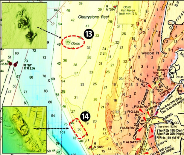
Southwest of Cherrystone Reef fish haven at site 13 is the so-called “Airplane Wreck.” How this name came about is unknown. The shape and configuration of the materials in three main piles have the appearance of deliberately placed or dumped materials. These concrete rubble piles are thus characterized by the author as a “bandit” reef, an unofficial and undocumented artificial reef. Site 14 is a large natural reef locally known as the “Coral Lump.” Both of these features offer substantial structure, were featured in a tautog seasonal movement field study by Jon Lucy and Michael Arendt in 2000, and are well worth checking out.
Although some of the features in the preceding discussion are small, most are worth trying when passing through the area — especially site nine, which has the most wreck structure for jigging. Or, plop down $250K for the old Wolf Trap lighthouse and fish out your bedroom window.
See our Chesapeake Bay Fishing Reefs Guide to get the lowdown on other mad-made wreck and reef hotspots in the Bay, plus a few in the ocean off the DelMarVa coast.
- Wayne Young is the author of “Bridges Under Troubled Waters: Upper Chesapeake and Tidal Potomac Fishing Reefs,” and “Chesapeake Bay Fishing Reefs, Voyage of Rediscovery.” Both are available at Amazon, and you can find his Facebook page at Chesapeake Bay Fishing Reefs. Look for his new books, “Phantoms of the Lower Bay” and "Hook, Line, and Slinker."
Sign up here to get the weekly FishTalk Chesapeake Bay and Mid-Atlantic fishing reports in your email inbox, every Friday by noon.