Draining the Chesapeake Bay would reveal now-submerged structural features surrounding islands, drowned islands, and remnants of eroded shorelines including fallen timber, rocks, and ruins. These provide some of today’s marine habitat and fishing hotspots for shallow water species like striped bass and speckled trout. We can drain the Bay electronically, in a manner of speaking, using the Digital Elevation Models (DEM) Color Shaded Relief data layer in the Bathymetric Data Viewer (BDV), the online application that enables users to view three-dimensional-like bathymetry.
Island and shoreline composition varies. Where there is marsh, erosion is slow because the consolidated sediment and root systems are more resistant to wave action than unconsolidated lands and soils. For example, Holland Island once hosted a thriving watermen’s community with large frame houses, a church, a school, a post office, and a baseball field. Most structures stood on a modest ridge on the west side. When a sod bank along the western shoreline eroded away the sediment banks behind it quickly succumbed, and the community was doomed. All but one of the houses were dismantled, moved, and rebuilt on the Eastern Shore mainland. All that’s left are submerged ruins. Further up the Bay Sharps Island disappeared below the waves, leaving natural rock deposits, ruins including the abandoned Sharps Island Lighthouse, and a now submerged icebreaker rockpile. This dynamic process of erosion and shoreline retreat is occurring throughout the entire Bay.
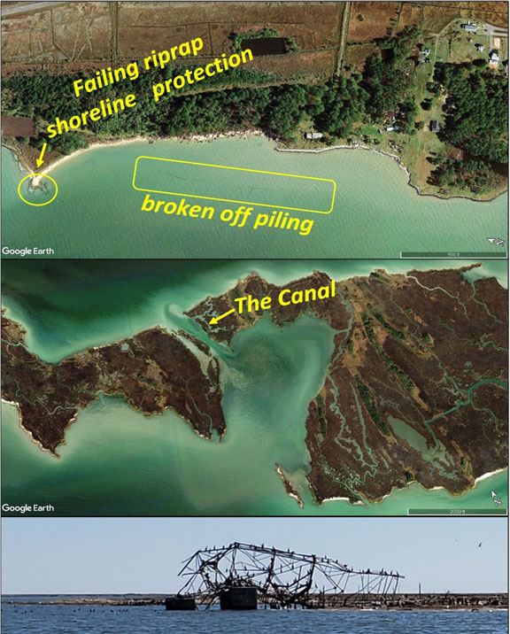
As water levels rise and shorelines erode, features formerly on land are now at the water’s edge or submerging, such as the fallen observation tower at Adam Island (Image 1 bottom picture). Features we fish have “moved offshore” as the land retreated (Image 1 top insert), and landmarks we used as visual references to find them disappeared. While these changes are bad news for some, they also provide new light-tackle fishing opportunities. Keeping up with these changes to stay current with a system that’s in constant flux takes time and effort.
Hotspots to look for often involve exposed points, creek openings, failed shore protection structures, and in some locations, fallen trees and stumps. Once while fishing with “Walleye Pete” Dahlberg, after he carefully approached the marsh edge we drifted through some stumps. Clunk! The outboard skeg had hung up on a submerged stump. Fortunately, raising the motor freed the snag with no damage to the prop. Don’t be surprised to find stumps, fallen timber, and ruins hundreds of yards offshore. Well off Bloodsworth Island, for example, there are submerged tanks that were once targets sitting on dry land. So, it’s best to not run through near-shore areas at high speed.
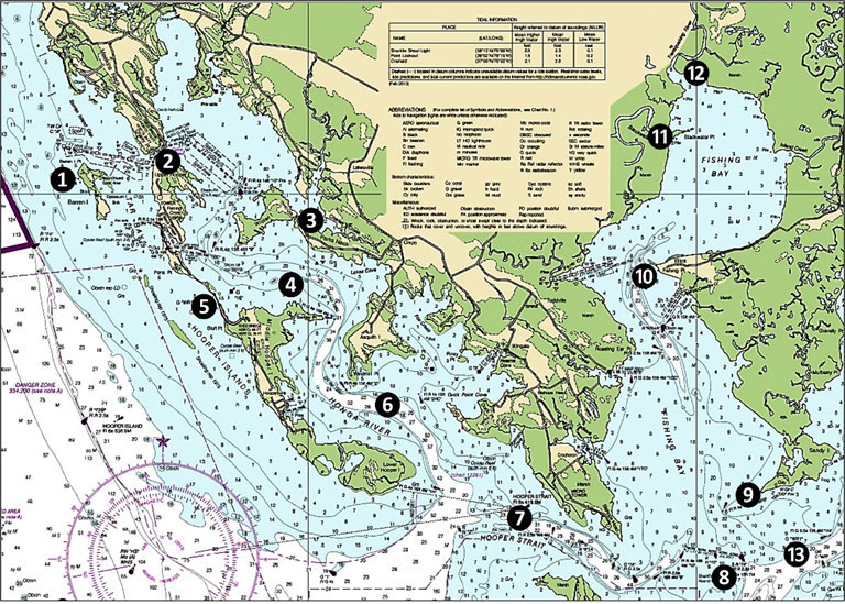
Various spots in and around the Honga River, Hooper Strait, Upper Tangier Sound, and Fishing Bay produce when conditions are favorable. Site 1 on Chart 1 is Barren Island. The east side has numerous shoals to avoid. The channel north of the island is narrow and shallow, but usually has sufficient depth for a careful transit by an outboard boat. Normally we would suggest casting to the various shoreline protection structures on the Bay side, but the island is the location for a restoration project and conditions are changing. Rock armor protecting a future dike system will add structural habitat and although project construction will make the site unavailable for a while, keep this spot on your list to check out in the future.
Site 2 is the well-known channel and bridge over Fishing Creek to Upper Hooper Island. Cast and jig here for stripers. Site 3 is “The Canal” at the eastern tip of Wroten Island (Image 2 middle insert), another well-known spot. At various times it holds rockfish, speckled trout, croaker, perch, and flounder. Site 4 is an old wreck. Reported in 1929, it’s recorded as an unknown two-masted schooner. Site 5 marks the bridge between Upper and Middle Hooper Island. There’s good depth in the channel under the bridge. There’s extensive shoal water west of the bridge, and local knowledge is important when approaching from the Bay side. There’s much better water depth on the east side. However, working down the west side of Middle Hooper Island, there are segmented breakwaters at the southeast end of the bridge causeway and multiple spots where there are failed shoreline protection structures.
Site 6 is a general marker for the Honga River. Look for creek openings, points, and islet remnants. Conditions are often difficult even on good days due to strong tidal currents. Look for light structures, rocks, and ruins from Hooper Strait to the entrances to Fishing Bay and the Wicomico Rivers. Site 7 marks Hooper Strait Light, a skeletal steel tower, and importantly, a beaten down, submerged icebreaker rockpile just northwest of the light tower. This one isn’t specifically charted, but it sometimes goes hot with stripers so don’t pass it by.
Site 8 marks the former Sharkfin Shoal Lighthouse where a skeletal steel platform light replaced the screwpile lighthouse. Historic photos show a large icebreaker rock pile that rose well above the surface. A NOAA investigative survey in 2014 confirmed that the rocks are submerged, but they are there (see Chart 2 insert for the approximate location).
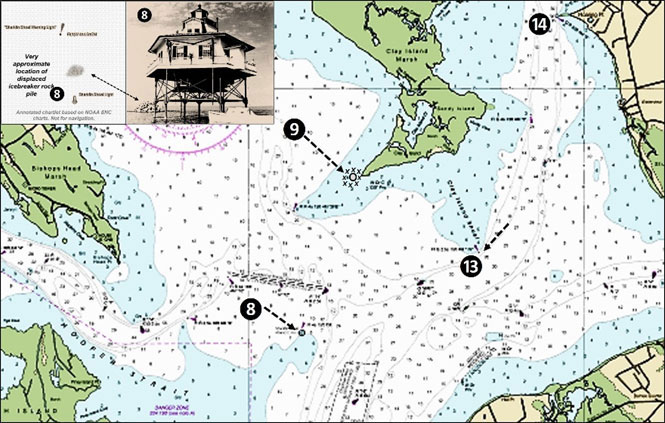
Site 9 marks prospective submerged ruins of Clay Island Lighthouse at coordinates 38°13.991 x 75°58.317, immediately southwest of Phillips Point. There’s an underwater spit with as much as a 30’ drop-off at Fishing Bay Entrance Light “2FB.” Up inside Fishing Bay, the most prominent features are the remnant deepwater channel with its steep edges and the underwater spit that runs out from Fishing Point, both marked in general as Site 10. Sites 11 and 12 mark the Blackwater River and Transquaking River, respectively.
There’s a wreck at Site 13 marked by Clay Island Shoal Lighted Wreck Buoy “WR1.” Although no other details are recorded, the fact that it’s charted and marked by a warning buoy means something substantial is there. The Nanticoke River also has a deepwater channel that runs well upriver with steep sides. Look for an underwater spit that juts out from Roaring Point (Site 14) just up the Nanticoke River. Also check the rock breakwater ends at Nanticoke Harbor Boat Ramp, Dunn Creek below Bivalve, and Bivalve Harbor.
Site 15 marks Great Shoals Light at the entrance to the Wicomico River. The RNC chart symbol is for a light with riprap protection. Although rock placement isn’t mentioned in the construction and maintenance history for the former screwpile lighthouse and none is definitively shown in photos, the symbol indicates that some are under (or in the immediate vicinity of) the skeletal steel tower. A marginal quality U.S. Geological Survey satellite image taken in 2007 and found in Google Earth historic images shows objects which present as subsurface rocks. The shadow is about 75 to 100 feet east of the tower and resembles how subsurface rocks appear at other locations.
The barge (Site 17) on the southern side of Bloodsworth sometimes holds stripers. The offshore end is at coordinates 38°08.785 x 76°03.143. Check out satellite images to see where it lies in relation to the wreck symbol. Just to the south at the middle islet off the north end of rapidly eroding Adam Island (Site 18), a laid over steel tower used to be on firm ground (bottom insert, Image 2). It’s now at the water’s edge waiting to become an unintentional artificial reef. Remnants of an old corduroy (log) road and other debris are submerged northwest of the tower.
Site 19 marks Holland Island, discussed earlier. South of the island at Site 20 is Holland Island Bar Light where another submerged, beaten down rock icebreaker is located. Site 21 is a general marker for South Marsh Island. Although there are features further south, we’re going to close this discussion with the iron caisson “sparkplug” light structure, Solomons Lump Light, at Site 22. It’s always worth a few casts when passing through the area.
-By Wayne Young. As well as being a regular contributor to FishTalk, Wayne Young is the author of multiple books detailing wrecks and fishing reefs in the Chesapeake Bay, Delaware Bay, and beyond. All are available at Amazon.com, and you can find his Facebook page at Chesapeake Bay Fishing Reefs.