Wrecks and structure that we might routinely pass over in the Patuxent River enroute to the Chesapeake ruins are seldom fished. But when conditions on the Bay main stem are too rough for small recreational craft, they provide prospecting alternatives that might produce bottom fish, stripers, and more.

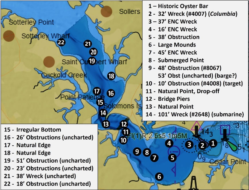
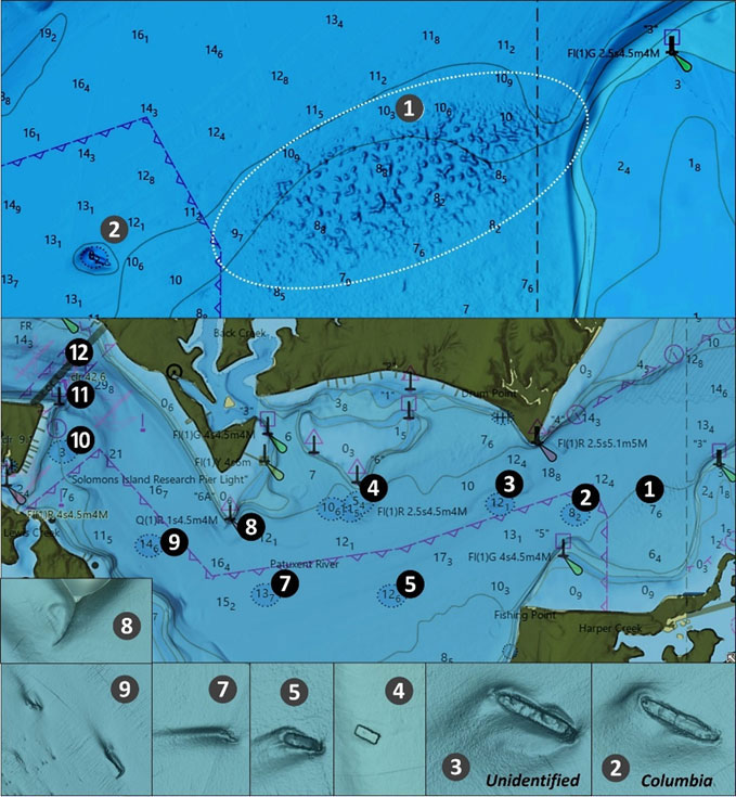
Scouting from east to west, there’s a broad area of very rugged bottom marked as Site 1 on Charts 1 and 2. This feature is the remnant of “Carroll Muds,” historic oyster reef centered at coordinates 38°18.871 x 76°24.475. Look for very rugged bottom about 800 yards long and 150 yards wide. It’s charted as a bulge in bathymetric contour lines, but this representation doesn’t convey the extreme ruggedness that’s present.
Just to the southwest is the 32’ least-depth wreck of barge Columbia (Site 2) at coordinates 38°18.765 x 76°24.998. It’s more often passed over than fished, yet there are sometimes stripers there so check the fishfinder when running by it. Its dimensions are 168’ by 23’. It sank southeast of Drum Point with its cargo of gravel following a collision with the tug Lillian Anne 24 during December of 1942. The vessel is oriented northwest-southeast and lies in a scour hole (Chart 2 insert). Note that the scour is on the west or upriver side of the wreck. This indicates that at this site strong flood currents along the bottom predominate. About 800 yards west northwest lies an unidentified 37’ least-depth wreck (Site 3) at coordinates 38°18.818 x 76°25.511. Very little detail is recorded about this wreck, but it measures about 180’ long and lies in a scour hole which is on the upriver side.

Site 4 marks a 16’ least-depth rectangular wreck at coordinates 38°18.827 x 76°26.427 (insert on Chart 2). This wreck measures about 50’ by about 12’ wide and has the appearance of a small barge. Site 5 west northwest of Fishing Point marks a 38’ least-depth charted obstruction that looks like a wreck in a scour hole that trails off upriver(insert on Chart 2). This object also measures about 50’ long and 12’ wide. A 45’ least-depth wreck is marked as Site 7 at coordinates 38°18.351 x 76°27.044. This feature is narrow and lies in a deep scour that trails off upriver. Although it’s difficult to distinguish what it might be, the feature appears to be about 50’ long. Site 8 is the natural southern submerged section of Sandy Point, which forms a little hook that curls upriver. Immediately to the northeast, a subsurface shelf juts out to the southeast forming a nice bowl which could potentially concentrate baitfish moving with the current.
Site 9 marks a charted obstruction and an uncharted wreck. It was found during a 1985 hydrographic survey, and although unidentified, its configuration suggests a wreck that’s about 60’ long and oriented west northwest-east southeast. There’s a scour on the upriver side. The uncharted corner of a rectangular partially buried object protrudes towards the southeast in about 60’ of water. There’s a narrow scour along the northeastern side. This feature is at least 125’ long and 25’ wide.
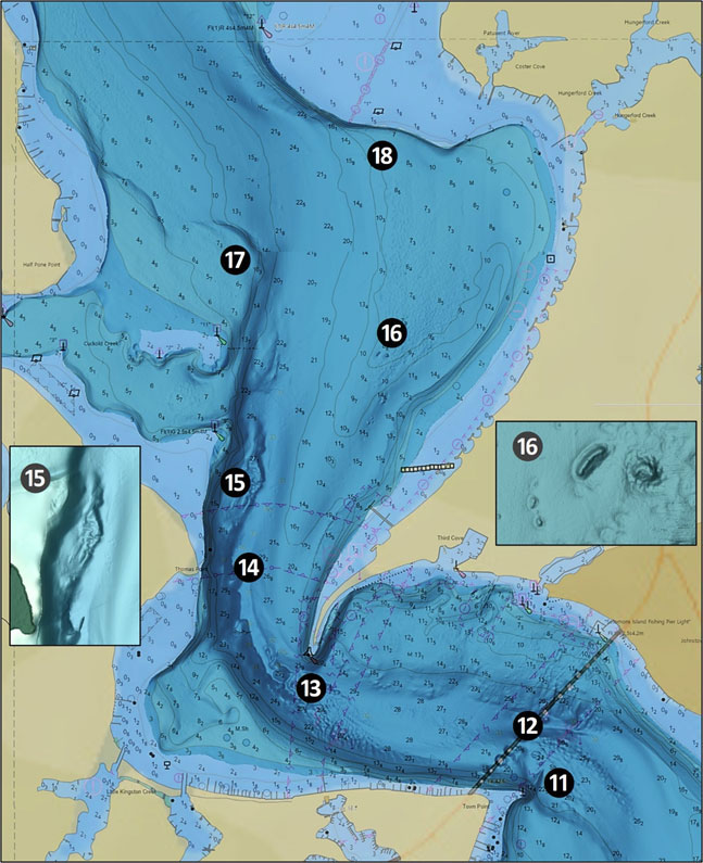
South of the southwestern end of the Thomas Johnson Memorial Bridge at Site 10 are the ruins of a steel and concrete square-shaped target with a least depth of nine feet. It’s a single object about 25’ by 25’. Coordinates are 38°19.072 x 76°28.383. Just to the north, Site 11 marks the subsurface eastern end of Town Point where there’s a very steep drop-off. Site 12 is a general marker for the highway bridge piers. Try jigging for stripers here, they’re in attendance on a regular basis. Site 13 north of the bridge marks the submerged southeastern end of Point Patience where there is another steep drop-off.

Look for the very deep wreck of submarine S-49 200 yards west of Thomas Point at coordinates 38°19.880 x 76°29.262. There are several versions of her demise. AWOIS reports the Navy partially dismantled and sank the sub. Dr. Kent Mountford, writing for the Bay Journal in 2010, described S-49 as about 220’ long and 22’ wide. He reports that it foundered and sank while under tow. Later, the Navy used the wreck for diver training. The divers are said to have encountered strong currents around the wreckage. They found it festooned with monofilament nets and colonized by a large number of oysters set on the steel hull. With a least-depth of about 100 feet, it’s on face value too deep for good fishing due to low oxygen conditions. Yet, the presence of oysters and location in relation to strong bottom currents suggest perhaps that localized conditions may be better than would otherwise be assumed.
Outside and immediately south of the entrance to Cuckhold Creek at Site 15 displays what I’ll characterize as a drowned ridge oriented north-south that was on the east side of the ancient Patuxent riverbed. It’s very deep, about 80’ or so. Site 16 marks two unidentified, uncharted obstructions at coordinates 38°20.420 x 76°28.823, which are shown by the insert on Chart 3. Least depth is about 26’. One object is a narrow mound about 70’ long. The other is somewhat circular with about a 50’ diameter. Both are on the southwest corner of a broad area of irregular low-relief bottom which is the remnant of Natural Oyster Bar 22-10. Try drifting across for spot and perch; the obstructions might attract a few stripers as well.
Site 17 west of Half Pone Point marks a natural edge around a submerged shelf which is the drowned subsurface extension of the point when water levels were much lower. Site 18 marks a long edge with steep drop-off south of Hellen Creek. This edge was the eastern side of the ancient riverbed valley. Try trolling both edges for stripers.

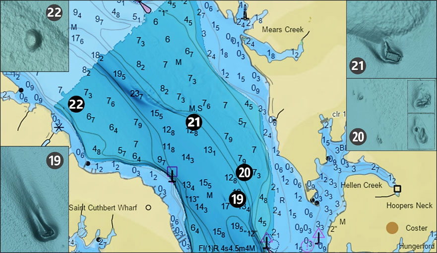
Another uncharted obstruction shown by the insert on Chart 4 has a least-depth of 51’ and is located at Site 19 in coordinates 38°21.606 x 76°29.610. The object is about 35’ long and oriented northeast/southwest. It sits in a long, narrow scour. Site 20 brings us to two more uncharted obstructions shown by a Chart 4 insert at coordinates 38°21.738 x 76°29.424, and 38°21.846 x 76°29.490, with a least-depth of about 23’. Both appear to be natural formations about 50’ by 50’.
Look for another uncharted wreck at Site 21 at coordinates 38°22.196 x 76°29.905, with a least-depth of about 38’. The rectangular object suggests a small barge or large float. There appears to be another object projecting north from the northwest corner of the wreck. This feature lies in a scour that extends back towards the edge of the drop-off and somewhat upriver. It’s well positioned to disrupt current and cause subsurface turbulence and certainly worth a check when in the area. Also try trolling the long edge from here upriver.
Our last stop on this armchair scouting voyage is an unidentified, uncharted circular mound about 60’ in diameter at Site 22, coordinates 38°22.264 x 76°31.094. Least-depth is about 18’. This is another feature worth a quick check when in the area.
-By Wayne Young. As well as being a regular contributor to FishTalk, Wayne Young is the author of multiple books detailing wrecks and fishing reefs in the Chesapeake Bay, Delaware Bay, and beyond. All are available at Amazon.com, and you can find his Facebook page at Chesapeake Bay Fishing Reefs.