Large natural formations along with wrecks and obstructions along the lower east side of the Bay provide good structure for everything from croaker to cobia. In fact, this portion of the Bay is so riddled with fish that the “Coral Lump” (Site 1) and “Texeco Wreck” (Site 2) shown on Chart 1, “Ridged Bottom” between Site 1 and Cherrystone Reef, and the “Airplane Wreck” (the 35-foot obstruction at the north edge of Chart 1), were reference points for a seasonal tautog movement study by Jon Lucy and Michael Arendt for the Virginia Institute of Marine Science in 2000.
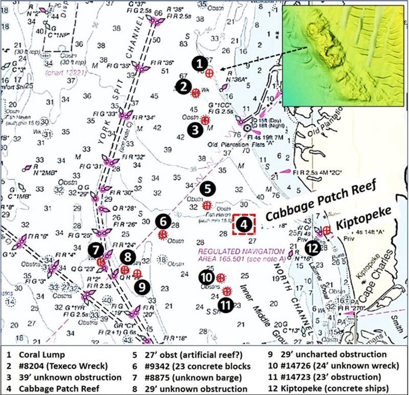
A “BAG” Color Shaded Relief screenshot from the National Oceanographic Administrations (NOAA) Bathymetric Data Viewer (BDV) showing the Coral Lump is overlaid on Chart 1. This natural feature juts out to the west along the edge of a deep drop-off. And it’s huge, at about 500 yards long and 100 yards wide. Hang a hard right coming out the end of Mattawoman Creek Light and run about a mile and a half northwest along the edge of deep water and you’re at one of the most prominent natural reefs in the Bay.
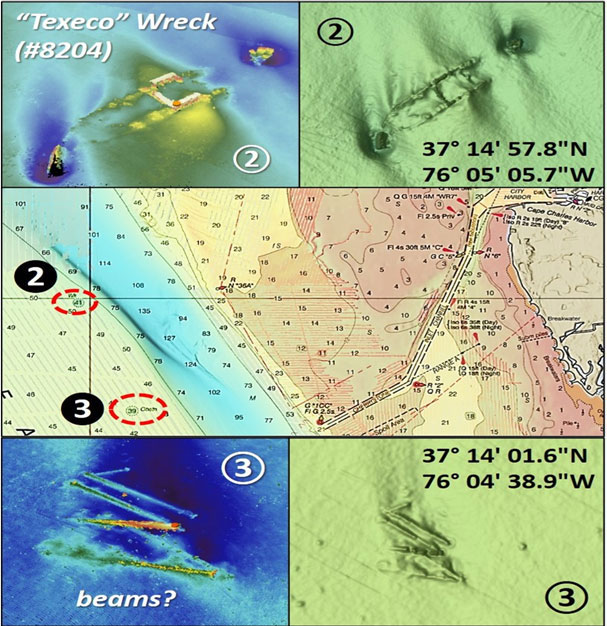
Run about a half mile southwest across the old bed of the Susquehanna River and you’re at the Texeco Wreck (Chart 2). The derivation of the wreck’s local name is unknown. A detailed entry about this feature is recorded in the Coast Survey’s Automated Wreck and Obstruction Information System. The wreckage is somewhat broken up, extending about 335’ in length and about 75’ in width. When first recorded in 1968, the wreckage rose 15’ off the bottom. Both the BDV screenshot and a color multibeam sonar image show sedimentation and scouring variously across the site. So, the actual rise today will vary from the original report. This is a good one for flounder, which can be hiding in the sediment both inside and outside the wreck.
Also shown on Chart 2 is a 39’ unknown obstruction (Site 3). A BDV screenshot and color multibeam sonar image screenshot show objects that have the appearance of long, narrow beams. Perhaps this is deck cargo that was lost overboard, or it could be deliberately placed reef materials. The site is small, about 75’ by 75’. Site 4, the Cabbage Patch Reef, is a Virginia Marine Resources Commission (VMRC) artificial reef presented in “Chesapeake Bay Fishing Reefs: Voyages of Rediscovery” (Young, 2020) and detailed in “Unlisted Fishing Reef and the Cabbage Patch.”
Site 5 northwest of the Cabbage Patch is an unidentified 27’ obstruction that is widely distributed, shown as Site 5 on Chart 1 and Image 1. The feature is oriented north-northwest/south-southeast and is about 200’ in overall length and 40’ in width. There are on the order of 20 individual small objects, each in a small scour hole. Perhaps the objects are lost cargo, but the distribution of the objects in a loose pattern and the presence of unofficial artificial reefs along the lower East Side raise the potential that this could be a “bandit” reef, one place without the benefit of required permits. It’s worth a drift through to see if any flounder may be lying there ready to ambush unsuspecting prey.
Site 6 is without any doubt a constructed artificial reef, consisting of 23 concrete blocks that are heavily encrusted with marine vegetation. This one is definitely worth checking out when fishing in this region. Site 7 is located just outside the western edge of the York Spit Channel dogleg in proximity to Buoy G 23. It is the wreck of an unknown sunken wooden barge that is 70’ long, first reported by a Navy demolition team in 1971. What they were doing there is not stated. Were they using the feature for training? The BAG screenshot shows the wreckage oriented north-south lying at the southeast end of a deep scour hole which extends from the wreck towards the northwest, suggesting the site is affected by strong flood currents and storm-driven wave energy from the southeast. This feature is charted and easy to find, and has enough structure to attract plenty of fish.
Site 8 is a small, unknown 29’ obstruction. The screenshot shows a small object in a scour hole. Site 9 is a small uncharted obstruction in position 37’08.446 x 76’07.546. The screenshot shows an object and a faint outline in a scour hole that resembles the gunnel outline of a vessel. Thus, this may be an uncharted wreck. Site 10 and Site 11 are both small, unknown obstructions. The latter is the largest, about 80’ by 15’. Both sit in scours. Off to the northeast of these obstructions and east of the Cabbage Patch Reef along the Eastern Shore are the Kiptopeke concrete ship breakwaters (Site 12). There are also shoreline structures and an old dolphin from when the site was the northern terminus of the Chesapeake Bay Ferry (my first, very early exposure to the Bay). Sometimes, one needs to go no further than the breakwaters to find fish. This structure has been there a long time and is deteriorated and heavily biofouled, providing pathways for predator and prey movement through the reefs. Plus, the breakwaters can sometimes be safely fished during conditions that would threaten those who venture from behind their protective shield; the large pocket of protection makes it particularly popular with kayak and small boat anglers.
See Southern ESVA Part II, covering areas near the east side of the CBBT, Fisherman’s Island, and surrounding waters.
See Fishing the ESVA, Part III: The Ocean Side.
As well as being a regular contributor to FishTalk, Wayne Young is the author of multiple books detailing wrecks and fishing reefs in the Chesapeake Bay, Delaware Bay, and beyond. All are available at Amazon.com, and you can find his Facebook page at “Chesapeake Bay Fishing Reefs.”