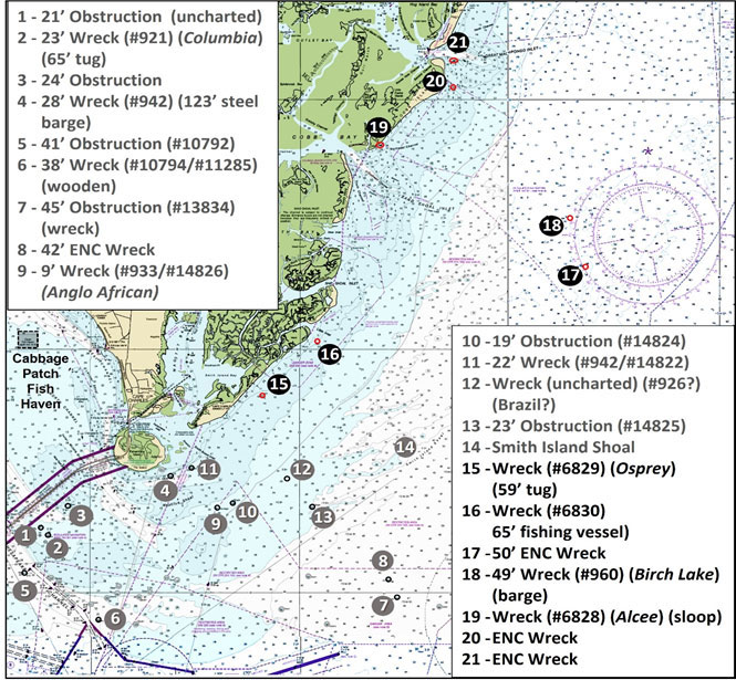
Previously in part I of this series on the ESVA we looked inside the Bay, and in part II we looked at the wrecks and obstructions off the ocean side of Fishermans Island (sites 1-14 on Chart 1). Continuing northeast up the coast brings us to the remote barrier islands which are part of a natural wildlife preserve. It’s open to the public for wildlife viewing and fishing; access is by boat only. The following features are along this remote and constantly changing barrier island shoreline, which has rather treacherous inlets and extensive shoals. The barrier islands are generally migrating westward with erosion and the shoals are constantly shifting. This is an area where fishing should only be attempted in capable boats with experienced operators.

After passing the abandoned Cape Charles Lighthouse, you may encounter the wreck of the 59-foot tug Osprey (Site 15). It sank off Smith Island in 1966 and was reported as breaking up. A hydrographic survey didn’t find it in 1981, but it was retained as a charted feature. There’s probably little to nothing left by now given that its location is a very high energy zone, but if debris appears on the side-scan sonar when passing through this area, it could be remnants of the tug and may be worth checking out.
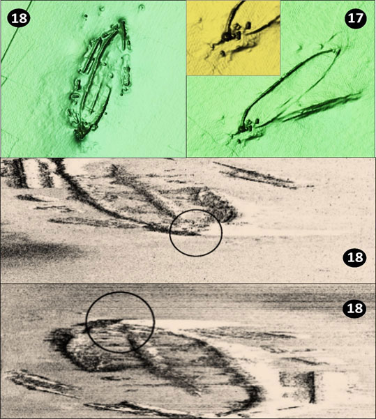
South of Little Inlet at Site 16 is the charted location of an unidentified 65-foot fishing vessel that wrecked in 1973. Although still visible in 1981, the barrier islands have been struck by a number of major episodic storms. Sand dunes were flattened, and the shoreline reshaped. With all the physical energy that’s pounded the area, it’s doubtful that much remains of this nearshore wreck. At Site 17 there’s more of a sure thing, a low-profile 50’ least depth wreck at coordinates 37°13.333 x 75°36.549. This is known as the “Bell” after a diver pulled up an unmarked bronze bell. A small section of the stern was above the bottom in 2013, which correlates with the objects at the southwest end of the wreck shown by the Bathymetric Attributed Grid (BAG) Color Shaded Relief screenshot from the NOAA Bathymetric Data Viewer (BDV) included as part of Image 1. The port bulwark was also exposed. Anecdotally, this was a wooden sailing vessel. It measures about 200’ in length on the BDV distance scale.
Moving offshore, look for the 49’ least depth wreck of the barge Birch Lake at Site 18, coordinates 37'15.257 x 75'37.226 about seven miles off Sand Shoal Inlet. This vessel went down in 1943. As shown by Image 1, the wreck is distributed on the bottom. It has the appearance of a wooden schooner barge and is a tautog magnet according to fishing reports. It’s configuration with open flat areas inside the hull form ought to hold flounder as well. The side-scan sonar images are from the National Ocean Survey (2013).

Site 19 is charted at the south end of Cobb Island. It’s where the sloop Alcee grounded in two to three feet of water in 1970. The wreck was still visible in 1981 but has since submerged below the surface. Site 20 charted off Cobb Island marks the location of an unidentified wreck with an uncertain physical condition. As with other nearshore wrecks, localized changes and weathering of features should be expected. Another unidentified wreck is at Site 21.
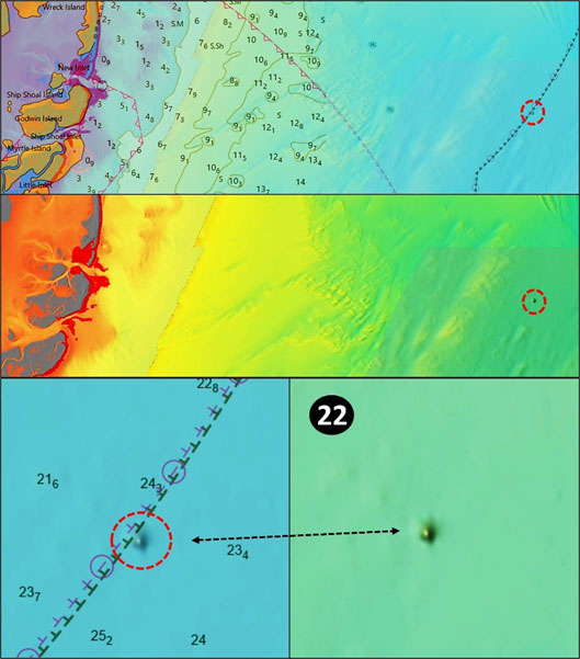
Moving offshore about 18 miles to Site 22 on Chart 2, is a large uncharted anomaly. The feature is under charted detail on the BDV ENC see-through chart when zoomed out which obscures its presence, but it prominently stands out when zoomed in or when the chart layer is switched off. This feature doesn’t correlate with available wreck coordinates, AWOIS Viewer data, or other information resources including multiple coordinate references consulted. Whether or not it’s an artifact of sounding modeling or actually structure of some form is uncertain, but its prominent display in the “DEM” color shaded relief layer merits a note for fishers who prospect near the location. A good guess is that this is a substantial wreck. If you know what it is or can get a good scan, give FishTalk a shout and let us know. Note that there are hang reports for a sunken barge about two miles to the west and a sunken subchaser about three miles to the north, but neither is charted.

A definite offshore uncharted wreck is the fishing vessel Doxie Girl with a least depth of about 55’. This is a clam boat that went down with all hands in 1975. Divers report a small wreck with the deck house gone but with the hull still there, possibly in two pieces. Divers also report lots of interior space for tautog, sea bass, and flounder as well. Where it’s located is an issue because multiple coordinates are posted by generally reliable sources. A reported location which shows as a faint dimple in “DEM” Color Shaded Relief is at coordinates 37°08.341 x 75°35.099. Another set of coordinates puts it nearby at 37°08.128 x 75°34.490.
Although there’s not a huge amount of structure in the coastal waters between Smith Island Inlet and Great Machipongo Inlet, there are nevertheless some interesting features that attract and hold tautog, sea bass, and flounder. This area is about as remote as it gets in our region, and remember that those shoals shift and change. Caution is warranted, and going out with a partner boat would be a good idea.
- By Wayne Young
As well as being a regular contributor to FishTalk, Wayne Young is the author of multiple books detailing wrecks and fishing reefs in the Chesapeake Bay, Delaware Bay, and beyond. All are available at Amazon.com, and you can find his Facebook page at “Chesapeake Bay Fishing Reefs.”