If you missed it, see Fishing the Southern Eastern Shore of Virginia, Part I.

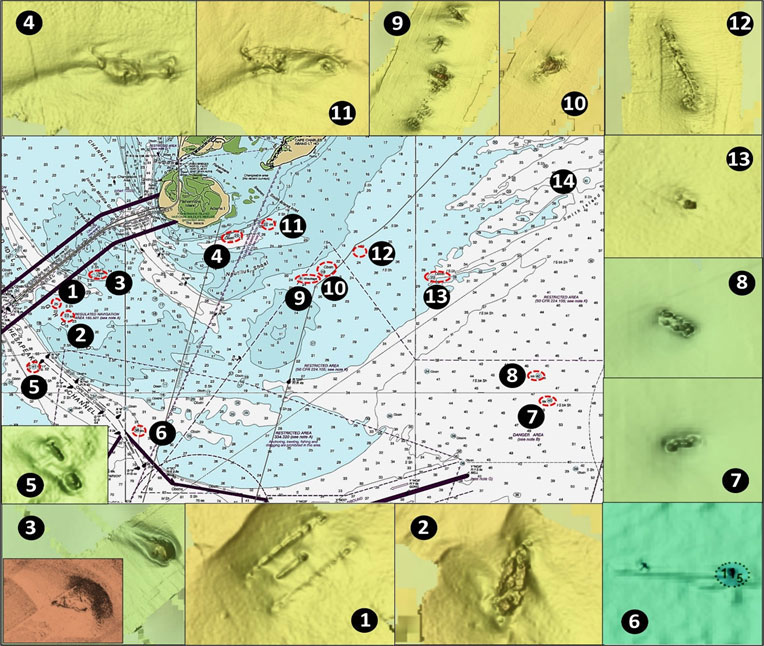
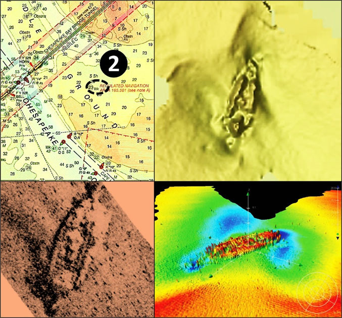
The waters off Cape Charles have collected their share of wrecks and obstructions, most of which offer interesting fishing structure. Immediately east of the Chesapeake Bay Bridge-Tunnel (CBBT) at Site 1 on Chart 1 is a 21’ least depth uncharted, low-profile obstruction at coordinates 37'02.622 x 76'02.596. This rectangular feature measures about 75’ by 35’ suggesting a small barge or float. It sits in a scour hole with only low walls showing (see Chart 1 insert). Nearby to the southeast is the more substantial 23’ least-depth wreck of the 65’ tug Columbia at Site 2, coordinates 37’02.303 x 76’02.019 (see Chart 2). Currents across these features are very strong.

Site 3 marks a 24’ least depth obstruction at coordinates 37’03.595 x 76’02.266, found during a 2009 hydrographic survey. A side-scan sonar image (Chart 1 insert) shows a triangular feature surrounded by a mound suggesting a fabricated object of some type. It rises as much as 16’ above the surrounding bottom, is about 100’ long, and about 50’ wide, thus making it a very solid target.
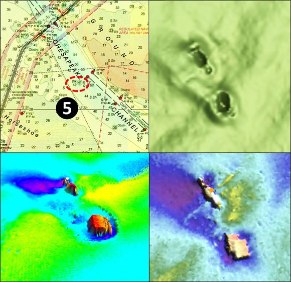
Site 4 at coordinates 37’04.716 x 76’56.169 is mostly buried and doesn’t have a vessel profile. It’s discussed later in conjunction with Site 11. At Site 5, the Coast Survey records a 100’ derelict vessel at coordinates 37’00.793 x 76’03.158. The entry reads “Wreckage consisted of two large metal boxes, wooden remains of a ship, and a metal pole protruding out of a sand bottom…” Look for a 38’ least-depth wreck at Site 6 at coordinates 36’58.872 x 75’59.611. A 2000 hydrographic survey described it as “A 30- to 35-meter wooden wreck. Frame and two rails covered with soft corals stand one to two feet above the sandy bottom.” The insert on Chart 1 suggests that much of the wreck is covered with sediment.

Site 7 marks a 45’ least depth wreck that was discovered during a 2003 hydrographic survey at coordinates 37’59.769 x 75’45.360. It’s broken up and in a scour hole. Site 8 marks a 42’ unidentified wreck at coordinates 37’00.506 x 75’45.774. It’s also broken up and in a scour hole. The 370’ Anglo African, a well- known wreck which grounded in 1909, lies at Site 9 off the southeastern edge of Nautilus Shoal. When salvage efforts were unsuccessful, the ship was demolished by explosives as a danger to navigation. Broken up wreckage is distributed across about 400’ in four large clusters with a least depth of nine feet at coordinates 37’03.428 x 75’53.959. Just to the northeast, look for a 19’ least depth obstruction at Site 10, coordinates 37’03.620 x 75’53.196. This substantial pile of objects could be lost cargo or perhaps a wreck.
Southeast off Fishermans Island, Site 11 marks a 22’ least depth wreck. Surveyors thought this previously uncharted feature was a 123’ steel barge that sank in 1969 to the west. Nothing was found in the reported position, so the NOAA Hydrographer disagreed. The wreck at Site 11 (coordinates 3’05.053 x 75’55.154) measures about 110’ long. With two pointy ends, it could have been a schooner or schooner barge. The previously mentioned feature at Site 4, uncharted and found in 2009, measures about 150’; both features are shown by inserts on Chart 1 and one of these features may be the missing barge. Site 4 seems the better candidate to me based on length and mass. Regardless, each offers fishable structure.
Look for an obstruction at Site 12, one of several uncharted features that’s possibly the wreck of the Brazil, a cargo ship that sank in this general vicinity. This one is broken up and distributed along about 150’ in a scour hole centered at coordinates 37’03.907 x 75’51.956. Site 13 at the southwest end of Nautilus Shoal marks a 23’ least-depth obstruction at coordinates 37’03.451 x 75’49.409. The feature consists of several small objects. Smith Island Shoal (Site 14) is a few miles to the east of the preceding wreck. There are some areas of rough bottom to drift across for flounder.
Those who fish in the Bay entrance and seaward approaches must be careful, and not just because of large ocean swells. Chesapeake Channel picks up naval traffic headed to and from the York River, Baltimore bound ships, and additional commercial traffic. Sites 5 and 6 are adjacent to the seaward entrance to this channel. Most of these ships are very large and recreational boats can quickly disappear from view under the bow or behind superstructure and cargo handling structure on deck. There are also bow and stern wakes to ride out. So, when fishing near shipping channels give the big guys plenty of room.
See Fishing the ESVA, Part III: The Ocean Side.
As well as being a regular contributor to FishTalk, Wayne Young is the author of multiple books detailing wrecks and fishing reefs in the Chesapeake Bay, Delaware Bay, and beyond. All are available at Amazon.com, and you can find his Facebook page at “Chesapeake Bay Fishing Reefs.”