Nautical charts from the late 1990s show a large circular fish haven about 12 miles east of Rudee Inlet… yet there’s none charted there today. Why wasn’t this reef folded into the Virginia Marine Resources Commission’s (VMRC) artificial reef program? An early history of Virginia artificial reefs prepared in 1983 by Jon Lucy provides a historical perspective. It reports that a fishing reef wasn’t acceptable in the general area to a number of parties when other reefs were permitted during the 1970s, notwithstanding that there was a fish haven already there. Plus, the fish haven appears to have had only a single, relatively minor reef placement and the Tower reef to the north northeast already had substantial wartime wreckage in close proximity. The Lucy paper reports that the artificial reef site was established in 1959 by the Tidewater Artificial Reef Development Association (TARDA). This group was active from 1959 to 1964. The reef was known simply as The Fish Haven. If not the first artificial reef, it is one of the first established by Virginia sponsors. TARDA arranged for the placement of 150 car bodies.
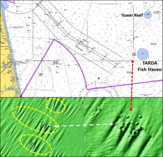
If the fish haven isn’t recognized anymore, what happened to the car bodies? I superimposed the 1996 nautical chart onto a screenshot of a raster nautical chart taken from the National Oceanic and Atmospheric Administration’s (NOAA) Bathymetric Data Viewer (BDV). Using this visual reference, the area under the fish haven circle revealed no anomalies. However, just to the west of the circle, there are a number of low-profile small objects that are spaced closely together (Figure 1 above). Considering navigation accuracy in 1959, these anomalies could easily be the remains of the car bodies. Without diver inspection we’ll have to leave this assessment as a maybe, but in any case, anomalies attract fish.
The closest VMRC fish haven to Rudee Inlet is the Tower Reef (36’54.06 x 75’43.5). Although a good run offshore, it and the adjacent Chesapeake Light Tower are powerhouse fishing destinations. West of Tower Reef lies the wreckage of the 449-foot bulk cargo carrier Santore, a U-Boat legacy wreck. A number of vessels including the Santore and Kingston Ceylonite, discussed later, struck mines deployed by a U-Boat. A minesweeper had worked to clear the minefield and channel but missed the one. The Santore found it, capsized, and quickly sank. After another ship ran into the wreck, the Coast Guard blew her up with explosives to clear the hazard to navigation, leaving wreckage remains strewn across the bottom.
Five and a half miles out on a bearing of 152 degrees True from the inlet are the remains of the 160-foot trawler Kingston Ceylonite, another U-Boat legacy wreck. The trawler was one of two dozen sent to the U.S. by the United Kingdom in exchange for lend-lease destroyers. She struck a mine that had been deployed by a U-Boat. The first explosion was the mine, followed quickly be a second explosion, thought to be the trawler’s magazine.
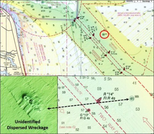
A wreck of no name and little remains sits in a shallow scour hole on the east side of the inbound traffic lane (Figure 2 above). The Coast Survey’s Automated Wreck and Obstruction Information System (AWOIS) reports that a diver inspection found the unidentified vessel demolished. There appears to be enough there to draw reef fish, but it is in the shipping lane, so be careful.
Further ofshore east of the RW “CB” buoy at the entrance to the traffic lanes lie the remains of two more wrecks. The closest, the 105-foot clam boat Salty Sea II, is broken up. She was in two pieces when logged into AWOIS during 1972. But, the “BAG” image shows little remains. A more substantial wreck, that of the 77-foot fishing vessel Gulf Hustler which sank in 1974, lies to the northeast.
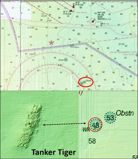
One of the most well-known U-Boat legacy wrecks is that of the American tanker Tiger. It was 1942, early during the Battle of the Atlantic when U-Boats were at the peak of their threat. When Tiger turned on her navigation lights to guide in the pilot boat, a U-Boat which had sunk a tug and two barges on Paramore Banks a few hours before surfaced several hundred feet away and drilled her with a single torpedo. The ship began to settle but didn’t immediately sink. Later, while under tow by a Coast Guard cutter, she grounded and sank at her present location. Because the vessel was too damaged for salvage, it was demolished by explosives so that she wouldn’t be a hazard to navigation. The Tiger wreck provides great reef habitat and structure for reef fishing; her configuration on the bottom is shown by the “BAG” shaded color relief image.
Another charted wreck that certainly deserves an angler’s attention is actually two adjacent hulks appearing to be about 200 feet long and 40 feet wide. There is a wreck symbol to the west that correlates with coordinates from some sources as the position of a drydock, but partial BDV coverage suggests that nothing is there. The identity of these wrecks is not recorded in AWOIS. The BDV image shows that both wrecks are consistent with drydocks. They are under the same wreck symbol. Coordinates from other Internet sources put two drydocks at this approximate location, but not adjacent to each other. The anecdotal back story is that a tug towing both drydocks was caught in a storm. The tug and tows were in danger of foundering, so the tug cut the drydocks free and they sank. Divers on a charter aboard the Grand Adventure out of Virginia Beach found the interior of both drydocks filled with sand following Hurricane Dorian in 2019. Although the attractiveness for diving has diminished, sufficient structure remains uncovered to attract tautog, sheepshead, and sea bass (personal communication with Captain Matt Morrison). The sand waves in the vicinity look like promising flounder grounds and with the interiors filled with sand, look for them inside the wrecks as well.
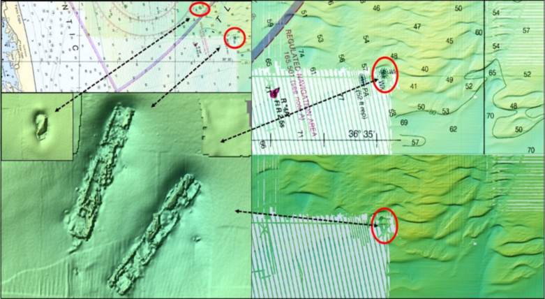
The difference between published coordinates for the drydocks and where the BDV image shows them demonstrates the value in scouting fishing reef structure, and points to the need to use coordinate data in conjunction with other collaborating information — and the dramatic change in the drydocks’ condition following Hurricane Dorian demonstrates the value of recreational diver reports for recreational sportfishing.
GPS Coordinates for Rudee Wrecks
Pull up the interactive AWOIS Map on NOAA’s website, and you can ID these wrecks and many more; click on the wreck icon to pull up GPS coordinates and details. Note, however, that different datum can be set up differently, GPS numbers don’t always match up ideally from unit to unit, and coordinates obtained using the BDV have as much as a 200-foot error factor. So, some searching with side-scan sonars and fishfinders is often needed to get onto a reef. However, where the reef is under a wreck or obstruction circle, using an electronic chart with GPS and steering to the circle is a quick way to get on top of the structure. Whenever you get coordinates from an outside source, recognize that they should be considered a starting point. One should always plan to set up a circular search pattern from the initial coordinates until you locate the structure on your fishfinder, then create a waypoint in your own GPS for future reference.
See our Chesapeake Bay Fishing Reefs Guide to get the lowdown on other mad-made wreck and reef hotspots in the Bay, plus a few in the ocean off the DelMarVa coast.
-By Wayne Young, the author of “Bridges Under Troubled Waters: Upper Chesapeake and Tidal Potomac Fishing Reefs,” “Chesapeake Bay Fishing Reefs, Voyage of Discovery,” “Phantoms of the Lower Bay,” and “Hook, Line, and Slinker.” All are available at Amazon.com, and you can find his Facebook page at Chesapeake Bay Fishing Reefs.
Sign up here to get the weekly FishTalk Chesapeake Bay and Mid-Atlantic fishing reports in your email inbox, every Friday by noon.