Presented by Sirius XM Marine

In reservoirs largemouth bass are attracted to trees and points, in the Bay striped bass are attracted to drop-offs and oyster bars, and in inshore waters sea bass are attracted to wrecks and reefs. Like finding the perfect spot to start a retail business, when you’re looking for fish it often boils down to location, location, location. Even in offshore waters this is true, and even when the structure you’re looking for isn’t visible. More often than not, it isn’t. In fact, in most cases you can only spot one of the three main forms of structure you’ll likely encounter in bluewater: flotsam (including floating items tied down to the bottom, like commercial fishing gear floats). Two others, temperature breaks and the underwater features visible only on electronics, are hidden from view.
Flotsam Offshore
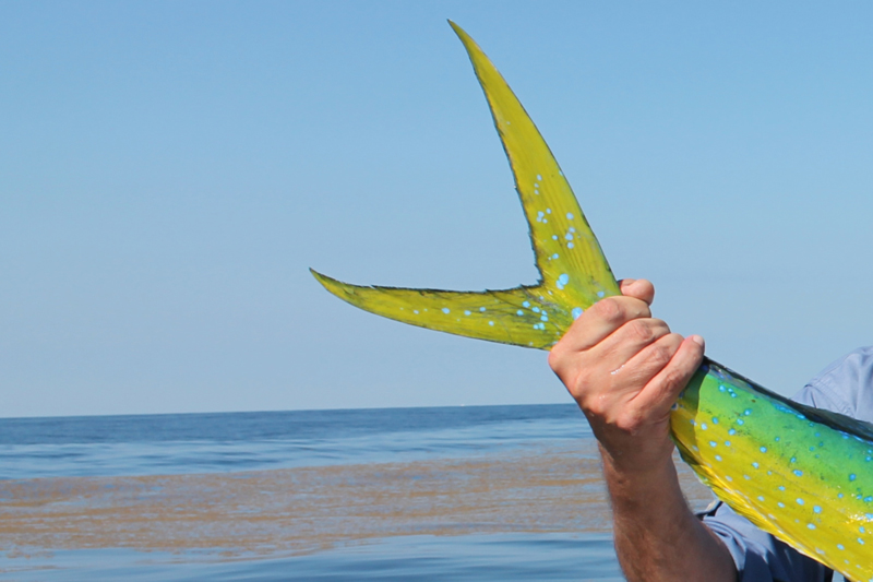
Finding flotsam offshore can be like finding a winning lottery ticket. Any experienced angler has had one of “those” days when hour upon hour of fruitless trolling made it seem like a bust trip, before suddenly, a floating paddy of weeds, a board, or some other item gets spotted bobbing around on the surface. You pull your baits past it, and the cockpit explodes into chaos as multiple lines start singing.
Most commonly mahi-mahi will be the dominant species in attendance but flotsam attracts enough life that working around it can expose larger predators holding nearby. For this reason, when you spot something floating offshore it’s usually best to troll around it with a relatively wide berth two or three times before pulling in close and bailing. There’s no doubt that bailing is the best way to load up on mahi (see Advanced Tactics for Mahi-Mahi Bailing for a full run-down on how to apply the tactic), but it rarely results in hooking up with tunas, billfish, or other species, so it’s wise to first pull those larger offerings through the area.
As for locating flotsam, in most cases it is truly a matter of getting lucky. Still, you can stack the deck in your favor a bit. First off, remember that those floating commercial fishing gear buoys count, they do attract plenty of fish, and unlike other flotsam they aren’t in constant motion. You can spot ‘em from a couple of miles off with a good pair of marine binoculars, and from several miles off with a gyro-stabilized pair. Some have radar reflectors, and these can be “sighted” from miles away via radar. The downside to fishing the buoys is that everyone knows where they are, and by lunchtime they’re often picked-over, especially on weekends.
Scanning the horizon with binoculars can help, too, but what works even better is elevation. If you have a tower or upper station be sure to post a crewmember with sharp eyes up top. Best yet is to be able to find major weed lines simply by glancing at your MFD. This is a new trick in the world of marine electronics, and it comes to us via Sirius XM Fish Mapping. With this system onboard you can display major weed lines visible to satellites, orbiting high above the oceans, right on your chartplotter. (Note: SiriusXM plays nice with Furuno, Garmin, Simrad, Lowrance, and Raymarine; depending on your system you may need a software update and will need the latest receiver/antenna).
Offshore Temperature Breaks
Offshore water barriers where one body of water hits another or eddies swirl free of the Gulf Stream and spin towards the east create their own structure of sorts, which often concentrates fish. These breaks can be as abrupt as a brick wall, or may be spread out over a mile or more. And the temperature changes from one portion to another may be as subtle as a half a degree, or they could be several degrees. Though it’s certainly not always the case, as a general rule of thumb the more abrupt and the more extreme a change is, the more likely it is to hold fish.
In rare cases the break will be between two bodies of water so substantially different that you can actually see it. One side may look greener or bluer than the other, or the water may appear a bit cloudier or dirtier. In some other cases a visible rip or series of rips will form on the surface. The important thing to keep in mind here is that the cleaner or warmer side of a break is not necessarily the one that holds the fish. Quite often, particularly when it comes to yellowfin tuna, the dirty or cool side will be the one providing the bulk of the action. Of course, you never know until you pass through both sides. So when arriving at a break, it’s generally best to zigzag back and forth across the boundary as opposed to staying on one side or the other. After a rod or three goes down you’ll know which side to stick with, though quite regularly it’ll be going across the break itself or through the rips forming along it that triggers the bites.
Finding breaks is historically a matter of checking color-coded satellite sea surface temperature (SST) imagery the night before a trip. Savvy offshore anglers will check several days of images to identify the approximate speed and direction of travel of a break, so they can make a best guess as to where they’ll find it when they arrive at the offshore grounds. SiriusXM Fish Mapping again offers a new leg up on what we’re used to in the world of SST, eliminating a lot of the guesswork by piping satellite data right down through the atmosphere and onto your MFD screen. Then it can be displayed overlaid on your chartplotter for up-to-date intel. Added bonus: this service can also display temperature barriers down to 30 meters as opposed to only those appearing on the surface. This is particularly useful for finding subsurface breaks when surface temperatures are nearly all the same, often the case through the region in late summer.
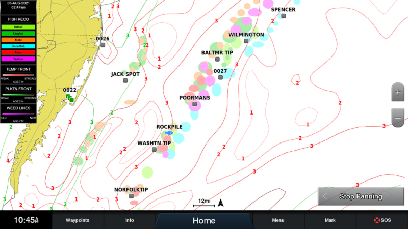
Often, though not always, there will be plankton concentrations located at or near temperature barriers. Like water temperature, these indicate areas where different bodies of water are meeting and locating them can mean locating fish as these nutrient-rich areas attract baitfish. Some SST services show plankton (also referred to as chlorophyll) and others do not (SiriusXM shows both concentration barriers and the strength of those barriers in different areas). While generally not considered quite as impactful as temperature barriers, locating these plankton fronts is another piece of the offshore puzzle and as one might guess, when you can locate an area where both temperature and plankton create a watery wall in the same zone you’ve located a likely hotspot.
Underwater Features
Underwater features are undoubtedly the form of structure utilized by the vast majority of the offshore anglers out there. The canyons are, of course, the best example. These notches in the edge of the Continental Shelf break the currents, causing upwellings, downwellings, and abrupt changes in water flow that attract the fish. Let’s also not forget that even down at 600, 800, or 1000 feet or more this physical structure attracts fish of the non-pelagic variety. If trolling turns out to be a bust, golden tilefish, rose fish, and at times swordfish may be located down deep on these drop-offs.
While the canyons are certainly some of the most productive offshore fishing grounds around, one mistake some anglers make is heading directly for them (usually the one a friend said they caught fish at the week before) regardless of the other variables in play. To use a rather blatant example, when a hard temp break with plankton barriers and weed lines intersects with the shelf’s edge 10 miles north of the Washington, you’ll want to head there instead of running to the canyon itself.
Of course, since the temperature breaks, plankton barriers, and flotsam are always moving, unlike the canyons their locations can change from day to day. You’ll only know where to go if you’ve gathered the appropriate intel and did a bit of slick predicting, or if you can get it while you’re out there. Most importantly, you first have to recognize that these forms of offshore structure do indeed exist — even though you may not be able to see them.
See Part I: Prepping for the Offshore Fishing Season, of our offshore fishing series designed to help everyone get ready for the next season - and make it one of the best ever, and then be sure to check out and Part III: Small Boat, Big Ocean.